Property Record
297 Vine St, Barre, VT 05641


NEARBY LISTINGS FOR SALE OR LEASE
-
-
View all Barre listings for sale on LoopNet.com
Property Detail
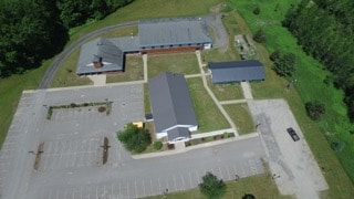
297 Vine St
060-018-11178
6.5 ACRES & CHURCH & SCHOOL
Religious
Washington
X
Vermont
50023C0431E
6.50 AC
0
Vermont North Area
2024
Other Market Areas
954500
Barre, VT
DEMOGRAPHICS near 297 Vine St
1 Mile
3 Mile
5 Mile
2024 Total Population
785
14,611
27,005
2029 Population
802
14,774
27,189
Pop Growth 2024-2029
+ 2.17%
+ 1.12%
+ 0.68%
Average Age
45
43
43
2024 Total Households
307
6,728
12,232
HH Growth 2024-2029
+ 2.28%
+ 1.11%
+ 0.69%
Median Household Inc
$80,932
$67,037
$69,368
Avg Household Size
2.20
2.10
2.10
2024 Avg HH Vehicles
2.00
1.00
2.00
Median Home Value
$252,631
$215,347
$244,322
Median Year Built
1985
1965
1965
Nearby Places
Map Layers
Map Styles
 Street
 Aerial
- Restaurants
- Banks
- Shops
- Fitness
- Groceries
PUBLIC TRANSPORTATION
COMMUTER RAIL
DRIVE
WALK
Distance
13 min
6.0 mi
AIRPORT
Patrick Leahy Burlington International
DRIVE
WALK
Distance
Patrick Leahy Burlington International
60 min
42.0 mi
SALE & LEASE HISTORY
LISTING DATE
SALE/LEASE

Aug 30, 2017
For Sale
Nearby Properties
Address
Land Use
TOTAL SIZE
Lot Size
Zoning
Address
Land Use
TOTAL SIZE
Lot Size
Zoning
Address
Land Use
TOTAL SIZE
Lot Size
Zoning
0.58 AC
AE
Address
Land Use
TOTAL SIZE
Lot Size
Zoning
Address
Land Use
TOTAL SIZE
Lot Size
Zoning
Address
Land Use
TOTAL SIZE
Lot Size
Zoning
55.21 AC
Address
Land Use
TOTAL SIZE
Lot Size
Zoning
242.35 AC
Address
Land Use
TOTAL SIZE
Lot Size
Zoning
Address
Land Use
TOTAL SIZE
Lot Size
Zoning
1.94 AC
Address
Land Use
TOTAL SIZE
Lot Size
Zoning
36.11 AC
Address
Land Use
TOTAL SIZE
Lot Size
Zoning
96.42 AC
Address
Land Use
TOTAL SIZE
Lot Size
Zoning
17.40 AC
Address
Land Use
TOTAL SIZE
Lot Size
Zoning
54,324 SF
2.76 AC
MU-1
Address
Land Use
TOTAL SIZE
Lot Size
Zoning
27,913 SF
10.45 AC
CIV
Address
Land Use
TOTAL SIZE
Lot Size
Zoning
Address
Land Use
TOTAL SIZE
Lot Size
Zoning
43,014 SF
1.01 AC
UC-1
Address
Land Use
TOTAL SIZE
Lot Size
Zoning
3.40 AC
UC-2
Address
Land Use
TOTAL SIZE
Lot Size
Zoning
130,680 SF
0.76 AC
UC-1
Address
Land Use
TOTAL SIZE
Lot Size
Zoning
103,980 SF
0.95 AC
AE
Address
Land Use
TOTAL SIZE
Lot Size
Zoning
38,091 SF
4.57 AC
Address
Land Use
TOTAL SIZE
Lot Size
Zoning
62,930 SF
0.62 AC
UC-2
Address
Land Use
TOTAL SIZE
Lot Size
Zoning
3.10 AC
Address
Land Use
TOTAL SIZE
Lot Size
Zoning
20.30 AC
Address
Land Use
TOTAL SIZE
Lot Size
Zoning
28,780 SF
4.08 AC
AE
Address
Land Use
TOTAL SIZE
Lot Size
Zoning
6.72 AC
Address
Land Use
TOTAL SIZE
Lot Size
Zoning
39,183 SF
1.50 AC
UC-2
Address
Land Use
TOTAL SIZE
Lot Size
Zoning
26,093 SF
6.90 AC
R-4
Address
Land Use
TOTAL SIZE
Lot Size
Zoning
10.85 AC
Address
Land Use
TOTAL SIZE
Lot Size
Zoning
28,596 SF
5.53 AC
Address
Land Use
TOTAL SIZE
Lot Size
Zoning
12.50 AC
Address
Land Use
TOTAL SIZE
Lot Size
Zoning
126,256 SF
31.48 AC
The World's #1 Commercial Real Estate Marketplace
Connect with us
© 2026 CoStar Group
The information above has been obtained from sources believed reliable. While we do not doubt its accuracy we have not verified it and make no guarantee, warranty or representation about it. It is your responsibility to independently confirm its accuracy and completeness. Any projections, opinions, assumptions, or estimates used are for example only and do not represent the current or future performance of the property. The value of this transaction to you depends on tax and other factors which should be evaluated by your tax, financial, and legal advisors. You and your advisors should conduct a careful, independent investigation of the property to determine to your satisfaction the suitability of the property for your needs.