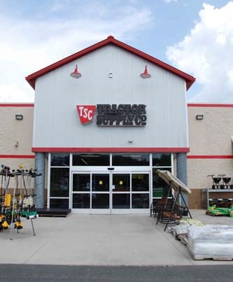
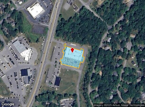
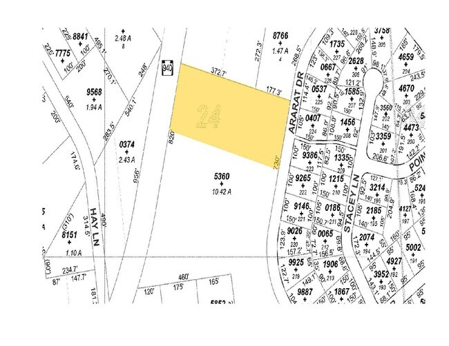
Property Record
2970 Route 940, Pocono Summit, PA 18346
NEARBY LISTINGS FOR SALE OR LEASE
Property Detail
2970 Route 940
03.5B.1.65-1
Coolbaugh Crossing Condominium
Storebuilding
UNIT 1
X
Monroe
42089C0232E
Pennsylvania
2025
1.33 AC
2025
Monroe County
300314
Philadelphia
24,360 SF
East Stroudsburg, PA
DEMOGRAPHICS near 2970 Route 940
1 Mile
3 Mile
5 Mile
2024 Total Population
2,380
10,287
24,024
2029 Population
2,302
10,156
23,931
Pop Growth 2024-2029
(3.28%)
(1.27%)
(0.39%)
Average Age
44
43
43
2024 Total Households
957
3,930
9,004
HH Growth 2024-2029
(3.13%)
(1.37%)
(0.58%)
Median Household Inc
$64,191
$73,983
$77,708
Avg Household Size
2.50
2.50
2.60
2024 Avg HH Vehicles
2.00
2.00
2.00
Median Home Value
$205,702
$207,251
$193,370
Median Year Built
1984
1984
1985
Nearby Places
- Restaurants
- Banks
- Shops
- Fitness
- Groceries
PUBLIC TRANSPORTATION
AIRPORT
Wilkes-Barre/Scranton International
DRIVE
WALK
Distance
Wilkes-Barre/Scranton International
40 min
37.1 mi
Freight Ports
Maher Terminal
DRIVE
WALK
Distance
Maher Terminal
1 min
70.3 mi
Nearby Properties
Address
Land Use
TOTAL SIZE
Lot Size
Zoning
Address
Land Use
TOTAL SIZE
Lot Size
Zoning
133,654 SF
150.95 AC
C
Address
Land Use
TOTAL SIZE
Lot Size
Zoning
1,368,841 SF
100 AC
I
Address
Land Use
TOTAL SIZE
Lot Size
Zoning
308,819 SF
485.31 AC
CI
Address
Land Use
TOTAL SIZE
Lot Size
Zoning
1,177,560 SF
77.25 AC
C-2
Address
Land Use
TOTAL SIZE
Lot Size
Zoning
106,192 SF
81.03 AC
WC
Address
Land Use
TOTAL SIZE
Lot Size
Zoning
1,050,000 SF
85.17 AC
I
Address
Land Use
TOTAL SIZE
Lot Size
Zoning
626,075 SF
80.59 AC
I
Address
Land Use
TOTAL SIZE
Lot Size
Zoning
88,444 SF
19.57 AC
C-2
Address
Land Use
TOTAL SIZE
Lot Size
Zoning
690,000 SF
62.50 AC
I
Address
Land Use
TOTAL SIZE
Lot Size
Zoning
55,632 SF
7.01 AC
C-2
Address
Land Use
TOTAL SIZE
Lot Size
Zoning
153,217 SF
18.14 AC
C-2
Address
Land Use
TOTAL SIZE
Lot Size
Zoning
76,300 SF
81 AC
CI
Address
Land Use
TOTAL SIZE
Lot Size
Zoning
208,764 SF
13.15 AC
I
Address
Land Use
TOTAL SIZE
Lot Size
Zoning
36,711 SF
6.28 AC
CI
Address
Land Use
TOTAL SIZE
Lot Size
Zoning
86,290 SF
6.15 AC
C-2
Address
Land Use
TOTAL SIZE
Lot Size
Zoning
10,000 SF
254.37 AC
I-A
Address
Land Use
TOTAL SIZE
Lot Size
Zoning
15,484 SF
14.21 AC
C-3
Address
Land Use
TOTAL SIZE
Lot Size
Zoning
32,594 SF
1.43 AC
M
Address
Land Use
TOTAL SIZE
Lot Size
Zoning
197,496 SF
9.77 AC
I
Address
Land Use
TOTAL SIZE
Lot Size
Zoning
1,432 SF
4.35 AC
RR
Address
Land Use
TOTAL SIZE
Lot Size
Zoning
6,710 SF
5.18 AC
C-2
Address
Land Use
TOTAL SIZE
Lot Size
Zoning
32,594 SF
3.57 AC
C-1
Address
Land Use
TOTAL SIZE
Lot Size
Zoning
5,274 SF
3.46 AC
C-2
Address
Land Use
TOTAL SIZE
Lot Size
Zoning
13,377 SF
2.99 AC
C-3
Address
Land Use
TOTAL SIZE
Lot Size
Zoning
1,344 SF
173.88 AC
PCRED
Address
Land Use
TOTAL SIZE
Lot Size
Zoning
24,360 SF
1.33 AC
C-3
Address
Land Use
TOTAL SIZE
Lot Size
Zoning
31,350 SF
1 AC
C1
Address
Land Use
TOTAL SIZE
Lot Size
Zoning
120,688 SF
20.39 AC
C-2
Address
Land Use
TOTAL SIZE
Lot Size
Zoning
6,164 SF
597.02 AC
RD
Address
Land Use
TOTAL SIZE
Lot Size
Zoning
103,912 SF
7.13 AC
I
The World's #1 Commercial Real Estate Marketplace
Connect with us
© 2025 CoStar Group
The information above has been obtained from sources believed reliable. While we do not doubt its accuracy we have not verified it and make no guarantee, warranty or representation about it. It is your responsibility to independently confirm its accuracy and completeness. Any projections, opinions, assumptions, or estimates used are for example only and do not represent the current or future performance of the property. The value of this transaction to you depends on tax and other factors which should be evaluated by your tax, financial, and legal advisors. You and your advisors should conduct a careful, independent investigation of the property to determine to your satisfaction the suitability of the property for your needs.