Property Record
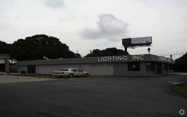
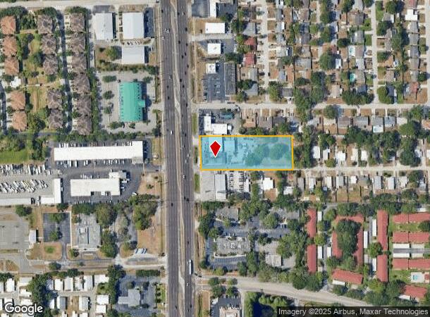
29703 Us Highway 19 N, Clearwater, FL 33761
NEARBY LISTINGS FOR SALE OR LEASE
Property Detail
29703 Us Highway 19 N
Tampa-St. Petersburg-Clearwater, FL
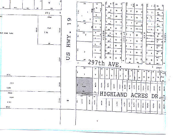
E 450Ft Of W 550Ft Of N
18-28-16-00000-430-0100
E 450FT OF W 550FT OF N 165FT OF S 330FT OF SE 1/4 OF SEC 18-28-16 SUBJ TO RD ESMT OVER S 15FT THEREOF PER DEED 1588/511
Vehiclerentalsvehiclesales
Pinellas
X
Florida
12103C0086G
1
2024
1.70 AC
2025
North Pinellas
026821
Tampa/St Petersburg
7,650 SF
DEMOGRAPHICS near 29703 Us Highway 19 N
1 Mile
3 Mile
5 Mile
2024 Total Population
12,376
100,753
203,304
2029 Population
12,341
100,607
202,589
Pop Growth 2024-2029
(0.28%)
(0.14%)
(0.35%)
Average Age
47
50
48
2024 Total Households
5,612
47,897
92,663
HH Growth 2024-2029
(0.50%)
(0.26%)
(0.47%)
Median Household Inc
$69,284
$61,564
$64,460
Avg Household Size
2.10
2.00
2.10
2024 Avg HH Vehicles
2.00
2.00
2.00
Median Home Value
$279,801
$280,152
$304,700
Median Year Built
1981
1982
1981
Nearby Places
Map Layers
Map Styles
 Street
 Aerial
- Restaurants
- Banks
- Shops
- Fitness
- Groceries
PUBLIC TRANSPORTATION
AIRPORT
St Pete-Clearwater International
DRIVE
WALK
Distance
St Pete-Clearwater International
29 min
15.7 mi
Tampa International
DRIVE
WALK
Distance
Tampa International
31 min
17.0 mi
Nearby Properties
Address
Land Use
TOTAL SIZE
Lot Size
Zoning
Address
Land Use
TOTAL SIZE
Lot Size
Zoning
661,982 SF
19.26 AC
Address
Land Use
TOTAL SIZE
Lot Size
Zoning
724,220 SF
22.95 AC
Address
Land Use
TOTAL SIZE
Lot Size
Zoning
462,206 SF
30.26 AC
RPD5
Address
Land Use
TOTAL SIZE
Lot Size
Zoning
460,041 SF
44.28 AC
Address
Land Use
TOTAL SIZE
Lot Size
Zoning
356,262 SF
15.48 AC
Address
Land Use
TOTAL SIZE
Lot Size
Zoning
167,201 SF
63.11 AC
AE
Address
Land Use
TOTAL SIZE
Lot Size
Zoning
406,729 SF
29.79 AC
CP1
Address
Land Use
TOTAL SIZE
Lot Size
Zoning
412,099 SF
49.21 AC
Address
Land Use
TOTAL SIZE
Lot Size
Zoning
326,008 SF
53.12 AC
Address
Land Use
TOTAL SIZE
Lot Size
Zoning
302,915 SF
55.33 AC
RPD75
Address
Land Use
TOTAL SIZE
Lot Size
Zoning
236,972 SF
19.07 AC
Address
Land Use
TOTAL SIZE
Lot Size
Zoning
286,650 SF
23.36 AC
RPD5
Address
Land Use
TOTAL SIZE
Lot Size
Zoning
311,117 SF
16.96 AC
Address
Land Use
TOTAL SIZE
Lot Size
Zoning
241,867 SF
19.54 AC
Address
Land Use
TOTAL SIZE
Lot Size
Zoning
242,708 SF
26.17 AC
RPD10
Address
Land Use
TOTAL SIZE
Lot Size
Zoning
233,620 SF
14.13 AC
RPD5
Address
Land Use
TOTAL SIZE
Lot Size
Zoning
304,142 SF
12.19 AC
RPD5
Address
Land Use
TOTAL SIZE
Lot Size
Zoning
239,480 SF
18.89 AC
RPD5
Address
Land Use
TOTAL SIZE
Lot Size
Zoning
258,403 SF
10.62 AC
RPD5
Address
Land Use
TOTAL SIZE
Lot Size
Zoning
215,081 SF
16.60 AC
Address
Land Use
TOTAL SIZE
Lot Size
Zoning
117,024 SF
56.52 AC
Address
Land Use
TOTAL SIZE
Lot Size
Zoning
161,404 SF
18.48 AC
CP2
Address
Land Use
TOTAL SIZE
Lot Size
Zoning
294,022 SF
15.75 AC
RPD5
Address
Land Use
TOTAL SIZE
Lot Size
Zoning
191,375 SF
13.58 AC
AE
Address
Land Use
TOTAL SIZE
Lot Size
Zoning
186,967 SF
16.86 AC
Address
Land Use
TOTAL SIZE
Lot Size
Zoning
199,825 SF
22.75 AC
R2
Address
Land Use
TOTAL SIZE
Lot Size
Zoning
151,398 SF
15.55 AC
CP1
Address
Land Use
TOTAL SIZE
Lot Size
Zoning
311,414 SF
15.59 AC
RPD75
Address
Land Use
TOTAL SIZE
Lot Size
Zoning
250,113 SF
39.50 AC
Address
Land Use
TOTAL SIZE
Lot Size
Zoning
145,000 SF
1.26 AC
The World's #1 Commercial Real Estate Marketplace
Connect with us
© 2025 CoStar Group
The information above has been obtained from sources believed reliable. While we do not doubt its accuracy we have not verified it and make no guarantee, warranty or representation about it. It is your responsibility to independently confirm its accuracy and completeness. Any projections, opinions, assumptions, or estimates used are for example only and do not represent the current or future performance of the property. The value of this transaction to you depends on tax and other factors which should be evaluated by your tax, financial, and legal advisors. You and your advisors should conduct a careful, independent investigation of the property to determine to your satisfaction the suitability of the property for your needs.