Property Record
2971 Ga Highway 247 Connector, Byron, GA 31008
NEARBY LISTINGS FOR SALE OR LEASE
Property Detail
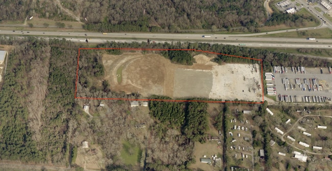
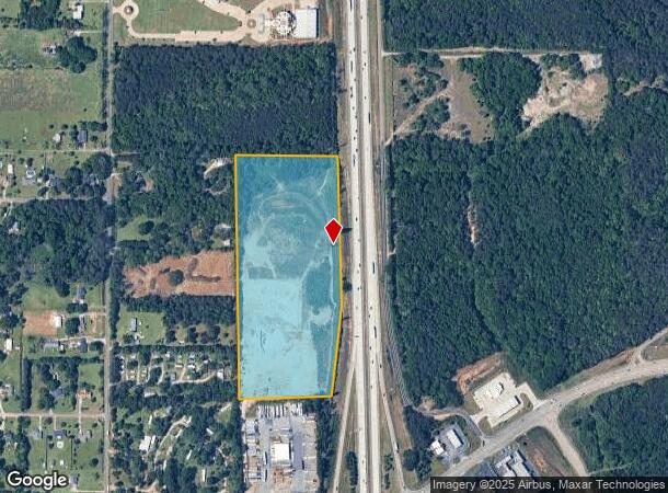
2971 Ga Highway 247 Connector
Warner Robins, GA
Ac: 50000.00
053D-073-A
21.149 AC \ ON INTERSTATE 75 LL 36 LD 5
Commercialacreage
Peach
A
Georgia
13225C0130C
36
2024
21.15 AC
2024
Perry/Warner Robins
040103
Other Market Areas
DEMOGRAPHICS near 2971 Ga Highway 247 Connector
1 Mile
3 Mile
5 Mile
2024 Total Population
1,305
19,273
56,206
2029 Population
1,370
20,693
60,787
Pop Growth 2024-2029
+ 4.98%
+ 7.37%
+ 8.15%
Average Age
42
40
39
2024 Total Households
541
7,719
21,782
HH Growth 2024-2029
+ 4.99%
+ 7.23%
+ 7.98%
Median Household Inc
$67,968
$75,785
$74,750
Avg Household Size
2.40
2.50
2.60
2024 Avg HH Vehicles
2.00
2.00
2.00
Median Home Value
$195,454
$173,732
$174,789
Median Year Built
2001
1999
1997
Nearby Places
Map Layers
Map Styles
 Street
 Aerial
- Restaurants
- Banks
- Shops
- Fitness
- Groceries
SALE & LEASE HISTORY
LISTING DATE
SALE/LEASE

Dec 07, 2020
For Sale
Apr 07, 2022
For Sale
Nearby Properties
Address
Land Use
TOTAL SIZE
Lot Size
Zoning
Address
Land Use
TOTAL SIZE
Lot Size
Zoning
27,504 SF
26.31 AC
PUD
Address
Land Use
TOTAL SIZE
Lot Size
Zoning
9,600 SF
24.25 AC
C-H
Address
Land Use
TOTAL SIZE
Lot Size
Zoning
68,545 SF
19.94 AC
MULTI
Address
Land Use
TOTAL SIZE
Lot Size
Zoning
15,006 SF
28 AC
PDE
Address
Land Use
TOTAL SIZE
Lot Size
Zoning
7,172 SF
24.73 AC
R4
Address
Land Use
TOTAL SIZE
Lot Size
Zoning
10,000 SF
1,163 AC
R-AG
Address
Land Use
TOTAL SIZE
Lot Size
Zoning
338,708 SF
28.28 AC
M-2
Address
Land Use
TOTAL SIZE
Lot Size
Zoning
18,954 SF
20 AC
C2
Address
Land Use
TOTAL SIZE
Lot Size
Zoning
63,274 SF
40.80 AC
C-2, WR
Address
Land Use
TOTAL SIZE
Lot Size
Zoning
56,260 SF
17.70 AC
C2
Address
Land Use
TOTAL SIZE
Lot Size
Zoning
5,320 SF
15.47 AC
R-4
Address
Land Use
TOTAL SIZE
Lot Size
Zoning
10,000 SF
43.93 AC
I-1
Address
Land Use
TOTAL SIZE
Lot Size
Zoning
94,274 SF
28.34 AC
R-AG
Address
Land Use
TOTAL SIZE
Lot Size
Zoning
60,300 SF
6.99 AC
M-2, WR
Address
Land Use
TOTAL SIZE
Lot Size
Zoning
84,909 SF
8.64 AC
C2
Address
Land Use
TOTAL SIZE
Lot Size
Zoning
80,825 SF
7.20 AC
I-1
Address
Land Use
TOTAL SIZE
Lot Size
Zoning
70,500 SF
18.47 AC
R1
Address
Land Use
TOTAL SIZE
Lot Size
Zoning
14,140 SF
16.59 AC
R1
Address
Land Use
TOTAL SIZE
Lot Size
Zoning
8,640 SF
12.49 AC
R-AG
Address
Land Use
TOTAL SIZE
Lot Size
Zoning
47,568 SF
1.51 AC
C-3
Address
Land Use
TOTAL SIZE
Lot Size
Zoning
35,841 SF
38.62 AC
RMH
Address
Land Use
TOTAL SIZE
Lot Size
Zoning
58,534 SF
7.82 AC
MULTI
Address
Land Use
TOTAL SIZE
Lot Size
Zoning
9,863 SF
11.85 AC
RR-1
Address
Land Use
TOTAL SIZE
Lot Size
Zoning
34,501 SF
6.82 AC
M2
Address
Land Use
TOTAL SIZE
Lot Size
Zoning
152.11 AC
PDE (WR)
Address
Land Use
TOTAL SIZE
Lot Size
Zoning
50,571 SF
2.02 AC
C2
Address
Land Use
TOTAL SIZE
Lot Size
Zoning
54.81 AC
C-2, WR
Address
Land Use
TOTAL SIZE
Lot Size
Zoning
35,004 SF
1.45 AC
C-3
Address
Land Use
TOTAL SIZE
Lot Size
Zoning
56,818 SF
4.18 AC
C2
Address
Land Use
TOTAL SIZE
Lot Size
Zoning
50,524 SF
3 AC
C2
The World's #1 Commercial Real Estate Marketplace
Connect with us
© 2025 CoStar Group
The information above has been obtained from sources believed reliable. While we do not doubt its accuracy we have not verified it and make no guarantee, warranty or representation about it. It is your responsibility to independently confirm its accuracy and completeness. Any projections, opinions, assumptions, or estimates used are for example only and do not represent the current or future performance of the property. The value of this transaction to you depends on tax and other factors which should be evaluated by your tax, financial, and legal advisors. You and your advisors should conduct a careful, independent investigation of the property to determine to your satisfaction the suitability of the property for your needs.