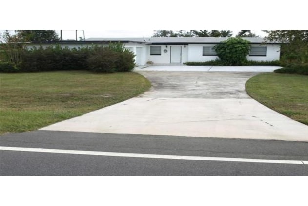
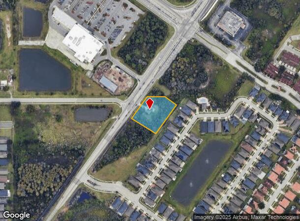
Property Record
2971 Simpson Rd, Kissimmee, FL 34744
NEARBY LISTINGS FOR SALE OR LEASE
Property Detail
2971 Simpson Rd
Orlando-Kissimmee-Sanford, FL
Acreage & Unrec
05-25-30-0000-0080-0000
Osceola
Sfr
Florida
X
1.05 AC
12095C0650G
Osceola Outlying
1,472 SF
Orlando
DEMOGRAPHICS near 2971 Simpson Rd
1 Mile
3 Mile
5 Mile
2024 Total Population
10,975
73,611
159,005
2029 Population
12,803
83,036
179,375
Pop Growth 2024-2029
+ 16.66%
+ 12.80%
+ 12.81%
Average Age
38
38
38
2024 Total Households
3,292
22,814
50,588
HH Growth 2024-2029
+ 16.59%
+ 12.83%
+ 12.93%
Median Household Inc
$72,471
$67,419
$66,576
Avg Household Size
3.30
3.10
3.10
2024 Avg HH Vehicles
2.00
2.00
2.00
Median Home Value
$312,630
$279,024
$286,790
Median Year Built
2007
1998
2001
Nearby Places
Map Layers
Map Styles
 Street
 Aerial
- Restaurants
- Banks
- Shops
- Fitness
- Groceries
PUBLIC TRANSPORTATION
COMMUTER RAIL
DRIVE
WALK
Distance
9 min
4.5 mi
DRIVE
WALK
Distance
11 min
6.5 mi
AIRPORT
Orlando International
DRIVE
WALK
Distance
Orlando International
14 min
8.6 mi
Orlando Sanford International
DRIVE
WALK
Distance
Orlando Sanford International
48 min
37.9 mi
SALE & LEASE HISTORY
LISTING DATE
SALE/LEASE

Mar 11, 2024
For Lease
Nearby Properties
Address
Land Use
TOTAL SIZE
Lot Size
Zoning
Address
Land Use
TOTAL SIZE
Lot Size
Zoning
422,767 SF
16.76 AC
P-D
Address
Land Use
TOTAL SIZE
Lot Size
Zoning
445,671 SF
20.03 AC
P-D
Address
Land Use
TOTAL SIZE
Lot Size
Zoning
337,649 SF
75.07 AC
OAC
Address
Land Use
TOTAL SIZE
Lot Size
Zoning
198,901 SF
22.68 AC
PD/AN
Address
Land Use
TOTAL SIZE
Lot Size
Zoning
288,459 SF
11.73 AC
P-D
Address
Land Use
TOTAL SIZE
Lot Size
Zoning
160,115 SF
25 AC
P-D
Address
Land Use
TOTAL SIZE
Lot Size
Zoning
110,091 SF
22.60 AC
PD/AN
Address
Land Use
TOTAL SIZE
Lot Size
Zoning
117,502 SF
8.71 AC
P-D
Address
Land Use
TOTAL SIZE
Lot Size
Zoning
93,674 SF
10.72 AC
P-D
Address
Land Use
TOTAL SIZE
Lot Size
Zoning
3,520 SF
90.25 AC
P-D
Address
Land Use
TOTAL SIZE
Lot Size
Zoning
165.89 AC
PD/AN
Address
Land Use
TOTAL SIZE
Lot Size
Zoning
94,100 SF
2.91 AC
P-D
Address
Land Use
TOTAL SIZE
Lot Size
Zoning
54.99 AC
P-D
Address
Land Use
TOTAL SIZE
Lot Size
Zoning
94,422 SF
11.23 AC
OPD
Address
Land Use
TOTAL SIZE
Lot Size
Zoning
58.99 AC
PD/AN
Address
Land Use
TOTAL SIZE
Lot Size
Zoning
88,788 SF
17.31 AC
P-D
Address
Land Use
TOTAL SIZE
Lot Size
Zoning
107,282 SF
1.99 AC
P-D
Address
Land Use
TOTAL SIZE
Lot Size
Zoning
67,745 SF
8.01 AC
P-D
Address
Land Use
TOTAL SIZE
Lot Size
Zoning
20,353 SF
65.61 AC
OPD
Address
Land Use
TOTAL SIZE
Lot Size
Zoning
10,353 SF
13.65 AC
P-D
Address
Land Use
TOTAL SIZE
Lot Size
Zoning
65,025 SF
14.78 AC
P-D
Address
Land Use
TOTAL SIZE
Lot Size
Zoning
85,734 SF
10.25 AC
P-D
Address
Land Use
TOTAL SIZE
Lot Size
Zoning
112,255 SF
16.31 AC
OPUD
Address
Land Use
TOTAL SIZE
Lot Size
Zoning
10,353 SF
U-ORG-P-D
Address
Land Use
TOTAL SIZE
Lot Size
Zoning
139,903 SF
13.32 AC
KRC1
Address
Land Use
TOTAL SIZE
Lot Size
Zoning
65,326 SF
9.51 AC
KB3
Address
Land Use
TOTAL SIZE
Lot Size
Zoning
81,525 SF
3.15 AC
Address
Land Use
TOTAL SIZE
Lot Size
Zoning
146,898 SF
15.24 AC
OPUD
Address
Land Use
TOTAL SIZE
Lot Size
Zoning
115,129 SF
15.01 AC
OPUD
Address
Land Use
TOTAL SIZE
Lot Size
Zoning
126,184 SF
25.33 AC
OPUD
The World's #1 Commercial Real Estate Marketplace
Connect with us
© 2025 CoStar Group
The information above has been obtained from sources believed reliable. While we do not doubt its accuracy we have not verified it and make no guarantee, warranty or representation about it. It is your responsibility to independently confirm its accuracy and completeness. Any projections, opinions, assumptions, or estimates used are for example only and do not represent the current or future performance of the property. The value of this transaction to you depends on tax and other factors which should be evaluated by your tax, financial, and legal advisors. You and your advisors should conduct a careful, independent investigation of the property to determine to your satisfaction the suitability of the property for your needs.