Property Record
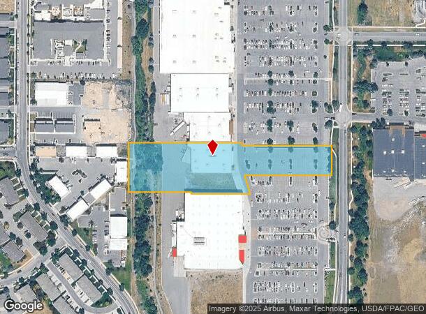
2975 Max Ave, Bozeman, MT 59718

NEARBY LISTINGS FOR SALE OR LEASE
Property Detail
2975 Max Ave
Bozeman, MT
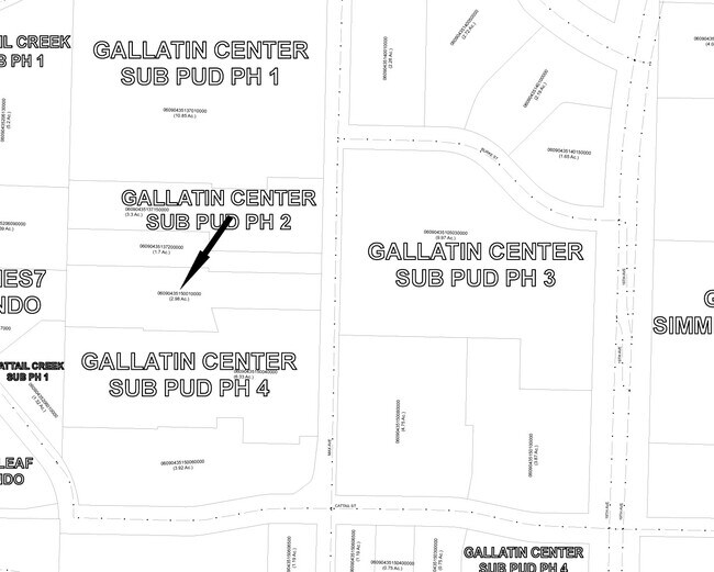
Gallatin Center Sub Pud Ph 4
06-0904-35-1-50-01-0000
GALLATIN CENTER SUB PUD PH 4, S35, T01 S, R05 E, BLOCK 1, LOT 12-A-1, ACRES 2.977, PLAT J-423-C
Storebuilding
Gallatin
X
Montana
30031C0804D
12-a-1
2025
2.98 AC
2025
Bozeman/Yellowstone Country
000507
Other Market Areas
20,454 SF
DEMOGRAPHICS near 2975 Max Ave
1 Mile
3 Mile
5 Mile
2024 Total Population
5,481
50,126
75,909
2029 Population
6,355
57,446
86,648
Pop Growth 2024-2029
+ 15.95%
+ 14.60%
+ 14.15%
Average Age
35
35
36
2024 Total Households
2,388
21,153
30,895
HH Growth 2024-2029
+ 16.42%
+ 15.32%
+ 15.01%
Median Household Inc
$102,708
$72,839
$79,957
Avg Household Size
2.30
2.20
2.30
2024 Avg HH Vehicles
2.00
2.00
2.00
Median Home Value
$698,412
$507,049
$610,308
Median Year Built
2010
2003
2002
Nearby Places
Map Layers
Map Styles
 Street
 Aerial
- Restaurants
- Banks
- Shops
- Fitness
- Groceries
PUBLIC TRANSPORTATION
AIRPORT
Bozeman Yellowstone International
DRIVE
WALK
Distance
Bozeman Yellowstone International
13 min
7.7 mi
Freight Ports
Port of Everett
DRIVE
WALK
Distance
Port of Everett
743 min
698.1 mi
Nearby Properties
Address
Land Use
TOTAL SIZE
Lot Size
Zoning
Address
Land Use
TOTAL SIZE
Lot Size
Zoning
138,308 SF
58.03 AC
Address
Land Use
TOTAL SIZE
Lot Size
Zoning
33,109 SF
9.89 AC
Address
Land Use
TOTAL SIZE
Lot Size
Zoning
89,441 SF
0.46 AC
6
Address
Land Use
TOTAL SIZE
Lot Size
Zoning
214,283 SF
5.20 AC
Address
Land Use
TOTAL SIZE
Lot Size
Zoning
6,317 SF
9.14 AC
Address
Land Use
TOTAL SIZE
Lot Size
Zoning
69,093 SF
8.96 AC
BP
Address
Land Use
TOTAL SIZE
Lot Size
Zoning
129,579 SF
9.74 AC
Address
Land Use
TOTAL SIZE
Lot Size
Zoning
10,368 SF
6.75 AC
Address
Land Use
TOTAL SIZE
Lot Size
Zoning
8,100 SF
64.73 AC
Address
Land Use
TOTAL SIZE
Lot Size
Zoning
33,771 SF
7.10 AC
Address
Land Use
TOTAL SIZE
Lot Size
Zoning
85,290 SF
7.82 AC
Address
Land Use
TOTAL SIZE
Lot Size
Zoning
81,620 SF
10.65 AC
1
Address
Land Use
TOTAL SIZE
Lot Size
Zoning
85,052 SF
1.26 AC
6
Address
Land Use
TOTAL SIZE
Lot Size
Zoning
69,917 SF
0.68 AC
6
Address
Land Use
TOTAL SIZE
Lot Size
Zoning
259,349 SF
B2
Address
Land Use
TOTAL SIZE
Lot Size
Zoning
20,106 SF
8.23 AC
Address
Land Use
TOTAL SIZE
Lot Size
Zoning
96,944 SF
0.44 AC
1
Address
Land Use
TOTAL SIZE
Lot Size
Zoning
149,599 SF
18.41 AC
Address
Land Use
TOTAL SIZE
Lot Size
Zoning
119,732 SF
7.32 AC
Address
Land Use
TOTAL SIZE
Lot Size
Zoning
19,938 SF
Address
Land Use
TOTAL SIZE
Lot Size
Zoning
27,219 SF
10.11 AC
R3
Address
Land Use
TOTAL SIZE
Lot Size
Zoning
128,745 SF
4.24 AC
Address
Land Use
TOTAL SIZE
Lot Size
Zoning
59,860 SF
42.94 AC
Address
Land Use
TOTAL SIZE
Lot Size
Zoning
94,146 SF
7.18 AC
R3
Address
Land Use
TOTAL SIZE
Lot Size
Zoning
122,580 SF
10.85 AC
Address
Land Use
TOTAL SIZE
Lot Size
Zoning
97,504 SF
0.56 AC
Address
Land Use
TOTAL SIZE
Lot Size
Zoning
173,255 SF
3.26 AC
Address
Land Use
TOTAL SIZE
Lot Size
Zoning
84,649 SF
Address
Land Use
TOTAL SIZE
Lot Size
Zoning
38,089 SF
1.23 AC
6
Address
Land Use
TOTAL SIZE
Lot Size
Zoning
93,211 SF
4.24 AC
The World's #1 Commercial Real Estate Marketplace
Connect with us
© 2025 CoStar Group
The information above has been obtained from sources believed reliable. While we do not doubt its accuracy we have not verified it and make no guarantee, warranty or representation about it. It is your responsibility to independently confirm its accuracy and completeness. Any projections, opinions, assumptions, or estimates used are for example only and do not represent the current or future performance of the property. The value of this transaction to you depends on tax and other factors which should be evaluated by your tax, financial, and legal advisors. You and your advisors should conduct a careful, independent investigation of the property to determine to your satisfaction the suitability of the property for your needs.