Property Record
2975 Partridge Rd, Saint Paul, MN 55113
Current Lease Availabilities
NEARBY LISTINGS FOR SALE OR LEASE
Property Detail
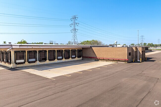
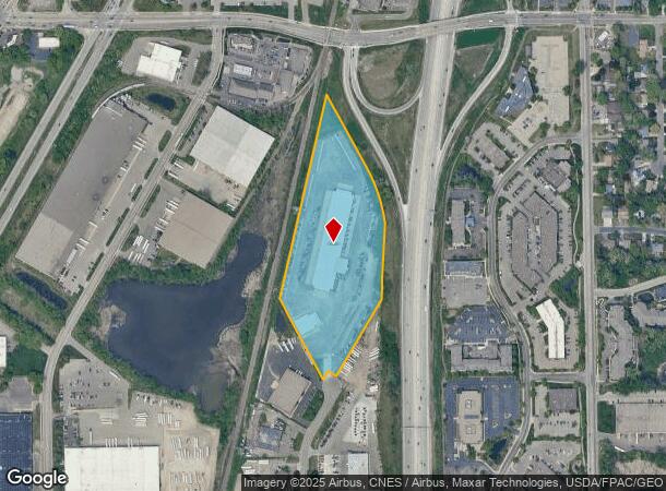
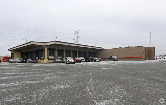
2975 Partridge Rd
Minneapolis-St. Paul-Bloomington, MN-WI
Partridge Industrial Park
05-29-23-11-0023
PARTRIDGE INDUSTRIAL PARK LOT 5 BLK 1
Truckterminal
Ramsey
X
Minnesota
27053C0240F
5
2024
10.62 AC
2025
North Central
041302
Minneapolis/St Paul
26,504 SF
DEMOGRAPHICS near 2975 Partridge Rd
1 Mile
3 Mile
5 Mile
2024 Total Population
8,859
83,967
274,992
2029 Population
8,686
82,593
271,460
Pop Growth 2024-2029
(1.95%)
(1.64%)
(1.28%)
Average Age
40
41
38
2024 Total Households
3,699
35,171
116,212
HH Growth 2024-2029
(2.03%)
(1.80%)
(1.39%)
Median Household Inc
$72,284
$81,620
$72,645
Avg Household Size
2.30
2.30
2.20
2024 Avg HH Vehicles
2.00
2.00
2.00
Median Home Value
$328,343
$317,487
$301,816
Median Year Built
1973
1966
1970
Nearby Places
- Restaurants
- Banks
- Shops
- Fitness
- Groceries
PUBLIC TRANSPORTATION
COMMUTER RAIL
Target Field Station (Northstar Corridor - Northstar Commuter Rail)
DRIVE
WALK
Distance
Target Field Station (Northstar Corridor - Northstar Commuter Rail)
14 min
8.0 mi
AIRPORT
Minneapolis-St Paul International/Wold-Chamberlain
DRIVE
WALK
Distance
Minneapolis-St Paul International/Wold-Chamberlain
26 min
14.8 mi
Nearby Properties
Address
Land Use
TOTAL SIZE
Lot Size
Zoning
Address
Land Use
TOTAL SIZE
Lot Size
Zoning
70,115 SF
191.32 AC
Address
Land Use
TOTAL SIZE
Lot Size
Zoning
37.24 AC
Address
Land Use
TOTAL SIZE
Lot Size
Zoning
Address
Land Use
TOTAL SIZE
Lot Size
Zoning
48.52 AC
Address
Land Use
TOTAL SIZE
Lot Size
Zoning
294,047 SF
7.99 AC
Address
Land Use
TOTAL SIZE
Lot Size
Zoning
142,933 SF
5.57 AC
Address
Land Use
TOTAL SIZE
Lot Size
Zoning
431,472 SF
7.04 AC
Address
Land Use
TOTAL SIZE
Lot Size
Zoning
476,695 SF
21.51 AC
Address
Land Use
TOTAL SIZE
Lot Size
Zoning
220 SF
19.66 AC
Address
Land Use
TOTAL SIZE
Lot Size
Zoning
462,598 SF
17.20 AC
I2
Address
Land Use
TOTAL SIZE
Lot Size
Zoning
658,453 SF
40.22 AC
Address
Land Use
TOTAL SIZE
Lot Size
Zoning
792 SF
42.69 AC
Address
Land Use
TOTAL SIZE
Lot Size
Zoning
2,296 SF
128.65 AC
Address
Land Use
TOTAL SIZE
Lot Size
Zoning
419,070 SF
45.50 AC
Address
Land Use
TOTAL SIZE
Lot Size
Zoning
167,511 SF
14.49 AC
Address
Land Use
TOTAL SIZE
Lot Size
Zoning
19,514 SF
70.59 AC
Address
Land Use
TOTAL SIZE
Lot Size
Zoning
255,096 SF
2.61 AC
Address
Land Use
TOTAL SIZE
Lot Size
Zoning
3.83 AC
Address
Land Use
TOTAL SIZE
Lot Size
Zoning
335,252 SF
19.06 AC
Address
Land Use
TOTAL SIZE
Lot Size
Zoning
21.94 AC
Address
Land Use
TOTAL SIZE
Lot Size
Zoning
294,500 SF
5.95 AC
Address
Land Use
TOTAL SIZE
Lot Size
Zoning
201,030 SF
7.59 AC
Address
Land Use
TOTAL SIZE
Lot Size
Zoning
170,875 SF
2.76 AC
Address
Land Use
TOTAL SIZE
Lot Size
Zoning
150,341 SF
12.86 AC
C3S
Address
Land Use
TOTAL SIZE
Lot Size
Zoning
393,252 SF
40 AC
Address
Land Use
TOTAL SIZE
Lot Size
Zoning
309,863 SF
56.34 AC
Address
Land Use
TOTAL SIZE
Lot Size
Zoning
6.11 AC
Address
Land Use
TOTAL SIZE
Lot Size
Zoning
27,175 SF
1.86 AC
Address
Land Use
TOTAL SIZE
Lot Size
Zoning
404,642 SF
15.97 AC
Address
Land Use
TOTAL SIZE
Lot Size
Zoning
599,778 SF
21.76 AC
I2
The World's #1 Commercial Real Estate Marketplace
Connect with us
© 2025 CoStar Group
The information above has been obtained from sources believed reliable. While we do not doubt its accuracy we have not verified it and make no guarantee, warranty or representation about it. It is your responsibility to independently confirm its accuracy and completeness. Any projections, opinions, assumptions, or estimates used are for example only and do not represent the current or future performance of the property. The value of this transaction to you depends on tax and other factors which should be evaluated by your tax, financial, and legal advisors. You and your advisors should conduct a careful, independent investigation of the property to determine to your satisfaction the suitability of the property for your needs.