Property Record
2975 Ramco St, West Sacramento, CA 95691


NEARBY LISTINGS FOR SALE OR LEASE
Property Detail
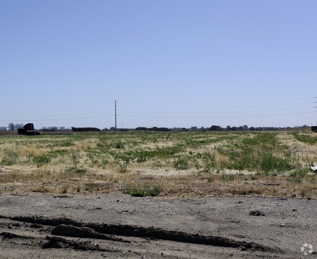
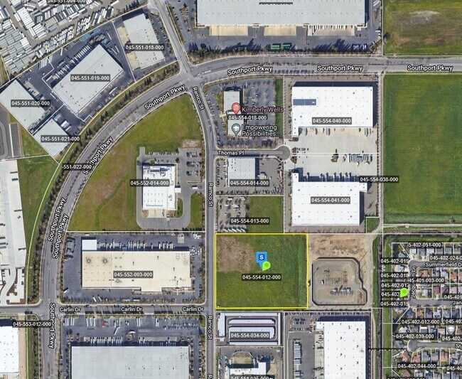
2975 Ramco St
Sacramento--Roseville--Arden-Arcade, CA
Southport Ind Park
045-554-013-000
COC 2023-0005282 RESULTANT PARCEL 1
Industrialgeneral
Yolo
ARE
California
06067C0170H
7
2023
10 AC
2025
West Sacramento
010203
Sacramento
DEMOGRAPHICS near 2975 Ramco St
1 Mile
3 Mile
5 Mile
2024 Total Population
7,020
48,911
178,834
2029 Population
7,132
49,606
181,222
Pop Growth 2024-2029
+ 1.60%
+ 1.42%
+ 1.34%
Average Age
37
38
40
2024 Total Households
2,455
18,239
76,215
HH Growth 2024-2029
+ 1.75%
+ 1.51%
+ 1.52%
Median Household Inc
$112,770
$89,539
$80,169
Avg Household Size
2.80
2.60
2.20
2024 Avg HH Vehicles
2.00
2.00
2.00
Median Home Value
$446,731
$485,015
$560,376
Median Year Built
2000
1986
1971
Nearby Places
Map Layers
Map Styles
 Street
 Aerial
- Restaurants
- Banks
- Shops
- Fitness
- Groceries
PUBLIC TRANSPORTATION
COMMUTER RAIL
Sacramento (Capitol Corridor - Capitol Corridor Joint Powers Authority)
DRIVE
WALK
Distance
Sacramento (Capitol Corridor - Capitol Corridor Joint Powers Authority)
12 min
5.5 mi
AIRPORT
Sacramento International
DRIVE
WALK
Distance
Sacramento International
26 min
16.4 mi
Freight Ports
Port of Stockton
DRIVE
WALK
Distance
Port of Stockton
61 min
49.6 mi
Nearby Properties
Address
Land Use
TOTAL SIZE
Lot Size
Zoning
Address
Land Use
TOTAL SIZE
Lot Size
Zoning
R-4-PUD C-
Address
Land Use
TOTAL SIZE
Lot Size
Zoning
110,584 SF
9.76 AC
B-P
Address
Land Use
TOTAL SIZE
Lot Size
Zoning
267,053 SF
22.19 AC
M2
Address
Land Use
TOTAL SIZE
Lot Size
Zoning
R-4-PUD
Address
Land Use
TOTAL SIZE
Lot Size
Zoning
379,161 SF
22.70 AC
MU
Address
Land Use
TOTAL SIZE
Lot Size
Zoning
181,432 SF
35.96 AC
MU
Address
Land Use
TOTAL SIZE
Lot Size
Zoning
253,713 SF
24.83 AC
M-L
Address
Land Use
TOTAL SIZE
Lot Size
Zoning
218,656 SF
0.08 AC
MU
Address
Land Use
TOTAL SIZE
Lot Size
Zoning
368,561 SF
24.69 AC
P-O
Address
Land Use
TOTAL SIZE
Lot Size
Zoning
260,285 SF
20.22 AC
C2
Address
Land Use
TOTAL SIZE
Lot Size
Zoning
27.65 AC
M-3
Address
Land Use
TOTAL SIZE
Lot Size
Zoning
229,130 SF
10.64 AC
BP
Address
Land Use
TOTAL SIZE
Lot Size
Zoning
222,937 SF
10.18 AC
HDR
Address
Land Use
TOTAL SIZE
Lot Size
Zoning
422,059 SF
22.62 AC
MU
Address
Land Use
TOTAL SIZE
Lot Size
Zoning
31.93 AC
M-3
Address
Land Use
TOTAL SIZE
Lot Size
Zoning
22.62 AC
BP
Address
Land Use
TOTAL SIZE
Lot Size
Zoning
387,420 SF
20.75 AC
MU
Address
Land Use
TOTAL SIZE
Lot Size
Zoning
209,088 SF
16.87 AC
M-L
Address
Land Use
TOTAL SIZE
Lot Size
Zoning
236,812 SF
12.12 AC
MU
Address
Land Use
TOTAL SIZE
Lot Size
Zoning
112,176 SF
1.05 AC
W-F
Address
Land Use
TOTAL SIZE
Lot Size
Zoning
444,600 SF
24.81 AC
MU
Address
Land Use
TOTAL SIZE
Lot Size
Zoning
474,792 SF
23.65 AC
MU
Address
Land Use
TOTAL SIZE
Lot Size
Zoning
1,849 SF
1.80 AC
M2
Address
Land Use
TOTAL SIZE
Lot Size
Zoning
216,425 SF
22.03 AC
C2
Address
Land Use
TOTAL SIZE
Lot Size
Zoning
5.65 AC
M-2
Address
Land Use
TOTAL SIZE
Lot Size
Zoning
302,598 SF
12.30 AC
M2
Address
Land Use
TOTAL SIZE
Lot Size
Zoning
115,234 SF
36.70 AC
M-3
Address
Land Use
TOTAL SIZE
Lot Size
Zoning
300,098 SF
15.79 AC
MU
Address
Land Use
TOTAL SIZE
Lot Size
Zoning
73,349 SF
1.82 AC
C2
Address
Land Use
TOTAL SIZE
Lot Size
Zoning
249,048 SF
12.48 AC
MU
The World's #1 Commercial Real Estate Marketplace
Connect with us
© 2025 CoStar Group
The information above has been obtained from sources believed reliable. While we do not doubt its accuracy we have not verified it and make no guarantee, warranty or representation about it. It is your responsibility to independently confirm its accuracy and completeness. Any projections, opinions, assumptions, or estimates used are for example only and do not represent the current or future performance of the property. The value of this transaction to you depends on tax and other factors which should be evaluated by your tax, financial, and legal advisors. You and your advisors should conduct a careful, independent investigation of the property to determine to your satisfaction the suitability of the property for your needs.