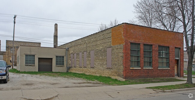
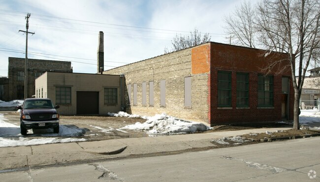
Property Record
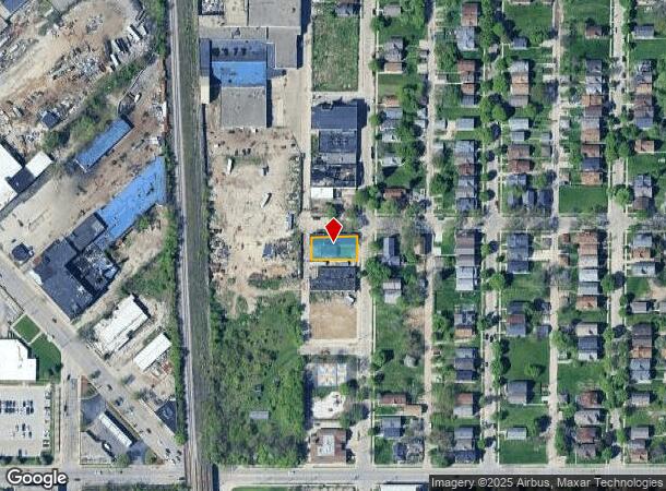
2979 N 30Th St, Milwaukee, WI 53210
NEARBY LISTINGS FOR SALE OR LEASE
Property Detail
2979 N 30Th St
Milwaukee-Waukesha-West Allis, WI
Fond Du Lac Avenue Addition
309-0638-100-8
FOND DU LAC AVENUE ADDITION OF LOTS 13 TO 35 INCL OF CAWKERS SUBD IN NE 1/4 SEC 13-7-21 BLOCK 4 LOTS 1 & 2 BID #37
Industrialgeneral
Milwaukee
X
Wisconsin
55079C0100E
13-35
2024
0.17 AC
2024
Milwaukee West
006300
Milwaukee/Madison
5,186 SF
DEMOGRAPHICS near 2979 N 30Th St
1 Mile
3 Mile
5 Mile
2024 Total Population
27,998
220,851
477,366
2029 Population
28,079
218,693
469,402
Pop Growth 2024-2029
+ 0.29%
(0.98%)
(1.67%)
Average Age
35
35
36
2024 Total Households
10,067
91,219
198,962
HH Growth 2024-2029
+ 0.08%
(1.10%)
(1.68%)
Median Household Inc
$30,942
$38,476
$47,360
Avg Household Size
2.60
2.30
2.30
2024 Avg HH Vehicles
1.00
1.00
1.00
Median Home Value
$70,735
$143,121
$180,655
Median Year Built
1946
1948
1949
Nearby Places
Map Layers
Map Styles
 Street
 Aerial
- Restaurants
- Banks
- Shops
- Fitness
- Groceries
PUBLIC TRANSPORTATION
COMMUTER RAIL
DRIVE
WALK
Distance
10 min
3.5 mi
AIRPORT
General Mitchell International
DRIVE
WALK
Distance
General Mitchell International
21 min
10.2 mi
SALE & LEASE HISTORY
LISTING DATE
SALE/LEASE

Aug 18, 2023
For Sale
Nearby Properties
Address
Land Use
TOTAL SIZE
Lot Size
Zoning
Address
Land Use
TOTAL SIZE
Lot Size
Zoning
8.05 AC
TL
Address
Land Use
TOTAL SIZE
Lot Size
Zoning
730,000 SF
6.94 AC
PD
Address
Land Use
TOTAL SIZE
Lot Size
Zoning
3.04 AC
TL
Address
Land Use
TOTAL SIZE
Lot Size
Zoning
280,000 SF
2.74 AC
RED
Address
Land Use
TOTAL SIZE
Lot Size
Zoning
378,717 SF
0.61 AC
C9D(A)
Address
Land Use
TOTAL SIZE
Lot Size
Zoning
491,759 SF
3 AC
C9F(A)
Address
Land Use
TOTAL SIZE
Lot Size
Zoning
382,921 SF
2.81 AC
PD
Address
Land Use
TOTAL SIZE
Lot Size
Zoning
180,407 SF
0.63 AC
PD
Address
Land Use
TOTAL SIZE
Lot Size
Zoning
210,552 SF
2.43 AC
C9D(A)
Address
Land Use
TOTAL SIZE
Lot Size
Zoning
508,168 SF
14.56 AC
C9G
Address
Land Use
TOTAL SIZE
Lot Size
Zoning
262,109 SF
2.24 AC
PD
Address
Land Use
TOTAL SIZE
Lot Size
Zoning
66,245 SF
10.21 AC
Address
Land Use
TOTAL SIZE
Lot Size
Zoning
2.92 AC
C9D(A)
Address
Land Use
TOTAL SIZE
Lot Size
Zoning
0.07 AC
RS6
Address
Land Use
TOTAL SIZE
Lot Size
Zoning
0.09 AC
LB2
Address
Land Use
TOTAL SIZE
Lot Size
Zoning
5.85 AC
C9D(A)
Address
Land Use
TOTAL SIZE
Lot Size
Zoning
356,540 SF
1.69 AC
C9D(A)
Address
Land Use
TOTAL SIZE
Lot Size
Zoning
247,344 SF
1.44 AC
RED
Address
Land Use
TOTAL SIZE
Lot Size
Zoning
685,390 SF
26.20 AC
Address
Land Use
TOTAL SIZE
Lot Size
Zoning
152,640 SF
10.50 AC
Address
Land Use
TOTAL SIZE
Lot Size
Zoning
150,370 SF
2.46 AC
C9G
Address
Land Use
TOTAL SIZE
Lot Size
Zoning
171,170 SF
25.88 AC
Address
Land Use
TOTAL SIZE
Lot Size
Zoning
12.74 AC
TL
Address
Land Use
TOTAL SIZE
Lot Size
Zoning
214,710 SF
0.67 AC
C9D(A)
Address
Land Use
TOTAL SIZE
Lot Size
Zoning
189,063 SF
2.35 AC
RED
Address
Land Use
TOTAL SIZE
Lot Size
Zoning
193,988 SF
1.28 AC
C9G
Address
Land Use
TOTAL SIZE
Lot Size
Zoning
5.67 AC
C9D(B)
Address
Land Use
TOTAL SIZE
Lot Size
Zoning
1 SF
6.43 AC
C9D(A)
Address
Land Use
TOTAL SIZE
Lot Size
Zoning
297,183 SF
1.37 AC
C9B(B)
Address
Land Use
TOTAL SIZE
Lot Size
Zoning
78,975 SF
1.83 AC
C9D(A)
The World's #1 Commercial Real Estate Marketplace
Connect with us
© 2025 CoStar Group
The information above has been obtained from sources believed reliable. While we do not doubt its accuracy we have not verified it and make no guarantee, warranty or representation about it. It is your responsibility to independently confirm its accuracy and completeness. Any projections, opinions, assumptions, or estimates used are for example only and do not represent the current or future performance of the property. The value of this transaction to you depends on tax and other factors which should be evaluated by your tax, financial, and legal advisors. You and your advisors should conduct a careful, independent investigation of the property to determine to your satisfaction the suitability of the property for your needs.