Property Record
298 Gratiot Blvd, Marysville, MI 48040
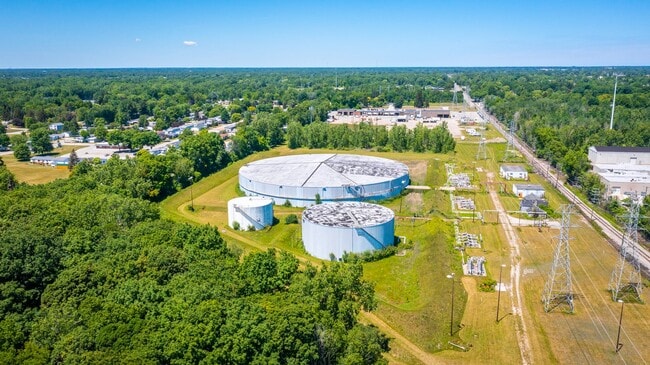
This Property Is For Sale
NEARBY LISTINGS FOR SALE OR LEASE
Property Detail
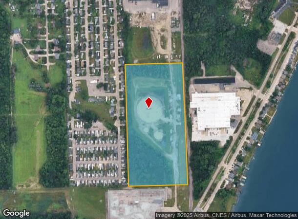
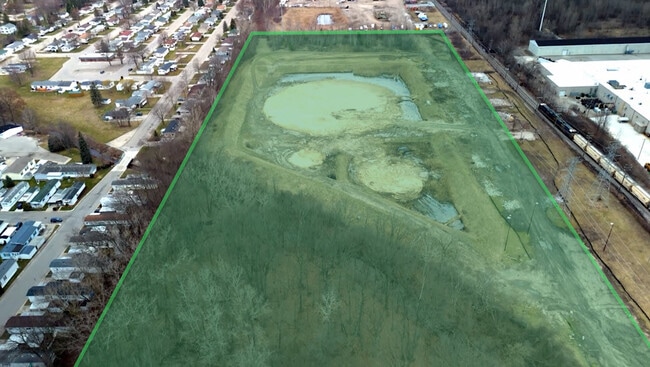
298 Gratiot Blvd
03-029-2005-010
BEG S 2D 23M 56S E 1250' FROM NE SEC COR, TH S 2D 23M 56S E 1434.03', TH S 88D 32M 23S W 691.57', TH N 1D 35M 46S W 1199.17', TH N 2D 7M 18S W 223.69', TH N 87D 36M 14S E 673.60' TO BEG SECTION 29 T6N R17E 22.35A
Officebuilding
St. Clair
X
Michigan
26147C0365D
22.35 AC
2025
St Clair & Lapeer Counties
2025
Detroit
637200
Detroit-Warren-Dearborn, MI
6,095 SF
DEMOGRAPHICS near 298 Gratiot Blvd
1 Mile
3 Mile
5 Mile
2024 Total Population
2,766
23,828
47,637
2029 Population
2,753
23,738
47,612
Pop Growth 2024-2029
(0.47%)
(0.38%)
(0.05%)
Average Age
43
39
40
2024 Total Households
1,161
9,350
19,348
HH Growth 2024-2029
(0.60%)
(0.52%)
(0.09%)
Median Household Inc
$45,298
$52,490
$50,458
Avg Household Size
2.20
2.40
2.40
2024 Avg HH Vehicles
2.00
2.00
2.00
Median Home Value
$118,562
$134,612
$140,956
Median Year Built
1973
1971
1968
Nearby Places
Map Layers
Map Styles
 Street
 Aerial
- Restaurants
- Banks
- Shops
- Fitness
- Groceries
PUBLIC TRANSPORTATION
COMMUTER RAIL
Port Huron Amtrak Station (Blue Water - Amtrak)
DRIVE
WALK
Distance
Port Huron Amtrak Station (Blue Water - Amtrak)
7 min
2.9 mi
Freight Ports
Port of Toledo
DRIVE
WALK
Distance
Port of Toledo
143 min
117.8 mi
Nearby Properties
Address
Land Use
TOTAL SIZE
Lot Size
Zoning
Address
Land Use
TOTAL SIZE
Lot Size
Zoning
206,565 SF
22.08 AC
I
Address
Land Use
TOTAL SIZE
Lot Size
Zoning
1,246,586 SF
83.70 AC
M-2
Address
Land Use
TOTAL SIZE
Lot Size
Zoning
204,347 SF
35.13 AC
C-2
Address
Land Use
TOTAL SIZE
Lot Size
Zoning
Address
Land Use
TOTAL SIZE
Lot Size
Zoning
134,379 SF
15 AC
RM-2
Address
Land Use
TOTAL SIZE
Lot Size
Zoning
115,172 SF
11.29 AC
A1
Address
Land Use
TOTAL SIZE
Lot Size
Zoning
173,584 SF
9.50 AC
M1
Address
Land Use
TOTAL SIZE
Lot Size
Zoning
80,662 SF
R1-A
Address
Land Use
TOTAL SIZE
Lot Size
Zoning
138,360 SF
6.01 AC
M-1
Address
Land Use
TOTAL SIZE
Lot Size
Zoning
149,732 SF
12.48 AC
M1
Address
Land Use
TOTAL SIZE
Lot Size
Zoning
109,097 SF
6.47 AC
A2
Address
Land Use
TOTAL SIZE
Lot Size
Zoning
137,720 SF
12.04 AC
B-3
Address
Land Use
TOTAL SIZE
Lot Size
Zoning
94,537 SF
12.63 AC
B-3
Address
Land Use
TOTAL SIZE
Lot Size
Zoning
77,868 SF
8.91 AC
RM-2
Address
Land Use
TOTAL SIZE
Lot Size
Zoning
73,882 SF
6.50 AC
B-3
Address
Land Use
TOTAL SIZE
Lot Size
Zoning
83,623 SF
5.49 AC
M-1
Address
Land Use
TOTAL SIZE
Lot Size
Zoning
140,230 SF
7.90 AC
M1
Address
Land Use
TOTAL SIZE
Lot Size
Zoning
85,200 SF
4.23 AC
M1
Address
Land Use
TOTAL SIZE
Lot Size
Zoning
45,750 SF
M1
Address
Land Use
TOTAL SIZE
Lot Size
Zoning
198,647 SF
26.04 AC
B-3
Address
Land Use
TOTAL SIZE
Lot Size
Zoning
168,310 SF
8.90 AC
M1
Address
Land Use
TOTAL SIZE
Lot Size
Zoning
118,606 SF
9.15 AC
A1
Address
Land Use
TOTAL SIZE
Lot Size
Zoning
105,269 SF
6 AC
M1
Address
Land Use
TOTAL SIZE
Lot Size
Zoning
81,940 SF
3.50 AC
M1
Address
Land Use
TOTAL SIZE
Lot Size
Zoning
86,480 SF
4.40 AC
M1
Address
Land Use
TOTAL SIZE
Lot Size
Zoning
70,020 SF
7.15 AC
M1
Address
Land Use
TOTAL SIZE
Lot Size
Zoning
69,440 SF
12.30 AC
C-2
Address
Land Use
TOTAL SIZE
Lot Size
Zoning
100,096 SF
13.85 AC
M-2
Address
Land Use
TOTAL SIZE
Lot Size
Zoning
61,855 SF
4.51 AC
M1
Address
Land Use
TOTAL SIZE
Lot Size
Zoning
74,984 SF
2.80 AC
A2
The World's #1 Commercial Real Estate Marketplace
Connect with us
© 2025 CoStar Group
The information above has been obtained from sources believed reliable. While we do not doubt its accuracy we have not verified it and make no guarantee, warranty or representation about it. It is your responsibility to independently confirm its accuracy and completeness. Any projections, opinions, assumptions, or estimates used are for example only and do not represent the current or future performance of the property. The value of this transaction to you depends on tax and other factors which should be evaluated by your tax, financial, and legal advisors. You and your advisors should conduct a careful, independent investigation of the property to determine to your satisfaction the suitability of the property for your needs.