Property Record
298 Reynolds Rd, Hiram, GA 30141
NEARBY LISTINGS FOR SALE OR LEASE
Property Detail
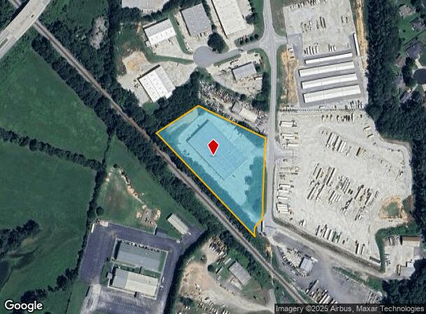
298 Reynolds Rd
Atlanta-Sandy Springs-Roswell, GA
REAL PROPERTY
178.1.1.005.0000
Paulding
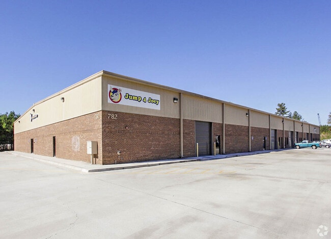
Warehouse
Georgia
2024
743
2024
3.20 AC
120603
I-20 W/Douglasville
35,000 SF
Atlanta
DEMOGRAPHICS near 298 Reynolds Rd
1 Mile
3 Mile
5 Mile
2024 Total Population
3,555
32,436
95,700
2029 Population
3,890
34,973
103,042
Pop Growth 2024-2029
+ 9.42%
+ 7.82%
+ 7.67%
Average Age
40
39
39
2024 Total Households
1,465
11,551
33,283
HH Growth 2024-2029
+ 9.97%
+ 8.13%
+ 7.95%
Median Household Inc
$76,174
$90,605
$91,515
Avg Household Size
2.40
2.80
2.80
2024 Avg HH Vehicles
2.00
2.00
2.00
Median Home Value
$263,127
$263,700
$264,470
Median Year Built
2000
1996
1995
Nearby Places
Map Layers
Map Styles
 Street
 Aerial
- Restaurants
- Banks
- Shops
- Fitness
- Groceries
PUBLIC TRANSPORTATION
AIRPORT
Hartsfield - Jackson Atlanta International
DRIVE
WALK
Distance
Hartsfield - Jackson Atlanta International
50 min
33.5 mi
Freight Ports
Georgia Ports - Savannah
DRIVE
WALK
Distance
Georgia Ports - Savannah
313 min
272.8 mi
SALE & LEASE HISTORY
LISTING DATE
SALE/LEASE

Sep 20, 2018
For Lease
Sep 06, 2019
For Sale
Nov 16, 2022
For Lease
Nov 08, 2017
For Lease
Dec 10, 2018
For Sale
Nearby Properties
Address
Land Use
TOTAL SIZE
Lot Size
Zoning
Address
Land Use
TOTAL SIZE
Lot Size
Zoning
69.17 AC
Address
Land Use
TOTAL SIZE
Lot Size
Zoning
18.80 AC
MXU
Address
Land Use
TOTAL SIZE
Lot Size
Zoning
9,882 SF
4.61 AC
CBD
Address
Land Use
TOTAL SIZE
Lot Size
Zoning
93.77 AC
Address
Land Use
TOTAL SIZE
Lot Size
Zoning
Address
Land Use
TOTAL SIZE
Lot Size
Zoning
15.02 AC
Address
Land Use
TOTAL SIZE
Lot Size
Zoning
171,510 SF
7.63 AC
MXU
Address
Land Use
TOTAL SIZE
Lot Size
Zoning
238,291 SF
22.51 AC
B2
Address
Land Use
TOTAL SIZE
Lot Size
Zoning
350,000 SF
24 AC
HI
Address
Land Use
TOTAL SIZE
Lot Size
Zoning
21.05 AC
Address
Land Use
TOTAL SIZE
Lot Size
Zoning
141,658 SF
17.36 AC
PSC
Address
Land Use
TOTAL SIZE
Lot Size
Zoning
Address
Land Use
TOTAL SIZE
Lot Size
Zoning
25.34 AC
Address
Land Use
TOTAL SIZE
Lot Size
Zoning
198,684 SF
21.35 AC
B2
Address
Land Use
TOTAL SIZE
Lot Size
Zoning
171,184 SF
14.63 AC
PSC
Address
Land Use
TOTAL SIZE
Lot Size
Zoning
133,006 SF
15.53 AC
PSC
Address
Land Use
TOTAL SIZE
Lot Size
Zoning
12,374 SF
1.42 AC
CBD
Address
Land Use
TOTAL SIZE
Lot Size
Zoning
67,341 SF
9.07 AC
GC
Address
Land Use
TOTAL SIZE
Lot Size
Zoning
101,340 SF
4.24 AC
CRC
Address
Land Use
TOTAL SIZE
Lot Size
Zoning
202,176 SF
24.10 AC
R-30
Address
Land Use
TOTAL SIZE
Lot Size
Zoning
185,183 SF
6.99 AC
OI
Address
Land Use
TOTAL SIZE
Lot Size
Zoning
103,185 SF
13.41 AC
B2
Address
Land Use
TOTAL SIZE
Lot Size
Zoning
367,298 SF
15.38 AC
LI
Address
Land Use
TOTAL SIZE
Lot Size
Zoning
86,556 SF
8.10 AC
PSC
Address
Land Use
TOTAL SIZE
Lot Size
Zoning
68,669 SF
7.95 AC
B1
Address
Land Use
TOTAL SIZE
Lot Size
Zoning
109,540 SF
13.99 AC
B2
Address
Land Use
TOTAL SIZE
Lot Size
Zoning
51,141 SF
4.93 AC
B1
Address
Land Use
TOTAL SIZE
Lot Size
Zoning
72,580 SF
7.05 AC
LI
Address
Land Use
TOTAL SIZE
Lot Size
Zoning
56,140 SF
8.24 AC
CRC
The World's #1 Commercial Real Estate Marketplace
Connect with us
© 2025 CoStar Group
The information above has been obtained from sources believed reliable. While we do not doubt its accuracy we have not verified it and make no guarantee, warranty or representation about it. It is your responsibility to independently confirm its accuracy and completeness. Any projections, opinions, assumptions, or estimates used are for example only and do not represent the current or future performance of the property. The value of this transaction to you depends on tax and other factors which should be evaluated by your tax, financial, and legal advisors. You and your advisors should conduct a careful, independent investigation of the property to determine to your satisfaction the suitability of the property for your needs.