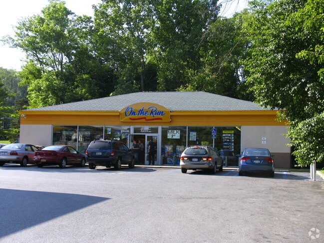
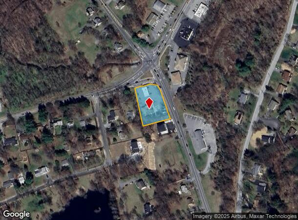
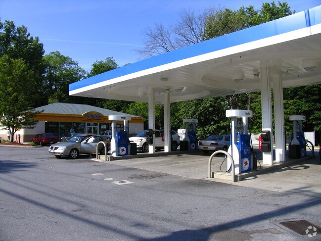
Property Record
298 Titusville Rd, Poughkeepsie, NY 12603
NEARBY LISTINGS FOR SALE OR LEASE
Property Detail
298 Titusville Rd
133400-6360-03-241471-0000
.93 AC
Servicestation
Dutchess
AE
New York
36027C0386E
241
2025
0.91 AC
2024
Fishkill
080201
Westchester/So Connecticut
1,917 SF
Dutchess County-Putnam County, NY
DEMOGRAPHICS near 298 Titusville Rd
1 Mile
3 Mile
5 Mile
2024 Total Population
3,099
23,766
86,643
2029 Population
3,090
23,835
86,766
Pop Growth 2024-2029
(0.29%)
+ 0.29%
+ 0.14%
Average Age
43
40
41
2024 Total Households
1,115
7,630
32,500
HH Growth 2024-2029
(0.36%)
+ 0.28%
+ 0.18%
Median Household Inc
$130,474
$121,272
$90,094
Avg Household Size
2.70
2.70
2.50
2024 Avg HH Vehicles
2.00
2.00
2.00
Median Home Value
$357,530
$365,995
$335,564
Median Year Built
1967
1968
1966
Nearby Places
Map Layers
Map Styles
 Street
 Aerial
- Restaurants
- Banks
- Shops
- Fitness
- Groceries
PUBLIC TRANSPORTATION
COMMUTER RAIL
Poughkeepsie Station (Hudson Line - Metro-North Commuter Railroad Company (Metro-North))
DRIVE
WALK
Distance
Poughkeepsie Station (Hudson Line - Metro-North Commuter Railroad Company (Metro-North))
11 min
6.4 mi
New Hamburg Station (Hudson Line - Metro-North Commuter Railroad Company (Metro-North))
DRIVE
WALK
Distance
New Hamburg Station (Hudson Line - Metro-North Commuter Railroad Company (Metro-North))
21 min
8.5 mi
AIRPORT
New York Stewart International
DRIVE
WALK
Distance
New York Stewart International
44 min
25.5 mi
Nearby Properties
Address
Land Use
TOTAL SIZE
Lot Size
Zoning
Address
Land Use
TOTAL SIZE
Lot Size
Zoning
1,279,884 SF
255.89 AC
IN
Address
Land Use
TOTAL SIZE
Lot Size
Zoning
247,216 SF
65.67 AC
RFD
Address
Land Use
TOTAL SIZE
Lot Size
Zoning
179,351 SF
18.34 AC
IN
Address
Land Use
TOTAL SIZE
Lot Size
Zoning
122,319 SF
23.12 AC
TCR
Address
Land Use
TOTAL SIZE
Lot Size
Zoning
121,040 SF
16.05 AC
OPD
Address
Land Use
TOTAL SIZE
Lot Size
Zoning
6.24 AC
I
Address
Land Use
TOTAL SIZE
Lot Size
Zoning
65,458 SF
11.60 AC
RFD
Address
Land Use
TOTAL SIZE
Lot Size
Zoning
70,830 SF
23.68 AC
R20
Address
Land Use
TOTAL SIZE
Lot Size
Zoning
512,000 SF
67 AC
AI
Address
Land Use
TOTAL SIZE
Lot Size
Zoning
510.80 AC
AI
Address
Land Use
TOTAL SIZE
Lot Size
Zoning
48,720 SF
12 AC
RMD
Address
Land Use
TOTAL SIZE
Lot Size
Zoning
3.24 AC
IN
Address
Land Use
TOTAL SIZE
Lot Size
Zoning
59,409 SF
34.17 AC
R20
Address
Land Use
TOTAL SIZE
Lot Size
Zoning
125,202 SF
11.20 AC
RMF5
Address
Land Use
TOTAL SIZE
Lot Size
Zoning
102,184 SF
24.28 AC
IN
Address
Land Use
TOTAL SIZE
Lot Size
Zoning
3.65 AC
RFD
Address
Land Use
TOTAL SIZE
Lot Size
Zoning
46,672 SF
24.43 AC
R20
Address
Land Use
TOTAL SIZE
Lot Size
Zoning
85,160 SF
20 AC
RFD
Address
Land Use
TOTAL SIZE
Lot Size
Zoning
62,452 SF
3 AC
R20
Address
Land Use
TOTAL SIZE
Lot Size
Zoning
228.33 AC
R-D
Address
Land Use
TOTAL SIZE
Lot Size
Zoning
67,842 SF
42.20 AC
R20
Address
Land Use
TOTAL SIZE
Lot Size
Zoning
205,300 SF
18.17 AC
GB
Address
Land Use
TOTAL SIZE
Lot Size
Zoning
124,095 SF
11.40 AC
RMF5
Address
Land Use
TOTAL SIZE
Lot Size
Zoning
22,947 SF
6.78 AC
R20
Address
Land Use
TOTAL SIZE
Lot Size
Zoning
92,016 SF
11 AC
IH
Address
Land Use
TOTAL SIZE
Lot Size
Zoning
48,600 SF
3.88 AC
TCB
Address
Land Use
TOTAL SIZE
Lot Size
Zoning
54,263 SF
8.51 AC
C
Address
Land Use
TOTAL SIZE
Lot Size
Zoning
27,204 SF
13.10 AC
R20
Address
Land Use
TOTAL SIZE
Lot Size
Zoning
46,800 SF
4.17 AC
IH
Address
Land Use
TOTAL SIZE
Lot Size
Zoning
200,000 SF
14.32 AC
C
The World's #1 Commercial Real Estate Marketplace
Connect with us
© 2025 CoStar Group
The information above has been obtained from sources believed reliable. While we do not doubt its accuracy we have not verified it and make no guarantee, warranty or representation about it. It is your responsibility to independently confirm its accuracy and completeness. Any projections, opinions, assumptions, or estimates used are for example only and do not represent the current or future performance of the property. The value of this transaction to you depends on tax and other factors which should be evaluated by your tax, financial, and legal advisors. You and your advisors should conduct a careful, independent investigation of the property to determine to your satisfaction the suitability of the property for your needs.