Property Record
298 W Butler Ave, Chalfont, PA 18914
NEARBY LISTINGS FOR SALE OR LEASE
Property Detail
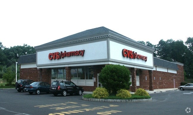
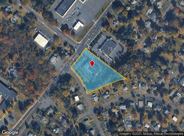
298 W Butler Ave
26-013-052
2.82AC LOT 1 SE COR US202 & BRITTANY DR 254 ON US202
Storebuilding
Bucks
X
Pennsylvania
42017C0289K
1
2024
2.82 AC
2025
Upper Bucks County
102004
Philadelphia
10,608 SF
Philadelphia-Camden-Wilmington, PA-NJ-DE-MD
DEMOGRAPHICS near 298 W Butler Ave
1 Mile
3 Mile
5 Mile
2024 Total Population
7,830
44,144
131,732
2029 Population
7,794
44,337
133,344
Pop Growth 2024-2029
(0.46%)
+ 0.44%
+ 1.22%
Average Age
42
42
42
2024 Total Households
3,053
15,819
48,888
HH Growth 2024-2029
(0.43%)
+ 0.44%
+ 1.25%
Median Household Inc
$111,351
$125,690
$108,465
Avg Household Size
2.50
2.70
2.60
2024 Avg HH Vehicles
2.00
2.00
2.00
Median Home Value
$397,955
$428,820
$421,312
Median Year Built
1979
1984
1981
Nearby Places
Map Layers
Map Styles
 Street
 Aerial
- Restaurants
- Banks
- Shops
- Fitness
- Groceries
PUBLIC TRANSPORTATION
TRANSIT/SUBWAY
Chalfont (R5 - Southeastern Pennsylvania Transportation Authority Regional Rail (SEPTA Regional Rail))
DRIVE
WALK
Distance
Chalfont (R5 - Southeastern Pennsylvania Transportation Authority Regional Rail (SEPTA Regional Rail))
3 min
20 min
1.0 mi
COMMUTER RAIL
Chalfont (R5 - Southeastern Pennsylvania Transportation Authority Regional Rail (SEPTA Regional Rail))
DRIVE
WALK
Distance
Chalfont (R5 - Southeastern Pennsylvania Transportation Authority Regional Rail (SEPTA Regional Rail))
3 min
19 min
1.0 mi
Link Belt (R5 - Southeastern Pennsylvania Transportation Authority Regional Rail (SEPTA Regional Rail))
DRIVE
WALK
Distance
Link Belt (R5 - Southeastern Pennsylvania Transportation Authority Regional Rail (SEPTA Regional Rail))
5 min
2.4 mi
AIRPORT
Trenton Mercer
DRIVE
WALK
Distance
Trenton Mercer
49 min
28.5 mi
Lehigh Valley International
DRIVE
WALK
Distance
Lehigh Valley International
56 min
33.9 mi
Philadelphia International
DRIVE
WALK
Distance
Philadelphia International
64 min
37.0 mi
Nearby Properties
Address
Land Use
TOTAL SIZE
Lot Size
Zoning
Address
Land Use
TOTAL SIZE
Lot Size
Zoning
245,104 SF
31.21 AC
C
Address
Land Use
TOTAL SIZE
Lot Size
Zoning
334,450 SF
18.86 AC
GA
Address
Land Use
TOTAL SIZE
Lot Size
Zoning
89,349 SF
18.11 AC
R1
Address
Land Use
TOTAL SIZE
Lot Size
Zoning
87,819 SF
1.82 AC
S
Address
Land Use
TOTAL SIZE
Lot Size
Zoning
119,740 SF
9.80 AC
BP
Address
Land Use
TOTAL SIZE
Lot Size
Zoning
136,473 SF
9.44 AC
LI
Address
Land Use
TOTAL SIZE
Lot Size
Zoning
88,060 SF
20.74 AC
R1
Address
Land Use
TOTAL SIZE
Lot Size
Zoning
77,805 SF
21.18 AC
R2
Address
Land Use
TOTAL SIZE
Lot Size
Zoning
134,272 SF
3.11 AC
S
Address
Land Use
TOTAL SIZE
Lot Size
Zoning
380,875 SF
40.10 AC
LI
Address
Land Use
TOTAL SIZE
Lot Size
Zoning
36,451 SF
22.94 AC
R2
Address
Land Use
TOTAL SIZE
Lot Size
Zoning
45,457 SF
6.32 AC
C
Address
Land Use
TOTAL SIZE
Lot Size
Zoning
79,335 SF
11.50 AC
LI
Address
Land Use
TOTAL SIZE
Lot Size
Zoning
361,858 SF
27.82 AC
LI
Address
Land Use
TOTAL SIZE
Lot Size
Zoning
68,854 SF
7.24 AC
C
Address
Land Use
TOTAL SIZE
Lot Size
Zoning
86,930 SF
1.76 AC
LI
Address
Land Use
TOTAL SIZE
Lot Size
Zoning
37,637 SF
4.60 AC
C
Address
Land Use
TOTAL SIZE
Lot Size
Zoning
5,856 SF
2.37 AC
LI
Address
Land Use
TOTAL SIZE
Lot Size
Zoning
134,704 SF
34.23 AC
PC1
Address
Land Use
TOTAL SIZE
Lot Size
Zoning
42,494 SF
11.19 AC
C
Address
Land Use
TOTAL SIZE
Lot Size
Zoning
6,152 SF
122.14 AC
R1
Address
Land Use
TOTAL SIZE
Lot Size
Zoning
65,000 SF
6.08 AC
LI
Address
Land Use
TOTAL SIZE
Lot Size
Zoning
67,790 SF
7.78 AC
S
Address
Land Use
TOTAL SIZE
Lot Size
Zoning
26,024 SF
3.29 AC
LI
Address
Land Use
TOTAL SIZE
Lot Size
Zoning
76,560 SF
11.51 AC
LI
Address
Land Use
TOTAL SIZE
Lot Size
Zoning
26,650 SF
3.66 AC
LI
Address
Land Use
TOTAL SIZE
Lot Size
Zoning
33,337 SF
14.88 AC
C3
Address
Land Use
TOTAL SIZE
Lot Size
Zoning
34,184 SF
3.91 AC
C
Address
Land Use
TOTAL SIZE
Lot Size
Zoning
32,964 SF
9.65 AC
BP
Address
Land Use
TOTAL SIZE
Lot Size
Zoning
28,160 SF
2.12 AC
LPO
The World's #1 Commercial Real Estate Marketplace
Connect with us
© 2025 CoStar Group
The information above has been obtained from sources believed reliable. While we do not doubt its accuracy we have not verified it and make no guarantee, warranty or representation about it. It is your responsibility to independently confirm its accuracy and completeness. Any projections, opinions, assumptions, or estimates used are for example only and do not represent the current or future performance of the property. The value of this transaction to you depends on tax and other factors which should be evaluated by your tax, financial, and legal advisors. You and your advisors should conduct a careful, independent investigation of the property to determine to your satisfaction the suitability of the property for your needs.