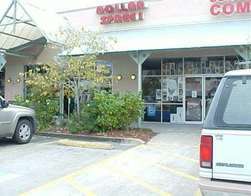
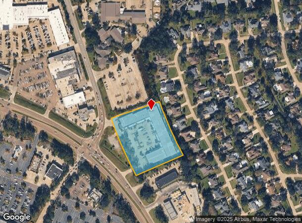
Property Record
2980 Highway 190, Mandeville, LA 70471
NEARBY LISTINGS FOR SALE OR LEASE
Property Detail
2980 Highway 190
50618
Commercial Hwy 190 Ward 4
Commercialnec
3.314 ACS SEC 34 38 7 11 CB 1466 386 INST NO 992130
ARE
St Tammany
2202020314D
Louisiana
2025
3.31 AC
2024
Mandeville/Covington
041207
New Orleans/Metairie/Kenner
50,112 SF
Slidell-Mandeville-Covington, LA
DEMOGRAPHICS near 2980 Highway 190
1 mile
3 mile
5 mile
2024 Total Population
8,010
43,626
74,273
2029 Population
8,566
46,740
79,577
Pop Growth 2024-2029
+ 6.94%
+ 7.14%
+ 7.14%
Average Age
43
42
41
2024 Total Households
3,152
16,925
29,116
HH Growth 2024-2029
+ 7.04%
+ 7.16%
+ 7.15%
Median Household Inc
$86,072
$82,303
$80,193
Avg Household Size
2.40
2.50
2.50
2024 Avg HH Vehicles
2.00
2.00
2.00
Median Home Value
$391,348
$339,265
$313,580
Median Year Built
1994
1993
1995
Nearby Places
Map Layers
Map Styles
 Street
 Aerial
Transit
 Traffic
 Biking
Places
Listings with unknown addresses are not visible on the map
- Restaurants
- Banks
- Shops
- Fitness
- Groceries
PUBLIC TRANSPORTATION
AIRPORT
Louis Armstrong New Orleans International
Drive
Walk
Distance
Louis Armstrong New Orleans International
49 min
36.1 mi
Freight Ports
Port of New Orleans
Drive
Walk
Distance
Port of New Orleans
54 min
37.1 mi
Nearby Properties
Address
Land Use
TOTAL SIZE
Lot Size
Zoning
Address
Land Use
TOTAL SIZE
Lot Size
Zoning
285,406 SF
Address
Land Use
TOTAL SIZE
Lot Size
Zoning
178,608 SF
34.02 AC
Address
Land Use
TOTAL SIZE
Lot Size
Zoning
285,048 SF
21.25 AC
Address
Land Use
TOTAL SIZE
Lot Size
Zoning
218,240 SF
23.82 AC
Address
Land Use
TOTAL SIZE
Lot Size
Zoning
268,040 SF
12.34 AC
Address
Land Use
TOTAL SIZE
Lot Size
Zoning
269,202 SF
13.66 AC
Address
Land Use
TOTAL SIZE
Lot Size
Zoning
266,213 SF
40 AC
Address
Land Use
TOTAL SIZE
Lot Size
Zoning
164,430 SF
6.32 AC
Address
Land Use
TOTAL SIZE
Lot Size
Zoning
229,994 SF
30 AC
Address
Land Use
TOTAL SIZE
Lot Size
Zoning
168,000 SF
10 AC
Address
Land Use
TOTAL SIZE
Lot Size
Zoning
220,860 SF
25.07 AC
Address
Land Use
TOTAL SIZE
Lot Size
Zoning
154,751 SF
14.96 AC
Address
Land Use
TOTAL SIZE
Lot Size
Zoning
165,168 SF
18.16 AC
Address
Land Use
TOTAL SIZE
Lot Size
Zoning
66,500 SF
4.35 AC
Address
Land Use
TOTAL SIZE
Lot Size
Zoning
156,183 SF
20 AC
Address
Land Use
TOTAL SIZE
Lot Size
Zoning
57,360 SF
2.77 AC
Address
Land Use
TOTAL SIZE
Lot Size
Zoning
147,457 SF
8.90 AC
Address
Land Use
TOTAL SIZE
Lot Size
Zoning
131,925 SF
2.02 AC
Address
Land Use
TOTAL SIZE
Lot Size
Zoning
2,053 SF
2 AC
Address
Land Use
TOTAL SIZE
Lot Size
Zoning
113,686 SF
10.34 AC
Address
Land Use
TOTAL SIZE
Lot Size
Zoning
54,226 SF
5.10 AC
Address
Land Use
TOTAL SIZE
Lot Size
Zoning
93,800 SF
10.35 AC
Address
Land Use
TOTAL SIZE
Lot Size
Zoning
206,403 SF
9.06 AC
Address
Land Use
TOTAL SIZE
Lot Size
Zoning
50,560 SF
6.32 AC
Address
Land Use
TOTAL SIZE
Lot Size
Zoning
185,093 SF
16.23 AC
Address
Land Use
TOTAL SIZE
Lot Size
Zoning
56,162 SF
5.30 AC
Address
Land Use
TOTAL SIZE
Lot Size
Zoning
48,866 SF
2.21 AC
Address
Land Use
TOTAL SIZE
Lot Size
Zoning
100,734 SF
23.66 AC
Address
Land Use
TOTAL SIZE
Lot Size
Zoning
77,388 SF
7.57 AC
Address
Land Use
TOTAL SIZE
Lot Size
Zoning
48,200 SF
1.95 AC
The World's #1 Commercial Real Estate Marketplace
Connect with us
© 2026 CoStar Group
The information above has been obtained from sources believed reliable. While we do not doubt its accuracy we have not verified it and make no guarantee, warranty or representation about it. It is your responsibility to independently confirm its accuracy and completeness. Any projections, opinions, assumptions, or estimates used are for example only and do not represent the current or future performance of the property. The value of this transaction to you depends on tax and other factors which should be evaluated by your tax, financial, and legal advisors. You and your advisors should conduct a careful, independent investigation of the property to determine to your satisfaction the suitability of the property for your needs.