Property Record
2980 Oneal Ln, Baton Rouge, LA 70816
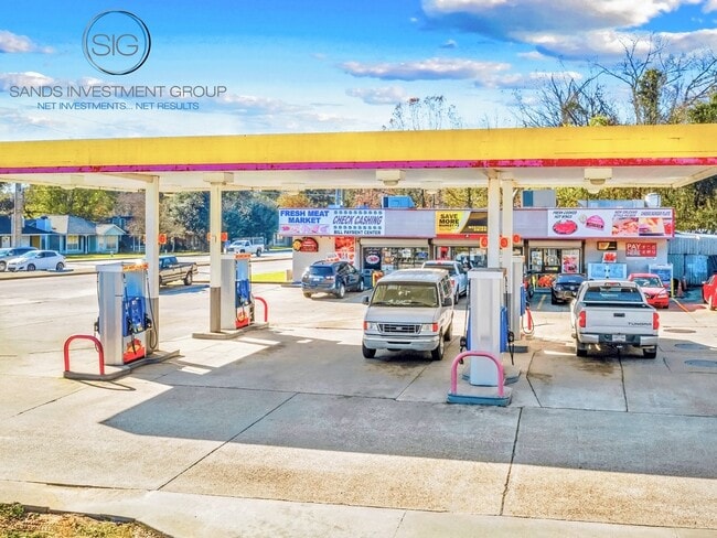


Property Detail
2980 Oneal Ln
Baton Rouge, LA
WARD: 1-4, SUBDIVISION: LIROCCHI, LOT: 1-A-2-A. LOT 1-A-2-A CONT. 0.60 ACRES RESUB. OF LOT 1-A-2. RESUB. 1984. LESS PARCEL 7-
00588296
East Baton Rouge
Storesoffices
Louisiana
2025
1-a-2-a
2025
0.60 AC
004511
Sherwood Forest
4,509 SF
Baton Rouge
NEARBY LISTINGS FOR SALE OR LEASE
DEMOGRAPHICS near 2980 Oneal Ln
1 mile
3 mile
5 mile
2025 Total Population
7,542
64,675
135,804
2030 Population
7,522
63,949
135,494
Pop Growth 2025-2030
(0.27%)
(1.12%)
(0.23%)
Average Age
36
38
39
2025 Total Households
2,915
25,560
53,949
HH Growth 2025-2030
(0.75%)
(1.28%)
(0.38%)
Median Household Inc
$82,179
$77,234
$74,050
Avg Household Size
2.50
2.50
2.40
2025 Avg HH Vehicles
2.00
2.00
2.00
Median Home Value
$264,799
$274,396
$259,805
Median Year Built
1994
1986
1985
Nearby Places
Map Layers
Map Styles
 Street
 Aerial
Layers
 Traffic
 Biking
Places
Listings with unknown addresses are not visible on the map
- Restaurants
- Banks
- Shops
- Fitness
- Groceries
PUBLIC TRANSPORTATION
AIRPORT
Baton Rouge Metro Ryan Field
Drive
Walk
Distance
Baton Rouge Metro Ryan Field
23 min
14.2 mi
Freight Ports
Port of Greater Baton Rouge
Drive
Walk
Distance
Port of Greater Baton Rouge
25 min
15.4 mi
SALE & LEASE HISTORY
LISTING DATE
SALE/LEASE

Jun 05, 2020
For Sale
Feb 19, 2020
For Sale
Nearby Properties
Address
Land Use
TOTAL SIZE
Lot Size
Zoning
Address
Land Use
TOTAL SIZE
Lot Size
Zoning
375,748 SF
25.58 AC
Address
Land Use
TOTAL SIZE
Lot Size
Zoning
742,463 SF
17.40 AC
Address
Land Use
TOTAL SIZE
Lot Size
Zoning
Address
Land Use
TOTAL SIZE
Lot Size
Zoning
481,760 SF
18.31 AC
Address
Land Use
TOTAL SIZE
Lot Size
Zoning
186,400 SF
9.13 AC
Address
Land Use
TOTAL SIZE
Lot Size
Zoning
Address
Land Use
TOTAL SIZE
Lot Size
Zoning
13.07 AC
Address
Land Use
TOTAL SIZE
Lot Size
Zoning
145,622 SF
25.07 AC
Address
Land Use
TOTAL SIZE
Lot Size
Zoning
Address
Land Use
TOTAL SIZE
Lot Size
Zoning
Address
Land Use
TOTAL SIZE
Lot Size
Zoning
Address
Land Use
TOTAL SIZE
Lot Size
Zoning
288,746 SF
12.16 AC
Address
Land Use
TOTAL SIZE
Lot Size
Zoning
257,282 SF
12.27 AC
Address
Land Use
TOTAL SIZE
Lot Size
Zoning
9.45 AC
Address
Land Use
TOTAL SIZE
Lot Size
Zoning
25.54 AC
Address
Land Use
TOTAL SIZE
Lot Size
Zoning
303,400 SF
25.16 AC
Address
Land Use
TOTAL SIZE
Lot Size
Zoning
112,314 SF
10.16 AC
Address
Land Use
TOTAL SIZE
Lot Size
Zoning
15.16 AC
Address
Land Use
TOTAL SIZE
Lot Size
Zoning
199,026 SF
19.52 AC
Address
Land Use
TOTAL SIZE
Lot Size
Zoning
341,964 SF
18.67 AC
Address
Land Use
TOTAL SIZE
Lot Size
Zoning
14.11 AC
Address
Land Use
TOTAL SIZE
Lot Size
Zoning
Address
Land Use
TOTAL SIZE
Lot Size
Zoning
252,000 SF
12.95 AC
Address
Land Use
TOTAL SIZE
Lot Size
Zoning
228,512 SF
9.77 AC
Address
Land Use
TOTAL SIZE
Lot Size
Zoning
14.31 AC
Address
Land Use
TOTAL SIZE
Lot Size
Zoning
54,637 SF
40.37 AC
Address
Land Use
TOTAL SIZE
Lot Size
Zoning
119,533 SF
2 AC
Address
Land Use
TOTAL SIZE
Lot Size
Zoning
Address
Land Use
TOTAL SIZE
Lot Size
Zoning
Address
Land Use
TOTAL SIZE
Lot Size
Zoning
70,300 SF
5.74 AC
The World's #1 Commercial Real Estate Marketplace
Connect with us
© 2026 CoStar Group
The information above has been obtained from sources believed reliable. While we do not doubt its accuracy we have not verified it and make no guarantee, warranty or representation about it. It is your responsibility to independently confirm its accuracy and completeness. Any projections, opinions, assumptions, or estimates used are for example only and do not represent the current or future performance of the property. The value of this transaction to you depends on tax and other factors which should be evaluated by your tax, financial, and legal advisors. You and your advisors should conduct a careful, independent investigation of the property to determine to your satisfaction the suitability of the property for your needs.