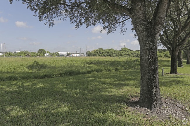
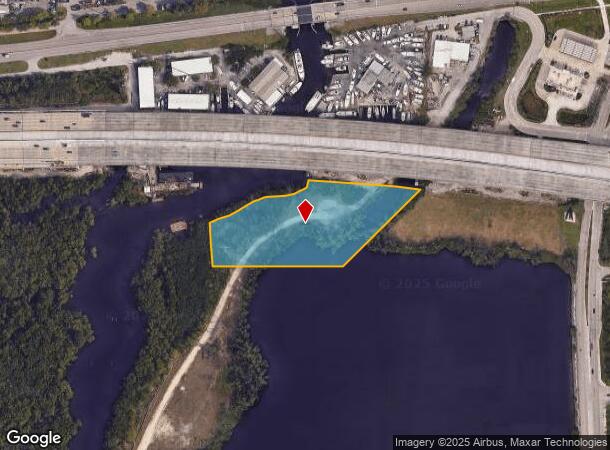
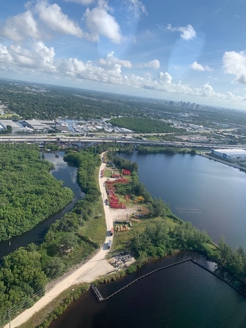
Property Record
2980 W State Road 84, Fort Lauderdale, FL 33312
NEARBY LISTINGS FOR SALE OR LEASE
Property Detail
2980 W State Road 84
Fort Lauderdale-Pompano Beach-Deerfield Beach, FL
2980 W STATE ROAD 84 183-577 B PARCEL C, PORTION LYING WITHIN THE CITY OF FORT LAUDERDALE
50-42-20-65-0030
Broward
Industrialacreage
Florida
2024
3.49 AC
2025
Fort Lauderdale
110600
South Florida
DEMOGRAPHICS near 2980 W State Road 84
1 Mile
3 Mile
5 Mile
2024 Total Population
4,243
100,093
350,506
2029 Population
4,284
102,169
360,599
Pop Growth 2024-2029
+ 0.97%
+ 2.07%
+ 2.88%
Average Age
43
39
40
2024 Total Households
1,745
37,105
138,012
HH Growth 2024-2029
+ 0.29%
+ 1.53%
+ 2.73%
Median Household Inc
$117,551
$76,546
$73,999
Avg Household Size
2.40
2.60
2.40
2024 Avg HH Vehicles
2.00
2.00
2.00
Median Home Value
$615,873
$476,058
$462,275
Median Year Built
1959
1969
1973
Nearby Places
Map Layers
Map Styles
 Street
 Aerial
- Restaurants
- Banks
- Shops
- Fitness
- Groceries
PUBLIC TRANSPORTATION
COMMUTER RAIL
Fort Lauderdale/Hollywood International Airport (Mangonia Park - Miami Airport - Tri-Rail, Tri-County Commuter - Tri-Rail, West Palm Beach - MiamiCentral - Tri-Rail)
DRIVE
WALK
Distance
Fort Lauderdale/Hollywood International Airport (Mangonia Park - Miami Airport - Tri-Rail, Tri-County Commuter - Tri-Rail, West Palm Beach - MiamiCentral - Tri-Rail)
8 min
3.3 mi
Fort Lauderdale (Tri-County Commuter - South Florida Regional Transportation Authority (Tri-Rail))
DRIVE
WALK
Distance
Fort Lauderdale (Tri-County Commuter - South Florida Regional Transportation Authority (Tri-Rail))
13 min
5.4 mi
AIRPORT
Fort Lauderdale/Hollywood International
DRIVE
WALK
Distance
Fort Lauderdale/Hollywood International
8 min
2.9 mi
Miami International
DRIVE
WALK
Distance
Miami International
48 min
29.8 mi
Freight Ports
Port Everglades
DRIVE
WALK
Distance
Port Everglades
8 min
3.7 mi
SALE & LEASE HISTORY
LISTING DATE
SALE/LEASE

Sep 24, 2016
For Sale
Feb 21, 2023
For Sale
Nearby Properties
Address
Land Use
TOTAL SIZE
Lot Size
Zoning
Address
Land Use
TOTAL SIZE
Lot Size
Zoning
4,515,106 SF
887.02 AC
AT
Address
Land Use
TOTAL SIZE
Lot Size
Zoning
4,212,940 SF
69.36 AC
N/A
Address
Land Use
TOTAL SIZE
Lot Size
Zoning
3,629,204 SF
159.43 AC
AT
Address
Land Use
TOTAL SIZE
Lot Size
Zoning
964,376 SF
258.71 AC
AT
Address
Land Use
TOTAL SIZE
Lot Size
Zoning
1,503,015 SF
13.03 AC
CF
Address
Land Use
TOTAL SIZE
Lot Size
Zoning
589,748 SF
27.34 AC
RAC-RTE
Address
Land Use
TOTAL SIZE
Lot Size
Zoning
550,907 SF
26.92 AC
RAC-RTE
Address
Land Use
TOTAL SIZE
Lot Size
Zoning
475,897 SF
14.91 AC
RAC-RTE
Address
Land Use
TOTAL SIZE
Lot Size
Zoning
409,340 SF
15.49 AC
RAC-RTE
Address
Land Use
TOTAL SIZE
Lot Size
Zoning
272,634 SF
32.39 AC
PMUD
Address
Land Use
TOTAL SIZE
Lot Size
Zoning
828,208 SF
44.48 AC
PMUD
Address
Land Use
TOTAL SIZE
Lot Size
Zoning
576,167 SF
27 AC
RAC-RTE
Address
Land Use
TOTAL SIZE
Lot Size
Zoning
416,469 SF
2.28 AC
M-PM
Address
Land Use
TOTAL SIZE
Lot Size
Zoning
278,398 SF
11.11 AC
RMM-25
Address
Land Use
TOTAL SIZE
Lot Size
Zoning
339,273 SF
20.48 AC
RM-16
Address
Land Use
TOTAL SIZE
Lot Size
Zoning
350,663 SF
16.86 AC
RAC-RTE
Address
Land Use
TOTAL SIZE
Lot Size
Zoning
296,691 SF
1.86 AC
PMUD
Address
Land Use
TOTAL SIZE
Lot Size
Zoning
356,053 SF
8.12 AC
RAC-RTE
Address
Land Use
TOTAL SIZE
Lot Size
Zoning
218,137 SF
7.13 AC
RM-2
Address
Land Use
TOTAL SIZE
Lot Size
Zoning
161,298 SF
31.25 AC
B-3
Address
Land Use
TOTAL SIZE
Lot Size
Zoning
262,844 SF
10.85 AC
B-FCC
Address
Land Use
TOTAL SIZE
Lot Size
Zoning
313,850 SF
0.80 AC
Address
Land Use
TOTAL SIZE
Lot Size
Zoning
312,636 SF
24.06 AC
I-G
Address
Land Use
TOTAL SIZE
Lot Size
Zoning
552,737 SF
11.76 AC
C-4
Address
Land Use
TOTAL SIZE
Lot Size
Zoning
327,948 SF
30.42 AC
CF-P
Address
Land Use
TOTAL SIZE
Lot Size
Zoning
217,019 SF
10.62 AC
B-2
Address
Land Use
TOTAL SIZE
Lot Size
Zoning
247,577 SF
39.47 AC
RAC-ED
Address
Land Use
TOTAL SIZE
Lot Size
Zoning
175,332 SF
4.05 AC
RAC-RTE
Address
Land Use
TOTAL SIZE
Lot Size
Zoning
285,942 SF
37.08 AC
CF
Address
Land Use
TOTAL SIZE
Lot Size
Zoning
480 SF
2.43 AC
PMUD-SL
The World's #1 Commercial Real Estate Marketplace
Connect with us
© 2025 CoStar Group
The information above has been obtained from sources believed reliable. While we do not doubt its accuracy we have not verified it and make no guarantee, warranty or representation about it. It is your responsibility to independently confirm its accuracy and completeness. Any projections, opinions, assumptions, or estimates used are for example only and do not represent the current or future performance of the property. The value of this transaction to you depends on tax and other factors which should be evaluated by your tax, financial, and legal advisors. You and your advisors should conduct a careful, independent investigation of the property to determine to your satisfaction the suitability of the property for your needs.