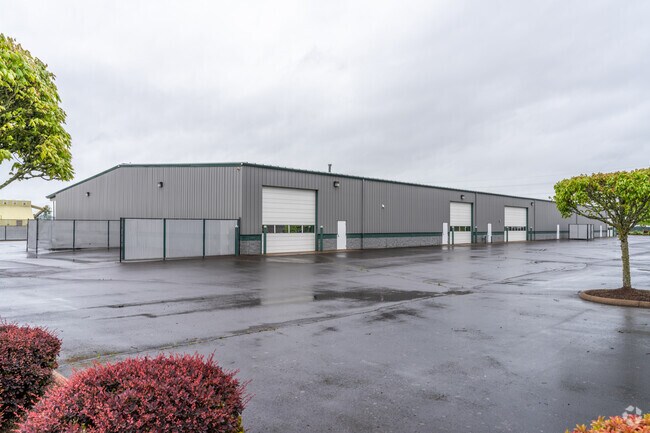
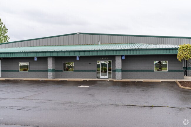
Property Record
29836 E Enid Rd, Eugene, OR 97402

Property Detail
29836 E Enid Rd
Eugene-Springfield, OR
SUBDIVISION PLAT EVANS SUBDIVISION LOT 1 TL 01100
1650223
Lane
Industrialgeneral
Oregon
I-2
1
A Areas with a 1% annual chance of flooding and a 26% chance of flooding over the life of a 30-year mortgage.
2.56 AC
2025
Lane County
2025
Portland
002403
NEARBY LISTINGS FOR SALE OR LEASE
DEMOGRAPHICS near 29836 E Enid Rd
1 mile
3 mile
5 mile
2024 Total Population
2,814
45,030
87,374
2029 Population
2,774
44,301
86,406
Pop Growth 2024-2029
(1.42%)
(1.62%)
(1.11%)
Average Age
45
42
42
2024 Total Households
1,109
17,354
34,207
HH Growth 2024-2029
(1.44%)
(1.71%)
(1.22%)
Median Household Inc
$88,652
$78,345
$76,139
Avg Household Size
2.50
2.50
2.40
2024 Avg HH Vehicles
2.00
2.00
2.00
Median Home Value
$440,389
$405,916
$413,319
Median Year Built
1993
1978
1980
Nearby Places
Map Layers
Map Styles
 Street
 Aerial
Transit
 Traffic
 Biking
Places
Listings with unknown addresses are not visible on the map
- Restaurants
- Banks
- Shops
- Fitness
- Groceries
PUBLIC TRANSPORTATION
COMMUTER RAIL
Eugene (Amtrak Cascades - Amtrak, Coast Starlight - Amtrak)
Drive
Walk
Distance
Eugene (Amtrak Cascades - Amtrak, Coast Starlight - Amtrak)
12 min
7.2 mi
AIRPORT
Mahlon Sweet Field
Drive
Walk
Distance
Mahlon Sweet Field
8 min
3.2 mi
Freight Ports
Port of Coos Bay, OR
Drive
Walk
Distance
Port of Coos Bay, OR
152 min
109.6 mi
SALE & LEASE HISTORY
LISTING DATE
SALE/LEASE

Jan 30, 2024
For Lease
Nearby Properties
Address
Land Use
TOTAL SIZE
Lot Size
Zoning
Address
Land Use
TOTAL SIZE
Lot Size
Zoning
Address
Land Use
TOTAL SIZE
Lot Size
Zoning
44.56 AC
PL
Address
Land Use
TOTAL SIZE
Lot Size
Zoning
480 SF
35.67 AC
AG
Address
Land Use
TOTAL SIZE
Lot Size
Zoning
664.30 AC
AO
Address
Land Use
TOTAL SIZE
Lot Size
Zoning
27.33 AC
M1
Address
Land Use
TOTAL SIZE
Lot Size
Zoning
121.21 AC
E40
Address
Land Use
TOTAL SIZE
Lot Size
Zoning
Address
Land Use
TOTAL SIZE
Lot Size
Zoning
Address
Land Use
TOTAL SIZE
Lot Size
Zoning
27.47 AC
R-1
Address
Land Use
TOTAL SIZE
Lot Size
Zoning
44.67 AC
I-2
Address
Land Use
TOTAL SIZE
Lot Size
Zoning
14.20 AC
R-1
Address
Land Use
TOTAL SIZE
Lot Size
Zoning
33.70 AC
R-1
Address
Land Use
TOTAL SIZE
Lot Size
Zoning
37.58 AC
PL
Address
Land Use
TOTAL SIZE
Lot Size
Zoning
Address
Land Use
TOTAL SIZE
Lot Size
Zoning
23.08 AC
PL
Address
Land Use
TOTAL SIZE
Lot Size
Zoning
Address
Land Use
TOTAL SIZE
Lot Size
Zoning
5.93 AC
C-2
Address
Land Use
TOTAL SIZE
Lot Size
Zoning
Address
Land Use
TOTAL SIZE
Lot Size
Zoning
2.82 AC
C-2
Address
Land Use
TOTAL SIZE
Lot Size
Zoning
8.13 AC
R-1
Address
Land Use
TOTAL SIZE
Lot Size
Zoning
31.30 AC
I-3
Address
Land Use
TOTAL SIZE
Lot Size
Zoning
4.62 AC
AG
Address
Land Use
TOTAL SIZE
Lot Size
Zoning
Address
Land Use
TOTAL SIZE
Lot Size
Zoning
Address
Land Use
TOTAL SIZE
Lot Size
Zoning
8.61 AC
C-2
Address
Land Use
TOTAL SIZE
Lot Size
Zoning
5.38 AC
I-2
Address
Land Use
TOTAL SIZE
Lot Size
Zoning
8.03 AC
C-2
Address
Land Use
TOTAL SIZE
Lot Size
Zoning
13.70 AC
AG
Address
Land Use
TOTAL SIZE
Lot Size
Zoning
Address
Land Use
TOTAL SIZE
Lot Size
Zoning
The World's #1 Commercial Real Estate Marketplace
Connect with us
© 2026 CoStar Group
The information above has been obtained from sources believed reliable. While we do not doubt its accuracy we have not verified it and make no guarantee, warranty or representation about it. It is your responsibility to independently confirm its accuracy and completeness. Any projections, opinions, assumptions, or estimates used are for example only and do not represent the current or future performance of the property. The value of this transaction to you depends on tax and other factors which should be evaluated by your tax, financial, and legal advisors. You and your advisors should conduct a careful, independent investigation of the property to determine to your satisfaction the suitability of the property for your needs.