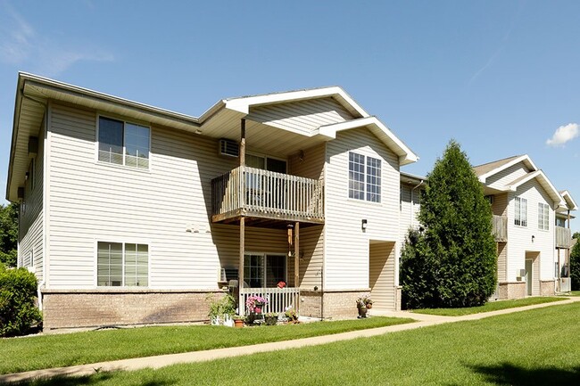
Property Record
29845 Cherry Hill Rd, Inkster, MI 48141


NEARBY LISTINGS FOR SALE OR LEASE
-
-
View all Inkster listings for sale on LoopNet.com
Property Detail
29845 Cherry Hill Rd
Detroit-Warren-Dearborn, MI
Grand View Gardens
44-001-99-0002-000
23B1A THE NORTH 460 FT OF THE EAST 165 FT OF THE NW 1/4 OF THE NE 1/4 OF SEC 23 EXCEPT THE NORTH 60.0 FT THEREOF 1.51 ACRES
Multifamilydwelling
Wayne
X
Michigan
26163C0240F
0002
2024
1.51 AC
2025
Inkster
570400
Detroit
35,770 SF
DEMOGRAPHICS near 29845 Cherry Hill Rd
1 Mile
3 Mile
5 Mile
2024 Total Population
15,453
119,956
273,771
2029 Population
14,934
115,616
263,299
Pop Growth 2024-2029
(3.36%)
(3.62%)
(3.83%)
Average Age
40
39
40
2024 Total Households
6,016
47,445
110,811
HH Growth 2024-2029
(3.44%)
(3.71%)
(3.87%)
Median Household Inc
$61,624
$57,737
$61,625
Avg Household Size
2.50
2.50
2.40
2024 Avg HH Vehicles
2.00
2.00
2.00
Median Home Value
$140,761
$153,632
$161,063
Median Year Built
1956
1958
1958
Nearby Places
Map Layers
Map Styles
 Street
 Aerial
- Restaurants
- Banks
- Shops
- Fitness
- Groceries
PUBLIC TRANSPORTATION
COMMUTER RAIL
DRIVE
WALK
Distance
15 min
6.6 mi
AIRPORT
Detroit Metro Wayne County
DRIVE
WALK
Distance
Detroit Metro Wayne County
19 min
9.5 mi
Windsor International
DRIVE
WALK
Distance
Windsor International
52 min
27.1 mi
Freight Ports
DRIVE
WALK
Distance
75 min
57.3 mi
Nearby Properties
Address
Land Use
TOTAL SIZE
Lot Size
Zoning
Address
Land Use
TOTAL SIZE
Lot Size
Zoning
176,396 SF
11.76 AC
Address
Land Use
TOTAL SIZE
Lot Size
Zoning
188,958 SF
7.71 AC
Address
Land Use
TOTAL SIZE
Lot Size
Zoning
206,130 SF
14.12 AC
Address
Land Use
TOTAL SIZE
Lot Size
Zoning
463,642 SF
22.82 AC
Address
Land Use
TOTAL SIZE
Lot Size
Zoning
197,774 SF
11.72 AC
Address
Land Use
TOTAL SIZE
Lot Size
Zoning
328,480 SF
11.54 AC
IA
Address
Land Use
TOTAL SIZE
Lot Size
Zoning
196,930 SF
9.93 AC
Address
Land Use
TOTAL SIZE
Lot Size
Zoning
166,030 SF
10.40 AC
Address
Land Use
TOTAL SIZE
Lot Size
Zoning
138,541 SF
8.65 AC
Address
Land Use
TOTAL SIZE
Lot Size
Zoning
99.86 AC
Address
Land Use
TOTAL SIZE
Lot Size
Zoning
149,735 SF
6.64 AC
Address
Land Use
TOTAL SIZE
Lot Size
Zoning
122,446 SF
6.75 AC
Address
Land Use
TOTAL SIZE
Lot Size
Zoning
142,269 SF
8.62 AC
Address
Land Use
TOTAL SIZE
Lot Size
Zoning
Address
Land Use
TOTAL SIZE
Lot Size
Zoning
132,779 SF
6.90 AC
Address
Land Use
TOTAL SIZE
Lot Size
Zoning
127,017 SF
6.91 AC
Address
Land Use
TOTAL SIZE
Lot Size
Zoning
176,883 SF
10.83 AC
Address
Land Use
TOTAL SIZE
Lot Size
Zoning
121,280 SF
6.86 AC
Address
Land Use
TOTAL SIZE
Lot Size
Zoning
171,414 SF
23.57 AC
Address
Land Use
TOTAL SIZE
Lot Size
Zoning
314,418 SF
28.06 AC
Address
Land Use
TOTAL SIZE
Lot Size
Zoning
103,706 SF
10.33 AC
Address
Land Use
TOTAL SIZE
Lot Size
Zoning
104,967 SF
6.67 AC
Address
Land Use
TOTAL SIZE
Lot Size
Zoning
53,263 SF
2.80 AC
Address
Land Use
TOTAL SIZE
Lot Size
Zoning
50,974 SF
8.48 AC
Address
Land Use
TOTAL SIZE
Lot Size
Zoning
125,389 SF
3.19 AC
Address
Land Use
TOTAL SIZE
Lot Size
Zoning
61,200 SF
10.10 AC
Address
Land Use
TOTAL SIZE
Lot Size
Zoning
110,371 SF
8.68 AC
Address
Land Use
TOTAL SIZE
Lot Size
Zoning
42,928 SF
4.88 AC
Address
Land Use
TOTAL SIZE
Lot Size
Zoning
111,699 SF
10.08 AC
Address
Land Use
TOTAL SIZE
Lot Size
Zoning
97,740 SF
4.47 AC
The World's #1 Commercial Real Estate Marketplace
Connect with us
© 2025 CoStar Group
The information above has been obtained from sources believed reliable. While we do not doubt its accuracy we have not verified it and make no guarantee, warranty or representation about it. It is your responsibility to independently confirm its accuracy and completeness. Any projections, opinions, assumptions, or estimates used are for example only and do not represent the current or future performance of the property. The value of this transaction to you depends on tax and other factors which should be evaluated by your tax, financial, and legal advisors. You and your advisors should conduct a careful, independent investigation of the property to determine to your satisfaction the suitability of the property for your needs.