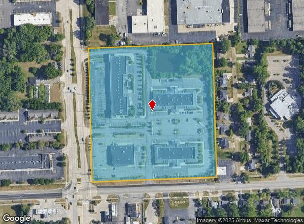
Property Record
2985 Crooks Rd, Rochester Hills, MI 48309
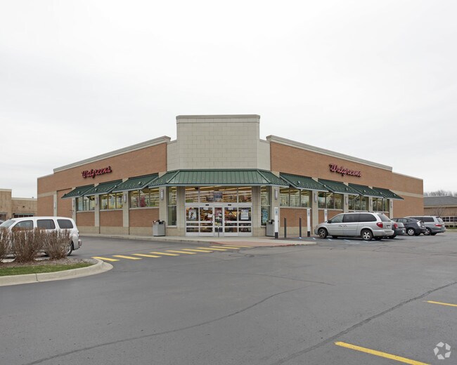


This Property Is For Sale
NEARBY LISTINGS FOR SALE OR LEASE
Property Detail
2985 Crooks Rd
Detroit-Warren-Dearborn, MI
Oakland County Condominium
15-28-353-001
Oakland
Condominium
Michigan
X
2.09 AC
26125C0393F
Rochester
14,820 SF
Detroit
DEMOGRAPHICS near 2985 Crooks Rd
1 Mile
3 Mile
5 Mile
2024 Total Population
6,615
62,447
181,464
2029 Population
6,553
61,870
180,032
Pop Growth 2024-2029
(0.94%)
(0.92%)
(0.79%)
Average Age
45
42
41
2024 Total Households
2,788
24,971
70,816
HH Growth 2024-2029
(1.00%)
(0.87%)
(0.77%)
Median Household Inc
$98,494
$105,993
$103,705
Avg Household Size
2.30
2.40
2.50
2024 Avg HH Vehicles
2.00
2.00
2.00
Median Home Value
$295,228
$347,974
$354,702
Median Year Built
1987
1982
1979
Nearby Places
- Restaurants
- Banks
- Shops
- Fitness
- Groceries
PUBLIC TRANSPORTATION
COMMUTER RAIL
Troy Amtrak Station (Wolverine - Amtrak)
DRIVE
WALK
Distance
Troy Amtrak Station (Wolverine - Amtrak)
15 min
7.9 mi
Pontiac Amtrak Station (Wolverine - Amtrak)
DRIVE
WALK
Distance
Pontiac Amtrak Station (Wolverine - Amtrak)
13 min
8.1 mi
AIRPORT
Windsor International
DRIVE
WALK
Distance
Windsor International
53 min
34.1 mi
Freight Ports
Port of Toledo
DRIVE
WALK
Distance
Port of Toledo
104 min
84.6 mi
Nearby Properties
Address
Land Use
TOTAL SIZE
Lot Size
Zoning
Address
Land Use
TOTAL SIZE
Lot Size
Zoning
3,529 SF
29.19 AC
BI
Address
Land Use
TOTAL SIZE
Lot Size
Zoning
453,700 SF
Address
Land Use
TOTAL SIZE
Lot Size
Zoning
404,427 SF
28.15 AC
TR
Address
Land Use
TOTAL SIZE
Lot Size
Zoning
337,992 SF
18.96 AC
TR
Address
Land Use
TOTAL SIZE
Lot Size
Zoning
104,434 SF
8.64 AC
Address
Land Use
TOTAL SIZE
Lot Size
Zoning
Address
Land Use
TOTAL SIZE
Lot Size
Zoning
288,288 SF
15 AC
Address
Land Use
TOTAL SIZE
Lot Size
Zoning
331,412 SF
24.25 AC
O1
Address
Land Use
TOTAL SIZE
Lot Size
Zoning
144,450 SF
11.22 AC
OSC
Address
Land Use
TOTAL SIZE
Lot Size
Zoning
144,450 SF
11.22 AC
Address
Land Use
TOTAL SIZE
Lot Size
Zoning
210,000 SF
14.46 AC
TR
Address
Land Use
TOTAL SIZE
Lot Size
Zoning
337,992 SF
Address
Land Use
TOTAL SIZE
Lot Size
Zoning
245,371 SF
19.76 AC
RC
Address
Land Use
TOTAL SIZE
Lot Size
Zoning
136,962 SF
43.80 AC
OSC
Address
Land Use
TOTAL SIZE
Lot Size
Zoning
14.48 AC
Address
Land Use
TOTAL SIZE
Lot Size
Zoning
321,936 SF
29.11 AC
RM1
Address
Land Use
TOTAL SIZE
Lot Size
Zoning
64,217 SF
39.13 AC
Address
Land Use
TOTAL SIZE
Lot Size
Zoning
209,596 SF
Address
Land Use
TOTAL SIZE
Lot Size
Zoning
209,596 SF
9.16 AC
TR
Address
Land Use
TOTAL SIZE
Lot Size
Zoning
336,720 SF
63.11 AC
CR1
Address
Land Use
TOTAL SIZE
Lot Size
Zoning
22.09 AC
AI
Address
Land Use
TOTAL SIZE
Lot Size
Zoning
Address
Land Use
TOTAL SIZE
Lot Size
Zoning
218,155 SF
20.98 AC
RC
Address
Land Use
TOTAL SIZE
Lot Size
Zoning
21.52 AC
AI
Address
Land Use
TOTAL SIZE
Lot Size
Zoning
19.86 AC
AI
Address
Land Use
TOTAL SIZE
Lot Size
Zoning
88,734 SF
17.78 AC
Address
Land Use
TOTAL SIZE
Lot Size
Zoning
142,580 SF
14.26 AC
RC
The World's #1 Commercial Real Estate Marketplace
Connect with us
© 2025 CoStar Group
The information above has been obtained from sources believed reliable. While we do not doubt its accuracy we have not verified it and make no guarantee, warranty or representation about it. It is your responsibility to independently confirm its accuracy and completeness. Any projections, opinions, assumptions, or estimates used are for example only and do not represent the current or future performance of the property. The value of this transaction to you depends on tax and other factors which should be evaluated by your tax, financial, and legal advisors. You and your advisors should conduct a careful, independent investigation of the property to determine to your satisfaction the suitability of the property for your needs.