Property Record
2985 Highway 367 N, Austin, AR 72007
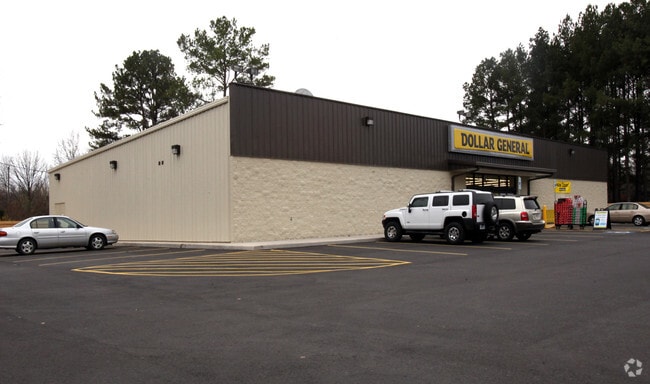

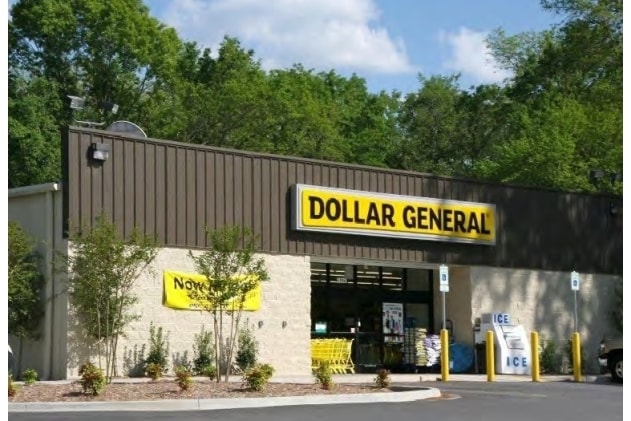
Property Detail
2985 Highway 367 N
710-20001-000
LONOKE
Storebuilding
Arkansas
B and X Area of moderate flood hazard, usually the area between the limits of the 100-year and 500-year floods.
1
2023
0.82 AC
2025
Lonoke County
020202
Little Rock/N Little Rock
9,230 SF
Little Rock-North Little Rock-Conway, AR
NEARBY LISTINGS FOR SALE OR LEASE
-
-
View all Austin listings for sale on LoopNet.com
DEMOGRAPHICS near 2985 Highway 367 N
1 mile
3 mile
5 mile
2025 Total Population
2,080
21,572
44,061
2030 Population
2,137
22,149
45,110
Pop Growth 2025-2030
+ 2.74%
+ 2.67%
+ 2.38%
Average Age
37
38
38
2025 Total Households
748
8,019
16,302
HH Growth 2025-2030
+ 2.81%
+ 2.73%
+ 2.44%
Median Household Inc
$90,135
$81,379
$82,309
Avg Household Size
2.70
2.60
2.70
2025 Avg HH Vehicles
2.00
2.00
2.00
Median Home Value
$227,419
$191,130
$199,029
Median Year Built
2005
2000
2000
Nearby Places
Map Layers
Map Styles
 Street
 Aerial
Transit
 Traffic
 Biking
Places
Listings with unknown addresses are not visible on the map
- Restaurants
- Banks
- Shops
- Fitness
- Groceries
PUBLIC TRANSPORTATION
AIRPORT
Bill and Hillary Clinton Ntl/Adams Field
Drive
Walk
Distance
Bill and Hillary Clinton Ntl/Adams Field
33 min
28.4 mi
Freight Ports
Port of Shreveport
Drive
Walk
Distance
Port of Shreveport
279 min
259.4 mi
Nearby Properties
Address
Land Use
TOTAL SIZE
Lot Size
Zoning
Address
Land Use
TOTAL SIZE
Lot Size
Zoning
44,884 SF
9.65 AC
Address
Land Use
TOTAL SIZE
Lot Size
Zoning
23,603 SF
0.70 AC
Address
Land Use
TOTAL SIZE
Lot Size
Zoning
141,490 SF
9.97 AC
Address
Land Use
TOTAL SIZE
Lot Size
Zoning
13,302 SF
0.71 AC
Address
Land Use
TOTAL SIZE
Lot Size
Zoning
50,550 SF
8.98 AC
Address
Land Use
TOTAL SIZE
Lot Size
Zoning
104,795 SF
12.07 AC
Address
Land Use
TOTAL SIZE
Lot Size
Zoning
139,126 SF
10 AC
Address
Land Use
TOTAL SIZE
Lot Size
Zoning
51,992 SF
2.82 AC
Address
Land Use
TOTAL SIZE
Lot Size
Zoning
67,672 SF
5.23 AC
Address
Land Use
TOTAL SIZE
Lot Size
Zoning
91,224 SF
8.39 AC
Address
Land Use
TOTAL SIZE
Lot Size
Zoning
32,438 SF
7.40 AC
Address
Land Use
TOTAL SIZE
Lot Size
Zoning
9,750 SF
1.62 AC
Address
Land Use
TOTAL SIZE
Lot Size
Zoning
41,864 SF
5.22 AC
Address
Land Use
TOTAL SIZE
Lot Size
Zoning
16,426 SF
3.21 AC
Address
Land Use
TOTAL SIZE
Lot Size
Zoning
18,550 SF
11.37 AC
Address
Land Use
TOTAL SIZE
Lot Size
Zoning
83,775 SF
2.04 AC
Address
Land Use
TOTAL SIZE
Lot Size
Zoning
39,800 SF
9.94 AC
Address
Land Use
TOTAL SIZE
Lot Size
Zoning
15,900 SF
2.11 AC
Address
Land Use
TOTAL SIZE
Lot Size
Zoning
11,683 SF
0.58 AC
Address
Land Use
TOTAL SIZE
Lot Size
Zoning
8,450 SF
0.62 AC
Address
Land Use
TOTAL SIZE
Lot Size
Zoning
55,587 SF
3 AC
Address
Land Use
TOTAL SIZE
Lot Size
Zoning
31,919 SF
4.15 AC
Address
Land Use
TOTAL SIZE
Lot Size
Zoning
8,700 SF
0.44 AC
Address
Land Use
TOTAL SIZE
Lot Size
Zoning
7,288 SF
3.13 AC
Address
Land Use
TOTAL SIZE
Lot Size
Zoning
23,784 SF
1.01 AC
Address
Land Use
TOTAL SIZE
Lot Size
Zoning
23,874 SF
3.01 AC
Address
Land Use
TOTAL SIZE
Lot Size
Zoning
17,416 SF
2.23 AC
Address
Land Use
TOTAL SIZE
Lot Size
Zoning
26,144 SF
10.09 AC
Address
Land Use
TOTAL SIZE
Lot Size
Zoning
38,223 SF
3.40 AC
Address
Land Use
TOTAL SIZE
Lot Size
Zoning
18,600 SF
The World's #1 Commercial Real Estate Marketplace
Connect with us
© 2026 CoStar Group
The information above has been obtained from sources believed reliable. While we do not doubt its accuracy we have not verified it and make no guarantee, warranty or representation about it. It is your responsibility to independently confirm its accuracy and completeness. Any projections, opinions, assumptions, or estimates used are for example only and do not represent the current or future performance of the property. The value of this transaction to you depends on tax and other factors which should be evaluated by your tax, financial, and legal advisors. You and your advisors should conduct a careful, independent investigation of the property to determine to your satisfaction the suitability of the property for your needs.