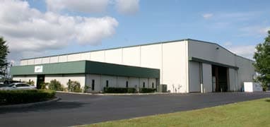
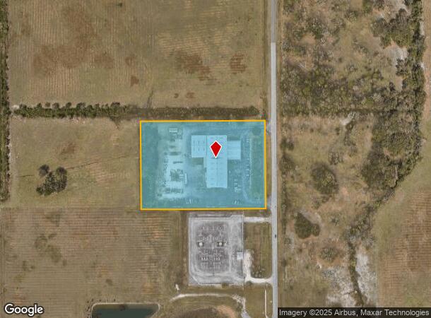
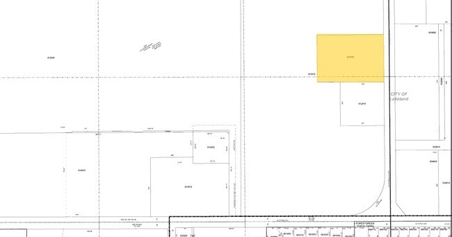
Property Record
2985 Old Medulla Rd, Lakeland, FL 33811
NEARBY LISTINGS FOR SALE OR LEASE
Property Detail
2985 Old Medulla Rd
23-29-09-000000-011070
Forest Brook (Secs 9 10 And 15)
Lightindustrial
COMM NE COR SEC 9 RUN S 936.31 FT RUN W 50 FT TO POB RUN S 430 FT RUN W 607.81 FT RUN N 430 FT RUN E 607.81 FT TO POB
X
Polk
12105C0460G
Florida
2024
6 AC
2025
Polk County
011902
Tampa/St Petersburg
38,350 SF
Lakeland-Winter Haven, FL
DEMOGRAPHICS near 2985 Old Medulla Rd
1 Mile
3 Mile
5 Mile
2024 Total Population
2,313
31,983
113,584
2029 Population
2,742
37,992
134,743
Pop Growth 2024-2029
+ 18.55%
+ 18.79%
+ 18.63%
Average Age
40
40
41
2024 Total Households
827
12,730
44,601
HH Growth 2024-2029
+ 18.38%
+ 18.70%
+ 18.73%
Median Household Inc
$83,181
$70,917
$65,820
Avg Household Size
2.70
2.50
2.50
2024 Avg HH Vehicles
2.00
2.00
2.00
Median Home Value
$293,957
$247,412
$233,601
Median Year Built
1988
1992
1985
Nearby Places
Map Layers
Map Styles
 Street
 Aerial
- Restaurants
- Banks
- Shops
- Fitness
- Groceries
PUBLIC TRANSPORTATION
COMMUTER RAIL
Lakeland (Silver Star - Amtrak)
DRIVE
WALK
Distance
Lakeland (Silver Star - Amtrak)
14 min
7.4 mi
Freight Ports
Port of Tampa Bay
DRIVE
WALK
Distance
Port of Tampa Bay
47 min
34.5 mi
SALE & LEASE HISTORY
LISTING DATE
SALE/LEASE

Sep 24, 2016
For Sale
Nearby Properties
Address
Land Use
TOTAL SIZE
Lot Size
Zoning
Address
Land Use
TOTAL SIZE
Lot Size
Zoning
518,028 SF
195.69 AC
Address
Land Use
TOTAL SIZE
Lot Size
Zoning
595,473 SF
47.29 AC
Address
Land Use
TOTAL SIZE
Lot Size
Zoning
315,901 SF
20.55 AC
Address
Land Use
TOTAL SIZE
Lot Size
Zoning
882,663 SF
133.57 AC
PUD
Address
Land Use
TOTAL SIZE
Lot Size
Zoning
364,518 SF
23.38 AC
Address
Land Use
TOTAL SIZE
Lot Size
Zoning
492,859 SF
135.58 AC
Address
Land Use
TOTAL SIZE
Lot Size
Zoning
296,264 SF
26.74 AC
Address
Land Use
TOTAL SIZE
Lot Size
Zoning
363,147 SF
76.15 AC
Address
Land Use
TOTAL SIZE
Lot Size
Zoning
432,087 SF
626.03 AC
PUD
Address
Land Use
TOTAL SIZE
Lot Size
Zoning
333,560 SF
44.88 AC
IND
Address
Land Use
TOTAL SIZE
Lot Size
Zoning
200,200 SF
17.40 AC
XX
Address
Land Use
TOTAL SIZE
Lot Size
Zoning
77,358 SF
8.34 AC
PUD
Address
Land Use
TOTAL SIZE
Lot Size
Zoning
76,250 SF
5.25 AC
Address
Land Use
TOTAL SIZE
Lot Size
Zoning
215,280 SF
19.73 AC
R2
Address
Land Use
TOTAL SIZE
Lot Size
Zoning
112,538 SF
23.44 AC
Address
Land Use
TOTAL SIZE
Lot Size
Zoning
170,844 SF
200.53 AC
PUD
Address
Land Use
TOTAL SIZE
Lot Size
Zoning
63,740 SF
8.63 AC
Address
Land Use
TOTAL SIZE
Lot Size
Zoning
278,400 SF
22.83 AC
XX
Address
Land Use
TOTAL SIZE
Lot Size
Zoning
101,103 SF
13.87 AC
Address
Land Use
TOTAL SIZE
Lot Size
Zoning
216,358 SF
135.58 AC
Address
Land Use
TOTAL SIZE
Lot Size
Zoning
77,232 SF
0.46 AC
Address
Land Use
TOTAL SIZE
Lot Size
Zoning
70,604 SF
7.79 AC
Address
Land Use
TOTAL SIZE
Lot Size
Zoning
145,672 SF
16 AC
Address
Land Use
TOTAL SIZE
Lot Size
Zoning
63,917 SF
3.85 AC
Address
Land Use
TOTAL SIZE
Lot Size
Zoning
119,901 SF
8.46 AC
Address
Land Use
TOTAL SIZE
Lot Size
Zoning
53,576 SF
0.78 AC
PUD
Address
Land Use
TOTAL SIZE
Lot Size
Zoning
199,906 SF
19.73 AC
R2
Address
Land Use
TOTAL SIZE
Lot Size
Zoning
77,297 SF
11.02 AC
Address
Land Use
TOTAL SIZE
Lot Size
Zoning
121,220 SF
10.36 AC
Address
Land Use
TOTAL SIZE
Lot Size
Zoning
109,200 SF
14.59 AC
The World's #1 Commercial Real Estate Marketplace
Connect with us
© 2025 CoStar Group
The information above has been obtained from sources believed reliable. While we do not doubt its accuracy we have not verified it and make no guarantee, warranty or representation about it. It is your responsibility to independently confirm its accuracy and completeness. Any projections, opinions, assumptions, or estimates used are for example only and do not represent the current or future performance of the property. The value of this transaction to you depends on tax and other factors which should be evaluated by your tax, financial, and legal advisors. You and your advisors should conduct a careful, independent investigation of the property to determine to your satisfaction the suitability of the property for your needs.