Property Record
29789 Highway 34 Sw, Albany, OR 97321
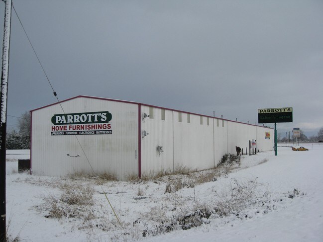


Property Detail
29789 Highway 34 Sw
0390738
11S04W3200
Municipalproperty
Linn
LI
Oregon
C and X Area of minimal flood hazard, usually depicted on FIRMs as above the 500-year flood level.
1.83 AC
2025
Linn County
2025
Portland
030700
Albany, OR
16,812 SF
NEARBY LISTINGS FOR SALE OR LEASE
DEMOGRAPHICS near 29789 Highway 34 Sw
1 mile
3 mile
5 mile
2025 Total Population
299
3,170
64,155
2030 Population
296
3,200
66,823
Pop Growth 2025-2030
(1.00%)
+ 0.95%
+ 4.16%
Average Age
50
47
36
2025 Total Households
141
1,373
25,333
HH Growth 2025-2030
(0.71%)
+ 0.87%
+ 4.54%
Median Household Inc
$85,577
$85,178
$59,103
Avg Household Size
2.10
2.20
2.20
2025 Avg HH Vehicles
2.00
2.00
2.00
Median Home Value
$625,000
$514,000
$465,975
Median Year Built
1968
1972
1978
Nearby Places
Map Layers
Map Styles
 Street
 Aerial
Layers
 Traffic
 Biking
Places
Listings with unknown addresses are not visible on the map
- Restaurants
- Banks
- Shops
- Fitness
- Groceries
PUBLIC TRANSPORTATION
COMMUTER RAIL
Albany Amtrak Station (Amtrak Cascades - Amtrak, Coast Starlight - Amtrak)
Drive
Walk
Distance
Albany Amtrak Station (Amtrak Cascades - Amtrak, Coast Starlight - Amtrak)
13 min
8.0 mi
Freight Ports
Port of Portland
Drive
Walk
Distance
Port of Portland
104 min
83.0 mi
SALE & LEASE HISTORY
LISTING DATE
SALE/LEASE

Sep 24, 2016
For Sale
Nearby Properties
Address
Land Use
TOTAL SIZE
Lot Size
Zoning
Address
Land Use
TOTAL SIZE
Lot Size
Zoning
Address
Land Use
TOTAL SIZE
Lot Size
Zoning
Address
Land Use
TOTAL SIZE
Lot Size
Zoning
169.68 AC
PD(GI)
Address
Land Use
TOTAL SIZE
Lot Size
Zoning
1.20 AC
CBF
Address
Land Use
TOTAL SIZE
Lot Size
Zoning
86,368 SF
2.89 AC
PD(MUE)
Address
Land Use
TOTAL SIZE
Lot Size
Zoning
58,316 SF
8.72 AC
UD-I
Address
Land Use
TOTAL SIZE
Lot Size
Zoning
118,332 SF
0.57 AC
CBF
Address
Land Use
TOTAL SIZE
Lot Size
Zoning
5,680 SF
179.19 AC
EFU
Address
Land Use
TOTAL SIZE
Lot Size
Zoning
13,600 SF
11.89 AC
LI
Address
Land Use
TOTAL SIZE
Lot Size
Zoning
30,976 SF
8.45 AC
PD(GI)
Address
Land Use
TOTAL SIZE
Lot Size
Zoning
105 SF
33.79 AC
EFU
Address
Land Use
TOTAL SIZE
Lot Size
Zoning
Address
Land Use
TOTAL SIZE
Lot Size
Zoning
24,028 SF
0.98 AC
PD(P-AO)
Address
Land Use
TOTAL SIZE
Lot Size
Zoning
10,920 SF
9.12 AC
LI
Address
Land Use
TOTAL SIZE
Lot Size
Zoning
7 AC
HI
Address
Land Use
TOTAL SIZE
Lot Size
Zoning
8.86 AC
PD(GI)
Address
Land Use
TOTAL SIZE
Lot Size
Zoning
10,248 SF
1.55 AC
PD(MUC)
Address
Land Use
TOTAL SIZE
Lot Size
Zoning
1,440 SF
3.32 AC
LI
Address
Land Use
TOTAL SIZE
Lot Size
Zoning
35,235 SF
4.41 AC
LI
Address
Land Use
TOTAL SIZE
Lot Size
Zoning
22,133 SF
9.23 AC
LI
Address
Land Use
TOTAL SIZE
Lot Size
Zoning
5.05 AC
UD-II
Address
Land Use
TOTAL SIZE
Lot Size
Zoning
13,920 SF
2 AC
LI
Address
Land Use
TOTAL SIZE
Lot Size
Zoning
4.28 AC
UD-II
Address
Land Use
TOTAL SIZE
Lot Size
Zoning
24,000 SF
1.99 AC
LI
Address
Land Use
TOTAL SIZE
Lot Size
Zoning
Address
Land Use
TOTAL SIZE
Lot Size
Zoning
218.68 AC
EFU
Address
Land Use
TOTAL SIZE
Lot Size
Zoning
22,884 SF
3.16 AC
LI
Address
Land Use
TOTAL SIZE
Lot Size
Zoning
29,880 SF
5.88 AC
UD-II
Address
Land Use
TOTAL SIZE
Lot Size
Zoning
Address
Land Use
TOTAL SIZE
Lot Size
Zoning
6,016 SF
0.36 AC
CBF
The World's #1 Commercial Real Estate Marketplace
Connect with us
© 2026 CoStar Group
The information above has been obtained from sources believed reliable. While we do not doubt its accuracy we have not verified it and make no guarantee, warranty or representation about it. It is your responsibility to independently confirm its accuracy and completeness. Any projections, opinions, assumptions, or estimates used are for example only and do not represent the current or future performance of the property. The value of this transaction to you depends on tax and other factors which should be evaluated by your tax, financial, and legal advisors. You and your advisors should conduct a careful, independent investigation of the property to determine to your satisfaction the suitability of the property for your needs.