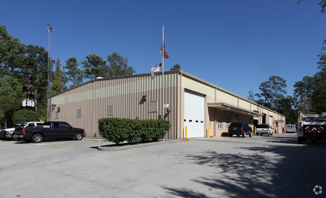
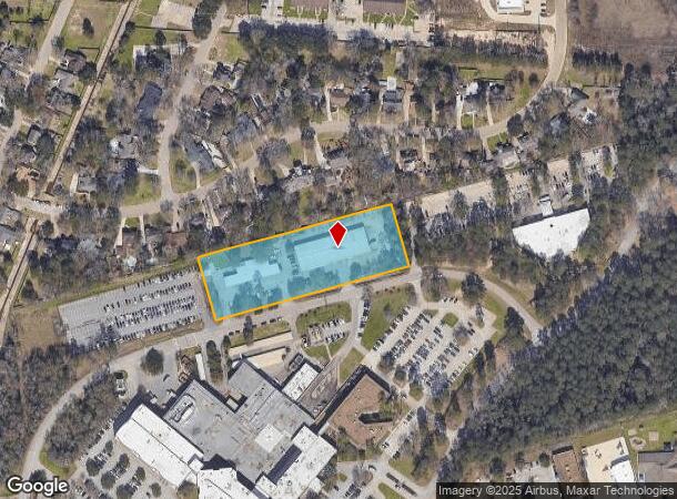
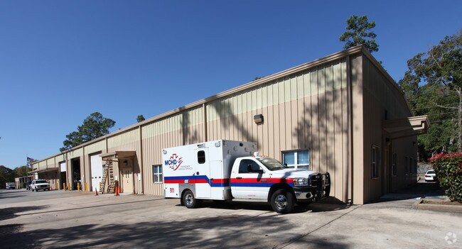
Property Record
299 George Strake Blvd, Conroe, TX 77304
NEARBY LISTINGS FOR SALE OR LEASE
Property Detail
299 George Strake Blvd
5899-00-00100
Hospital District A & B
Commercialnec
S589900 - HOSPITAL DISTRICT A & B, BLOCK 1, RES A, ACRES 2.792
X
Montgomery
48339C0390G
Texas
2024
2.79 AC
2025
The Woodlands/Conroe
693303
Houston
29,688 SF
Houston-Pasadena-The Woodlands, TX
DEMOGRAPHICS near 299 George Strake Blvd
1 Mile
3 Mile
5 Mile
2024 Total Population
8,545
45,575
106,746
2029 Population
10,457
55,835
130,785
Pop Growth 2024-2029
+ 22.38%
+ 22.51%
+ 22.52%
Average Age
35
37
37
2024 Total Households
3,452
16,484
38,721
HH Growth 2024-2029
+ 22.48%
+ 22.65%
+ 23.07%
Median Household Inc
$45,788
$63,544
$73,856
Avg Household Size
2.40
2.70
2.60
2024 Avg HH Vehicles
2.00
2.00
2.00
Median Home Value
$245,103
$240,943
$289,215
Median Year Built
1992
1993
2005
Nearby Places
Map Layers
Map Styles
 Street
 Aerial
- Restaurants
- Banks
- Shops
- Fitness
- Groceries
PUBLIC TRANSPORTATION
AIRPORT
George Bush Intcntl/Houston
DRIVE
WALK
Distance
George Bush Intcntl/Houston
37 min
29.8 mi
Freight Ports
Port of Houston
DRIVE
WALK
Distance
Port of Houston
60 min
45.6 mi
Nearby Properties
Address
Land Use
TOTAL SIZE
Lot Size
Zoning
Address
Land Use
TOTAL SIZE
Lot Size
Zoning
470,259 SF
27.98 AC
1
Address
Land Use
TOTAL SIZE
Lot Size
Zoning
619,770 SF
81.76 AC
Address
Land Use
TOTAL SIZE
Lot Size
Zoning
353,247 SF
14.38 AC
Address
Land Use
TOTAL SIZE
Lot Size
Zoning
292,274 SF
7.55 AC
Address
Land Use
TOTAL SIZE
Lot Size
Zoning
354,000 SF
13.81 AC
Address
Land Use
TOTAL SIZE
Lot Size
Zoning
441,092 SF
29.09 AC
Address
Land Use
TOTAL SIZE
Lot Size
Zoning
304,482 SF
12.15 AC
Address
Land Use
TOTAL SIZE
Lot Size
Zoning
274,494 SF
28.96 AC
Address
Land Use
TOTAL SIZE
Lot Size
Zoning
262,925 SF
12.16 AC
Address
Land Use
TOTAL SIZE
Lot Size
Zoning
284,451 SF
13.66 AC
1
Address
Land Use
TOTAL SIZE
Lot Size
Zoning
326,478 SF
20.22 AC
Address
Land Use
TOTAL SIZE
Lot Size
Zoning
159,144 SF
32.27 AC
Address
Land Use
TOTAL SIZE
Lot Size
Zoning
168,926 SF
9.12 AC
Address
Land Use
TOTAL SIZE
Lot Size
Zoning
195,956 SF
1.76 AC
1
Address
Land Use
TOTAL SIZE
Lot Size
Zoning
276,238 SF
21.48 AC
Address
Land Use
TOTAL SIZE
Lot Size
Zoning
211,275 SF
12.58 AC
Address
Land Use
TOTAL SIZE
Lot Size
Zoning
191,006 SF
9.19 AC
Address
Land Use
TOTAL SIZE
Lot Size
Zoning
142,800 SF
7.82 AC
Address
Land Use
TOTAL SIZE
Lot Size
Zoning
136,300 SF
9.08 AC
1
Address
Land Use
TOTAL SIZE
Lot Size
Zoning
89,298 SF
9.22 AC
Address
Land Use
TOTAL SIZE
Lot Size
Zoning
590,471 SF
32.21 AC
Address
Land Use
TOTAL SIZE
Lot Size
Zoning
197,533 SF
58.31 AC
Address
Land Use
TOTAL SIZE
Lot Size
Zoning
100,800 SF
8.60 AC
Address
Land Use
TOTAL SIZE
Lot Size
Zoning
85,560 SF
8.55 AC
Address
Land Use
TOTAL SIZE
Lot Size
Zoning
175,476 SF
8.03 AC
1
Address
Land Use
TOTAL SIZE
Lot Size
Zoning
70,010 SF
8.89 AC
Address
Land Use
TOTAL SIZE
Lot Size
Zoning
99,660 SF
4.19 AC
Address
Land Use
TOTAL SIZE
Lot Size
Zoning
94,950 SF
7.41 AC
1
Address
Land Use
TOTAL SIZE
Lot Size
Zoning
148,906 SF
7.05 AC
1
The World's #1 Commercial Real Estate Marketplace
Connect with us
© 2026 CoStar Group
The information above has been obtained from sources believed reliable. While we do not doubt its accuracy we have not verified it and make no guarantee, warranty or representation about it. It is your responsibility to independently confirm its accuracy and completeness. Any projections, opinions, assumptions, or estimates used are for example only and do not represent the current or future performance of the property. The value of this transaction to you depends on tax and other factors which should be evaluated by your tax, financial, and legal advisors. You and your advisors should conduct a careful, independent investigation of the property to determine to your satisfaction the suitability of the property for your needs.