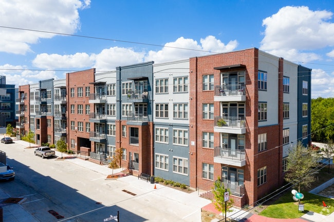
Property Record
299 Monroe Ave, Roanoke, TX 76262
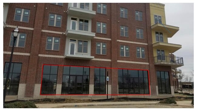

Current Lease Availabilities
Property Detail
299 Monroe Ave
Dallas-Fort Worth-Arlington, TX
ROANOKE CITY CENTER BLK C LOT 1(E PT)
R707611
DENTON
Apartment
Texas
B and X Area of moderate flood hazard, usually the area between the limits of the 100-year and 500-year floods.
1
2024
3.29 AC
2025
North Fort Worth
020311
Dallas/Ft Worth
144,527 SF
NEARBY LISTINGS FOR SALE OR LEASE
DEMOGRAPHICS near 299 Monroe Ave
1 mile
3 mile
5 mile
2025 Total Population
2,259
43,883
117,887
2030 Population
2,582
48,510
127,763
Pop Growth 2025-2030
+ 14.30%
+ 10.54%
+ 8.38%
Average Age
38
38
38
2025 Total Households
1,039
14,781
39,829
HH Growth 2025-2030
+ 14.63%
+ 11.03%
+ 8.72%
Median Household Inc
$95,462
$154,629
$135,628
Avg Household Size
2.10
2.90
2.90
2025 Avg HH Vehicles
2.00
2.00
2.00
Median Home Value
$453,333
$645,723
$539,620
Median Year Built
1995
2008
2006
Nearby Places
Map Layers
Map Styles
 Street
 Aerial
Layers
 Traffic
 Biking
Places
Listings with unknown addresses are not visible on the map
- Restaurants
- Banks
- Shops
- Fitness
- Groceries
PUBLIC TRANSPORTATION
AIRPORT
Dallas-Fort Worth International
Drive
Walk
Distance
Dallas-Fort Worth International
22 min
16.7 mi
Dallas Love Field
Drive
Walk
Distance
Dallas Love Field
41 min
30.4 mi
Freight Ports
Port of Shreveport
Drive
Walk
Distance
Port of Shreveport
250 min
230.3 mi
Nearby Properties
Address
Land Use
TOTAL SIZE
Lot Size
Zoning
Address
Land Use
TOTAL SIZE
Lot Size
Zoning
1,542,470 SF
147.33 AC
Address
Land Use
TOTAL SIZE
Lot Size
Zoning
1,213,448 SF
59.10 AC
Address
Land Use
TOTAL SIZE
Lot Size
Zoning
1,315,600 SF
106.95 AC
Address
Land Use
TOTAL SIZE
Lot Size
Zoning
562,929 SF
15.89 AC
Address
Land Use
TOTAL SIZE
Lot Size
Zoning
413,316 SF
22.96 AC
Address
Land Use
TOTAL SIZE
Lot Size
Zoning
470,000 SF
11.91 AC
Address
Land Use
TOTAL SIZE
Lot Size
Zoning
495,170 SF
14.02 AC
Address
Land Use
TOTAL SIZE
Lot Size
Zoning
455,935 SF
57.27 AC
Address
Land Use
TOTAL SIZE
Lot Size
Zoning
819,327 SF
143.07 AC
Address
Land Use
TOTAL SIZE
Lot Size
Zoning
261,836 SF
33.32 AC
Address
Land Use
TOTAL SIZE
Lot Size
Zoning
261,836 SF
51.66 AC
Address
Land Use
TOTAL SIZE
Lot Size
Zoning
254,250 SF
6.21 AC
Address
Land Use
TOTAL SIZE
Lot Size
Zoning
1,603,686 SF
81.43 AC
Address
Land Use
TOTAL SIZE
Lot Size
Zoning
1,420,661 SF
40.78 AC
Address
Land Use
TOTAL SIZE
Lot Size
Zoning
301,718 SF
18.12 AC
10 G
Address
Land Use
TOTAL SIZE
Lot Size
Zoning
1,010,969 SF
76.73 AC
Address
Land Use
TOTAL SIZE
Lot Size
Zoning
815,370 SF
41.27 AC
Address
Land Use
TOTAL SIZE
Lot Size
Zoning
756,351 SF
33 AC
Address
Land Use
TOTAL SIZE
Lot Size
Zoning
291,475 SF
2.63 AC
Address
Land Use
TOTAL SIZE
Lot Size
Zoning
860,100 SF
40.02 AC
Address
Land Use
TOTAL SIZE
Lot Size
Zoning
756,351 SF
33 AC
Address
Land Use
TOTAL SIZE
Lot Size
Zoning
371,473 SF
82.85 AC
Address
Land Use
TOTAL SIZE
Lot Size
Zoning
667,152 SF
34.50 AC
Address
Land Use
TOTAL SIZE
Lot Size
Zoning
448,068 SF
34.33 AC
Address
Land Use
TOTAL SIZE
Lot Size
Zoning
756,180 SF
39.10 AC
Address
Land Use
TOTAL SIZE
Lot Size
Zoning
569,365 SF
68.61 AC
Address
Land Use
TOTAL SIZE
Lot Size
Zoning
607,962 SF
36.39 AC
Address
Land Use
TOTAL SIZE
Lot Size
Zoning
611,932 SF
30.05 AC
Address
Land Use
TOTAL SIZE
Lot Size
Zoning
490,627 SF
27.53 AC
Address
Land Use
TOTAL SIZE
Lot Size
Zoning
494,930 SF
28.62 AC
The World's #1 Commercial Real Estate Marketplace
Connect with us
© 2026 CoStar Group
The information above has been obtained from sources believed reliable. While we do not doubt its accuracy we have not verified it and make no guarantee, warranty or representation about it. It is your responsibility to independently confirm its accuracy and completeness. Any projections, opinions, assumptions, or estimates used are for example only and do not represent the current or future performance of the property. The value of this transaction to you depends on tax and other factors which should be evaluated by your tax, financial, and legal advisors. You and your advisors should conduct a careful, independent investigation of the property to determine to your satisfaction the suitability of the property for your needs.