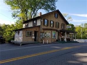
Property Record
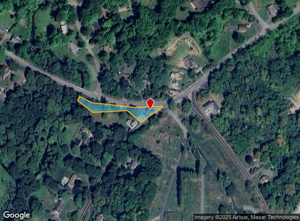
299 Peekskill Hollow Rd, Putnam Valley, NY 10579

NEARBY LISTINGS FOR SALE OR LEASE
Property Detail
299 Peekskill Hollow Rd
372800-084-007-0001-005-000-0000
Putnam
Commercialnec
New York
AE
5.000
36079C0202E
0.52 AC
2024
Carmel
2024
Westchester/So Connecticut
010902
Dutchess County-Putnam County, NY
3,021 SF
DEMOGRAPHICS near 299 Peekskill Hollow Rd
1 Mile
3 Mile
5 Mile
2024 Total Population
1,063
26,848
68,748
2029 Population
1,072
26,548
67,714
Pop Growth 2024-2029
+ 0.85%
(1.12%)
(1.50%)
Average Age
42
44
43
2024 Total Households
360
9,754
24,127
HH Growth 2024-2029
+ 0.83%
(1.33%)
(1.69%)
Median Household Inc
$116,071
$119,550
$128,241
Avg Household Size
2.90
2.70
2.80
2024 Avg HH Vehicles
2.00
2.00
2.00
Median Home Value
$436,082
$421,957
$444,825
Median Year Built
1967
1964
1965
Nearby Places
- Restaurants
- Banks
- Shops
- Fitness
- Groceries
PUBLIC TRANSPORTATION
COMMUTER RAIL
Peekskill Station (Hudson Line - Metro-North Commuter Railroad Company (Metro-North))
DRIVE
WALK
Distance
Peekskill Station (Hudson Line - Metro-North Commuter Railroad Company (Metro-North))
15 min
7.9 mi
AIRPORT
Westchester County
DRIVE
WALK
Distance
Westchester County
42 min
29.0 mi
New York Stewart International
DRIVE
WALK
Distance
New York Stewart International
55 min
31.2 mi
Freight Ports
NY - Red Hook Container Terminal
DRIVE
WALK
Distance
NY - Red Hook Container Terminal
85 min
57.4 mi
SALE & LEASE HISTORY
LISTING DATE
SALE/LEASE

May 08, 2018
For Sale
Jul 19, 2021
For Sale
Aug 02, 2022
For Sale
Nearby Properties
Address
Land Use
TOTAL SIZE
Lot Size
Zoning
Address
Land Use
TOTAL SIZE
Lot Size
Zoning
1,656 SF
80.06 AC
R
Address
Land Use
TOTAL SIZE
Lot Size
Zoning
400 SF
6.29 AC
C
Address
Land Use
TOTAL SIZE
Lot Size
Zoning
78,331 SF
37.78 AC
R2
Address
Land Use
TOTAL SIZE
Lot Size
Zoning
78,529 SF
34.50 AC
R3
Address
Land Use
TOTAL SIZE
Lot Size
Zoning
88,339 SF
90.53 AC
R3
Address
Land Use
TOTAL SIZE
Lot Size
Zoning
Address
Land Use
TOTAL SIZE
Lot Size
Zoning
Address
Land Use
TOTAL SIZE
Lot Size
Zoning
5,380 SF
8.16 AC
CD
Address
Land Use
TOTAL SIZE
Lot Size
Zoning
Address
Land Use
TOTAL SIZE
Lot Size
Zoning
Address
Land Use
TOTAL SIZE
Lot Size
Zoning
18,865 SF
161.60 AC
PD
Address
Land Use
TOTAL SIZE
Lot Size
Zoning
368.63 AC
0
Address
Land Use
TOTAL SIZE
Lot Size
Zoning
Address
Land Use
TOTAL SIZE
Lot Size
Zoning
Address
Land Use
TOTAL SIZE
Lot Size
Zoning
2,784 SF
2.73 AC
CC2
Address
Land Use
TOTAL SIZE
Lot Size
Zoning
878 SF
62.50 AC
R1-20
Address
Land Use
TOTAL SIZE
Lot Size
Zoning
13,520 SF
1.16 AC
CC1
Address
Land Use
TOTAL SIZE
Lot Size
Zoning
21,569 SF
61.43 AC
PD
Address
Land Use
TOTAL SIZE
Lot Size
Zoning
31,714 SF
13.88 AC
R2
Address
Land Use
TOTAL SIZE
Lot Size
Zoning
21,466 SF
2.87 AC
CC1
Address
Land Use
TOTAL SIZE
Lot Size
Zoning
13 AC
R1-40
Address
Land Use
TOTAL SIZE
Lot Size
Zoning
13.55 AC
R3
Address
Land Use
TOTAL SIZE
Lot Size
Zoning
5,278 SF
67.05 AC
R3
Address
Land Use
TOTAL SIZE
Lot Size
Zoning
6,056 SF
11 AC
CD
Address
Land Use
TOTAL SIZE
Lot Size
Zoning
1,632 SF
60.28 AC
PD
Address
Land Use
TOTAL SIZE
Lot Size
Zoning
221 SF
0.78 AC
R
Address
Land Use
TOTAL SIZE
Lot Size
Zoning
14,058 SF
7.26 AC
PD
Address
Land Use
TOTAL SIZE
Lot Size
Zoning
2,405 SF
0.72 AC
R3
Address
Land Use
TOTAL SIZE
Lot Size
Zoning
7,183 SF
5 AC
R1
Address
Land Use
TOTAL SIZE
Lot Size
Zoning
2,092 SF
120.03 AC
R3
The World's #1 Commercial Real Estate Marketplace
Connect with us
© 2025 CoStar Group
The information above has been obtained from sources believed reliable. While we do not doubt its accuracy we have not verified it and make no guarantee, warranty or representation about it. It is your responsibility to independently confirm its accuracy and completeness. Any projections, opinions, assumptions, or estimates used are for example only and do not represent the current or future performance of the property. The value of this transaction to you depends on tax and other factors which should be evaluated by your tax, financial, and legal advisors. You and your advisors should conduct a careful, independent investigation of the property to determine to your satisfaction the suitability of the property for your needs.