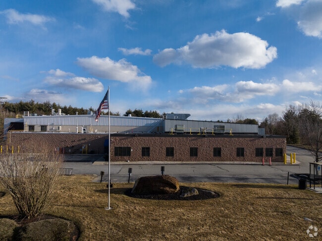
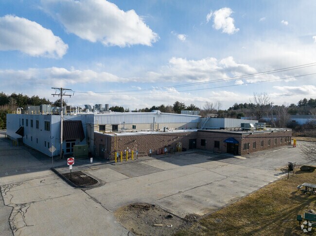
Property Record
299 Pepsi Rd, Manchester, NH 03109


NEARBY LISTINGS FOR SALE OR LEASE
Property Detail
299 Pepsi Rd
MNCH-000717-000000-000011
Hillsborough
Industrialgeneral
New Hampshire
A
11
33011C0382D
18.91 AC
2024
Hillsborough
2024
Boston
001000
Manchester-Nashua, NH
40,416 SF
DEMOGRAPHICS near 299 Pepsi Rd
1 Mile
3 Mile
5 Mile
2024 Total Population
2,815
56,308
126,809
2029 Population
2,874
57,120
129,235
Pop Growth 2024-2029
+ 2.10%
+ 1.44%
+ 1.91%
Average Age
42
40
40
2024 Total Households
1,108
23,025
52,513
HH Growth 2024-2029
+ 2.26%
+ 1.44%
+ 1.91%
Median Household Inc
$102,247
$73,619
$76,065
Avg Household Size
2.40
2.30
2.30
2024 Avg HH Vehicles
2.00
2.00
2.00
Median Home Value
$333,287
$298,234
$329,762
Median Year Built
1980
1965
1968
Nearby Places
Map Layers
Map Styles
 Street
 Aerial
- Restaurants
- Banks
- Shops
- Fitness
- Groceries
PUBLIC TRANSPORTATION
AIRPORT
Manchester Boston Regional
DRIVE
WALK
Distance
Manchester Boston Regional
20 min
8.1 mi
Freight Ports
Port of Boston
DRIVE
WALK
Distance
Port of Boston
83 min
52.3 mi
SALE & LEASE HISTORY
LISTING DATE
SALE/LEASE

Sep 12, 2023
For Sale
Nearby Properties
Address
Land Use
TOTAL SIZE
Lot Size
Zoning
Address
Land Use
TOTAL SIZE
Lot Size
Zoning
446,957 SF
24.16 AC
Address
Land Use
TOTAL SIZE
Lot Size
Zoning
383,493 SF
34.51 AC
Address
Land Use
TOTAL SIZE
Lot Size
Zoning
6,830 SF
17.24 AC
Address
Land Use
TOTAL SIZE
Lot Size
Zoning
8,064 SF
34.29 AC
Address
Land Use
TOTAL SIZE
Lot Size
Zoning
217,697 SF
43.25 AC
Address
Land Use
TOTAL SIZE
Lot Size
Zoning
22,101 SF
8.33 AC
Address
Land Use
TOTAL SIZE
Lot Size
Zoning
723,875 SF
38.08 AC
Address
Land Use
TOTAL SIZE
Lot Size
Zoning
49,788 SF
34.73 AC
Address
Land Use
TOTAL SIZE
Lot Size
Zoning
24,064 SF
19.44 AC
Address
Land Use
TOTAL SIZE
Lot Size
Zoning
201,831 SF
18.46 AC
IND-II
Address
Land Use
TOTAL SIZE
Lot Size
Zoning
211,525 SF
93.01 AC
Address
Land Use
TOTAL SIZE
Lot Size
Zoning
180,474 SF
18.60 AC
Address
Land Use
TOTAL SIZE
Lot Size
Zoning
2,218 SF
17.11 AC
Address
Land Use
TOTAL SIZE
Lot Size
Zoning
Address
Land Use
TOTAL SIZE
Lot Size
Zoning
38,506 SF
9.88 AC
Address
Land Use
TOTAL SIZE
Lot Size
Zoning
171,811 SF
44.42 AC
Address
Land Use
TOTAL SIZE
Lot Size
Zoning
6,110 SF
12.99 AC
Address
Land Use
TOTAL SIZE
Lot Size
Zoning
114,380 SF
7.64 AC
Address
Land Use
TOTAL SIZE
Lot Size
Zoning
162,272 SF
9.69 AC
Address
Land Use
TOTAL SIZE
Lot Size
Zoning
123,966 SF
13 AC
Address
Land Use
TOTAL SIZE
Lot Size
Zoning
92,492 SF
85 AC
Address
Land Use
TOTAL SIZE
Lot Size
Zoning
112,851 SF
10.93 AC
Address
Land Use
TOTAL SIZE
Lot Size
Zoning
134,586 SF
14.84 AC
Address
Land Use
TOTAL SIZE
Lot Size
Zoning
131,003 SF
49.31 AC
Address
Land Use
TOTAL SIZE
Lot Size
Zoning
28,888 SF
5.50 AC
Address
Land Use
TOTAL SIZE
Lot Size
Zoning
16,000 SF
20.69 AC
Address
Land Use
TOTAL SIZE
Lot Size
Zoning
105,525 SF
11.76 AC
Address
Land Use
TOTAL SIZE
Lot Size
Zoning
3,803 SF
13.83 AC
Address
Land Use
TOTAL SIZE
Lot Size
Zoning
106,338 SF
18 AC
Address
Land Use
TOTAL SIZE
Lot Size
Zoning
72,590 SF
17.28 AC
The World's #1 Commercial Real Estate Marketplace
Connect with us
© 2026 CoStar Group
The information above has been obtained from sources believed reliable. While we do not doubt its accuracy we have not verified it and make no guarantee, warranty or representation about it. It is your responsibility to independently confirm its accuracy and completeness. Any projections, opinions, assumptions, or estimates used are for example only and do not represent the current or future performance of the property. The value of this transaction to you depends on tax and other factors which should be evaluated by your tax, financial, and legal advisors. You and your advisors should conduct a careful, independent investigation of the property to determine to your satisfaction the suitability of the property for your needs.