Property Record
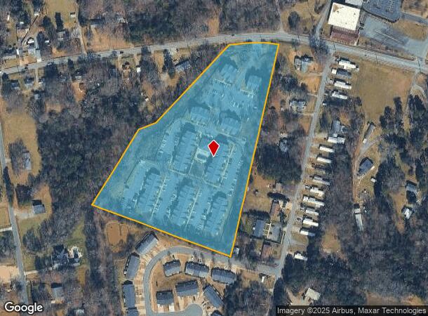
2993 Poplar Tent Rd, Concord, NC 28027
NEARBY LISTINGS FOR SALE OR LEASE
Property Detail
2993 Poplar Tent Rd
5610-48-8421-0000
Montford Ave Area
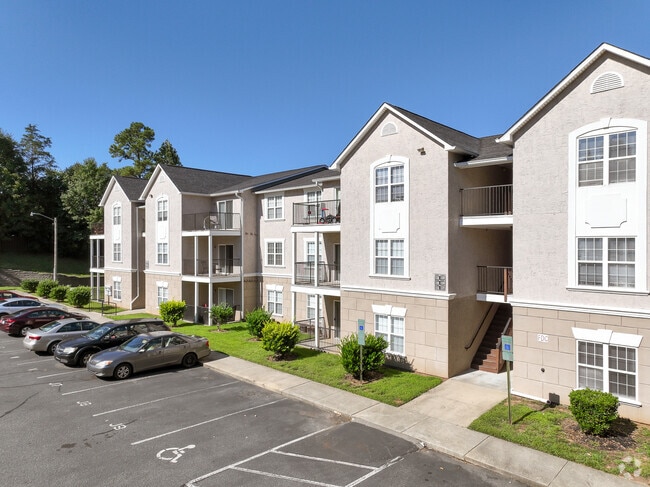
Gardenaptcourtapt5plusunits
SOUTH SIDE POPLAR TENT RD
AE
Cabarrus
3710561000K
North Carolina
2025
10.22 AC
2025
Outlying Cabarrus County
042503
Charlotte
12,480 SF
Charlotte-Concord-Gastonia, NC-SC
DEMOGRAPHICS near 2993 Poplar Tent Rd
1 Mile
3 Mile
5 Mile
2024 Total Population
5,439
51,881
114,544
2029 Population
6,164
58,814
129,547
Pop Growth 2024-2029
+ 13.33%
+ 13.36%
+ 13.10%
Average Age
40
39
39
2024 Total Households
2,063
20,124
43,541
HH Growth 2024-2029
+ 11.92%
+ 11.90%
+ 11.70%
Median Household Inc
$84,838
$64,232
$73,019
Avg Household Size
2.50
2.50
2.50
2024 Avg HH Vehicles
2.00
2.00
2.00
Median Home Value
$265,271
$259,309
$256,305
Median Year Built
1993
1990
1993
Nearby Places
Map Layers
Map Styles
 Street
 Aerial
- Restaurants
- Banks
- Shops
- Fitness
- Groceries
PUBLIC TRANSPORTATION
COMMUTER RAIL
Kannapolis Station (Piedmont - North Carolina by Train (NC Train))
DRIVE
WALK
Distance
Kannapolis Station (Piedmont - North Carolina by Train (NC Train))
15 min
8.2 mi
AIRPORT
Concord-Padgett Regional
DRIVE
WALK
Distance
Concord-Padgett Regional
16 min
7.8 mi
Charlotte/Douglas International
DRIVE
WALK
Distance
Charlotte/Douglas International
42 min
28.6 mi
Freight Ports
Port of Wilmington
DRIVE
WALK
Distance
Port of Wilmington
255 min
198.1 mi
Nearby Properties
Address
Land Use
TOTAL SIZE
Lot Size
Zoning
Address
Land Use
TOTAL SIZE
Lot Size
Zoning
122,131 SF
415.58 AC
I-2
Address
Land Use
TOTAL SIZE
Lot Size
Zoning
280,149 SF
54.88 AC
C-2
Address
Land Use
TOTAL SIZE
Lot Size
Zoning
162,854 SF
2.11 AC
CC
Address
Land Use
TOTAL SIZE
Lot Size
Zoning
103,849 SF
3.03 AC
CC
Address
Land Use
TOTAL SIZE
Lot Size
Zoning
23,940 SF
45.03 AC
C-1
Address
Land Use
TOTAL SIZE
Lot Size
Zoning
333,623 SF
108.12 AC
RV
Address
Land Use
TOTAL SIZE
Lot Size
Zoning
495.38 AC
I-2
Address
Land Use
TOTAL SIZE
Lot Size
Zoning
670.09 AC
I-2
Address
Land Use
TOTAL SIZE
Lot Size
Zoning
16,216 SF
24.13 AC
RC
Address
Land Use
TOTAL SIZE
Lot Size
Zoning
14,691 SF
18.37 AC
R18
Address
Land Use
TOTAL SIZE
Lot Size
Zoning
30,360 SF
17.59 AC
CD-R
Address
Land Use
TOTAL SIZE
Lot Size
Zoning
360,050 SF
56.57 AC
I-2
Address
Land Use
TOTAL SIZE
Lot Size
Zoning
30,423 SF
20.75 AC
RC
Address
Land Use
TOTAL SIZE
Lot Size
Zoning
163,494 SF
89.85 AC
I-2
Address
Land Use
TOTAL SIZE
Lot Size
Zoning
136,582 SF
24.87 AC
I-2
Address
Land Use
TOTAL SIZE
Lot Size
Zoning
30,108 SF
42.53 AC
CD
Address
Land Use
TOTAL SIZE
Lot Size
Zoning
32,872 SF
0.90 AC
CC
Address
Land Use
TOTAL SIZE
Lot Size
Zoning
6,880 SF
18.34 AC
RC
Address
Land Use
TOTAL SIZE
Lot Size
Zoning
203,931 SF
44.99 AC
RM-2
Address
Land Use
TOTAL SIZE
Lot Size
Zoning
310,387 SF
20.66 AC
I-2
Address
Land Use
TOTAL SIZE
Lot Size
Zoning
122,102 SF
4.69 AC
CC
Address
Land Use
TOTAL SIZE
Lot Size
Zoning
55,158 SF
63.68 AC
O-I
Address
Land Use
TOTAL SIZE
Lot Size
Zoning
38,595 SF
11.71 AC
RC
Address
Land Use
TOTAL SIZE
Lot Size
Zoning
331,452 SF
59.37 AC
I-1
Address
Land Use
TOTAL SIZE
Lot Size
Zoning
173,459 SF
15.03 AC
O-I
Address
Land Use
TOTAL SIZE
Lot Size
Zoning
161,202 SF
2.68 AC
CC
Address
Land Use
TOTAL SIZE
Lot Size
Zoning
15,156 SF
12.54 AC
RC
Address
Land Use
TOTAL SIZE
Lot Size
Zoning
90,350 SF
10.20 AC
PID
Address
Land Use
TOTAL SIZE
Lot Size
Zoning
297,232 SF
31.82 AC
I-2
The World's #1 Commercial Real Estate Marketplace
Connect with us
© 2026 CoStar Group
The information above has been obtained from sources believed reliable. While we do not doubt its accuracy we have not verified it and make no guarantee, warranty or representation about it. It is your responsibility to independently confirm its accuracy and completeness. Any projections, opinions, assumptions, or estimates used are for example only and do not represent the current or future performance of the property. The value of this transaction to you depends on tax and other factors which should be evaluated by your tax, financial, and legal advisors. You and your advisors should conduct a careful, independent investigation of the property to determine to your satisfaction the suitability of the property for your needs.