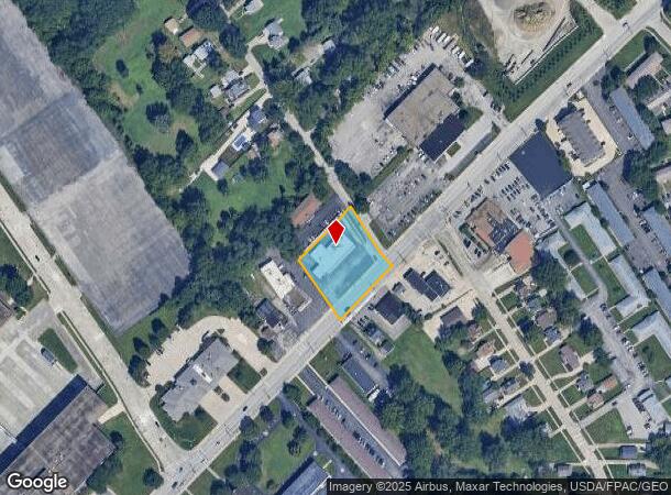
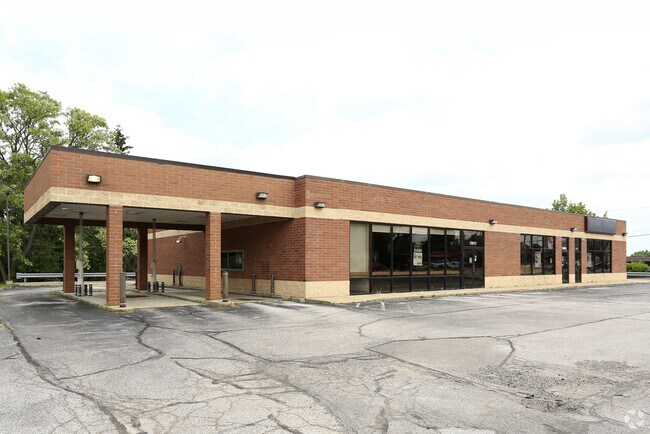
Property Record
29933 Euclid Ave, Wickliffe, OH 44092

NEARBY LISTINGS FOR SALE OR LEASE
Property Detail
29933 Euclid Ave
Cleveland-Elyria, OH
Jas. A. Frys Oak Meadow Subd No 3
29-A-003-A-00-030
LLOYD LOT TRACT 12 & LOT 11 TRACT 11 PART OF S/L 23 & 24
Storebuilding
Lake
X
Ohio
39035C0102E
23-24
0
0.62 AC
2024
Northeast
200600
Cleveland
5,578 SF
DEMOGRAPHICS near 29933 Euclid Ave
1 Mile
3 Mile
5 Mile
2024 Total Population
10,358
77,703
134,893
2029 Population
10,295
77,471
133,858
Pop Growth 2024-2029
(0.61%)
(0.30%)
(0.77%)
Average Age
43
43
43
2024 Total Households
4,711
36,931
61,899
HH Growth 2024-2029
(0.64%)
(0.30%)
(0.73%)
Median Household Inc
$73,304
$54,762
$57,371
Avg Household Size
2.20
2.10
2.10
2024 Avg HH Vehicles
2.00
2.00
2.00
Median Home Value
$144,826
$145,434
$155,205
Median Year Built
1957
1961
1960
Nearby Places
Map Layers
Map Styles
 Street
 Aerial
- Restaurants
- Banks
- Shops
- Fitness
- Groceries
PUBLIC TRANSPORTATION
AIRPORT
Cleveland-Hopkins International
DRIVE
WALK
Distance
Cleveland-Hopkins International
34 min
28.8 mi
Freight Ports
Port of Baltimore
DRIVE
WALK
Distance
Port of Baltimore
1 min
303.0 mi
SALE & LEASE HISTORY
LISTING DATE
SALE/LEASE

Dec 14, 2023
For Lease
Dec 08, 2023
For Sale
Nearby Properties
Address
Land Use
TOTAL SIZE
Lot Size
Zoning
Address
Land Use
TOTAL SIZE
Lot Size
Zoning
71.14 AC
U4
Address
Land Use
TOTAL SIZE
Lot Size
Zoning
488,790 SF
11.54 AC
R-MFL
Address
Land Use
TOTAL SIZE
Lot Size
Zoning
1,283,872 SF
11.33 AC
U3
Address
Land Use
TOTAL SIZE
Lot Size
Zoning
827,164 SF
8 AC
U3
Address
Land Use
TOTAL SIZE
Lot Size
Zoning
190,580 SF
7.90 AC
P.F.
Address
Land Use
TOTAL SIZE
Lot Size
Zoning
336,126 SF
72.98 AC
1-R
Address
Land Use
TOTAL SIZE
Lot Size
Zoning
307,867 SF
31.16 AC
S-CMF
Address
Land Use
TOTAL SIZE
Lot Size
Zoning
308,298 SF
15.93 AC
Address
Land Use
TOTAL SIZE
Lot Size
Zoning
300,691 SF
36.39 AC
1R
Address
Land Use
TOTAL SIZE
Lot Size
Zoning
120,352 SF
15.05 AC
1FM60
Address
Land Use
TOTAL SIZE
Lot Size
Zoning
226,141 SF
6.50 AC
M
Address
Land Use
TOTAL SIZE
Lot Size
Zoning
102,182 SF
4.25 AC
M
Address
Land Use
TOTAL SIZE
Lot Size
Zoning
175,620 SF
8.65 AC
M
Address
Land Use
TOTAL SIZE
Lot Size
Zoning
208,610 SF
7.54 AC
M
Address
Land Use
TOTAL SIZE
Lot Size
Zoning
241,441 SF
17.18 AC
I
Address
Land Use
TOTAL SIZE
Lot Size
Zoning
70,574 SF
6.35 AC
CI
Address
Land Use
TOTAL SIZE
Lot Size
Zoning
416,506 SF
28.90 AC
Address
Land Use
TOTAL SIZE
Lot Size
Zoning
75,843 SF
10.23 AC
B
Address
Land Use
TOTAL SIZE
Lot Size
Zoning
64,113 SF
5.74 AC
M
Address
Land Use
TOTAL SIZE
Lot Size
Zoning
70,643 SF
8.26 AC
CI
Address
Land Use
TOTAL SIZE
Lot Size
Zoning
358,547 SF
8.22 AC
U3EL
Address
Land Use
TOTAL SIZE
Lot Size
Zoning
447,868 SF
6.22 AC
U3
Address
Land Use
TOTAL SIZE
Lot Size
Zoning
272,400 SF
1.07 AC
U2D
Address
Land Use
TOTAL SIZE
Lot Size
Zoning
53,637 SF
13.45 AC
G-BUS
Address
Land Use
TOTAL SIZE
Lot Size
Zoning
65,102 SF
8.80 AC
M
Address
Land Use
TOTAL SIZE
Lot Size
Zoning
109,614 SF
8.48 AC
I
Address
Land Use
TOTAL SIZE
Lot Size
Zoning
54,671 SF
3.72 AC
R
Address
Land Use
TOTAL SIZE
Lot Size
Zoning
137,753 SF
4.40 AC
U6
Address
Land Use
TOTAL SIZE
Lot Size
Zoning
136,722 SF
10.25 AC
GB
Address
Land Use
TOTAL SIZE
Lot Size
Zoning
187,332 SF
10 AC
R-100
The World's #1 Commercial Real Estate Marketplace
Connect with us
© 2025 CoStar Group
The information above has been obtained from sources believed reliable. While we do not doubt its accuracy we have not verified it and make no guarantee, warranty or representation about it. It is your responsibility to independently confirm its accuracy and completeness. Any projections, opinions, assumptions, or estimates used are for example only and do not represent the current or future performance of the property. The value of this transaction to you depends on tax and other factors which should be evaluated by your tax, financial, and legal advisors. You and your advisors should conduct a careful, independent investigation of the property to determine to your satisfaction the suitability of the property for your needs.