Property Record
2995 Bayshore Rd, Benicia, CA 94510

Save to a Folder
{{folder.Name}}
{{folder.ListingIds.length}} Properties
{{folder.ListingIds.length}} Property
Create a New Folder
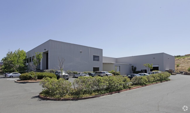
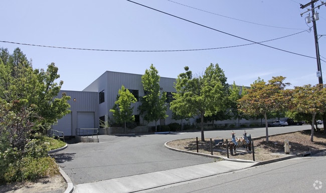
Property Detail
2995 Bayshore Rd
Vallejo, CA
BK-BG 34-95 LOT 1
0080-340-030
Solano
Warehouse
California
INDUSTRIAL
1
B and X Area of moderate flood hazard, usually the area between the limits of the 100-year and 500-year floods.
3.07 AC
2024
Benicia
2025
North Bay/Santa Rosa
252102
NEARBY LISTINGS FOR SALE OR LEASE
DEMOGRAPHICS near 2995 Bayshore Rd
1 mile
3 mile
5 mile
2025 Total Population
1,662
23,902
72,426
2030 Population
1,662
24,021
72,911
Pop Growth 2025-2030
0.00%
+ 0.50%
+ 0.67%
Average Age
43
44
43
2025 Total Households
661
9,737
28,506
HH Growth 2025-2030
0.00%
+ 0.53%
+ 0.74%
Median Household Inc
$115,489
$128,987
$123,743
Avg Household Size
2.50
2.40
2.50
2025 Avg HH Vehicles
2.00
2.00
2.00
Median Home Value
$731,976
$774,445
$752,163
Median Year Built
1969
1978
1979
Nearby Places
Map Layers
Map Styles
 Street
 Aerial
Layers
 Traffic
 Biking
Places
Listings with unknown addresses are not visible on the map
- Restaurants
- Banks
- Shops
- Fitness
- Groceries
PUBLIC TRANSPORTATION
COMMUTER RAIL
Martinez (California Zephyr - Amtrak, Capitol Corridor - Amtrak, Coast Starlight - Amtrak)
Drive
Walk
Distance
Martinez (California Zephyr - Amtrak, Capitol Corridor - Amtrak, Coast Starlight - Amtrak)
8 min
5.2 mi
AIRPORT
Metro Oakland International
Drive
Walk
Distance
Metro Oakland International
48 min
36.6 mi
Freight Ports
Port of Richmond
Drive
Walk
Distance
Port of Richmond
39 min
27.4 mi
SALE & LEASE HISTORY
LISTING DATE
SALE/LEASE

Nov 30, 2021
For Sale
Feb 18, 2018
For Lease
Nearby Properties
Address
Land Use
TOTAL SIZE
Lot Size
Zoning
Address
Land Use
TOTAL SIZE
Lot Size
Zoning
324.69 AC
Address
Land Use
TOTAL SIZE
Lot Size
Zoning
9,000 SF
137.45 AC
Address
Land Use
TOTAL SIZE
Lot Size
Zoning
187,998 SF
135.96 AC
Address
Land Use
TOTAL SIZE
Lot Size
Zoning
15.34 AC
Address
Land Use
TOTAL SIZE
Lot Size
Zoning
68.97 AC
Address
Land Use
TOTAL SIZE
Lot Size
Zoning
49,519 SF
2.04 AC
Address
Land Use
TOTAL SIZE
Lot Size
Zoning
71,000 SF
1.23 AC
Address
Land Use
TOTAL SIZE
Lot Size
Zoning
66.32 AC
Address
Land Use
TOTAL SIZE
Lot Size
Zoning
19.90 AC
Address
Land Use
TOTAL SIZE
Lot Size
Zoning
160,000 SF
13.67 AC
Address
Land Use
TOTAL SIZE
Lot Size
Zoning
200,888 SF
19.11 AC
MR25
Address
Land Use
TOTAL SIZE
Lot Size
Zoning
55,805 SF
9.89 AC
Address
Land Use
TOTAL SIZE
Lot Size
Zoning
22,176 SF
15.14 AC
Address
Land Use
TOTAL SIZE
Lot Size
Zoning
220,527 SF
11.16 AC
INDUSTRIAL
Address
Land Use
TOTAL SIZE
Lot Size
Zoning
243,000 SF
12.62 AC
Address
Land Use
TOTAL SIZE
Lot Size
Zoning
86,222 SF
39.83 AC
Address
Land Use
TOTAL SIZE
Lot Size
Zoning
12.63 AC
Address
Land Use
TOTAL SIZE
Lot Size
Zoning
19.08 AC
Address
Land Use
TOTAL SIZE
Lot Size
Zoning
13.63 AC
Address
Land Use
TOTAL SIZE
Lot Size
Zoning
488,220 SF
11.88 AC
Address
Land Use
TOTAL SIZE
Lot Size
Zoning
240,000 SF
11.77 AC
Address
Land Use
TOTAL SIZE
Lot Size
Zoning
240,000 SF
9.60 AC
INDUSTRIAL
Address
Land Use
TOTAL SIZE
Lot Size
Zoning
12.80 AC
Address
Land Use
TOTAL SIZE
Lot Size
Zoning
14,800 SF
74.08 AC
Address
Land Use
TOTAL SIZE
Lot Size
Zoning
5,259 SF
95.68 AC
Address
Land Use
TOTAL SIZE
Lot Size
Zoning
158,987 SF
8.93 AC
Address
Land Use
TOTAL SIZE
Lot Size
Zoning
115,292 SF
9.85 AC
Address
Land Use
TOTAL SIZE
Lot Size
Zoning
100,547 SF
7.51 AC
Address
Land Use
TOTAL SIZE
Lot Size
Zoning
120,000 SF
5.52 AC
Address
Land Use
TOTAL SIZE
Lot Size
Zoning
1,536,263 SF
7.58 AC
The World's #1 Commercial Real Estate Marketplace
Connect with us
© 2026 CoStar Group
The information above has been obtained from sources believed reliable. While we do not doubt its accuracy we have not verified it and make no guarantee, warranty or representation about it. It is your responsibility to independently confirm its accuracy and completeness. Any projections, opinions, assumptions, or estimates used are for example only and do not represent the current or future performance of the property. The value of this transaction to you depends on tax and other factors which should be evaluated by your tax, financial, and legal advisors. You and your advisors should conduct a careful, independent investigation of the property to determine to your satisfaction the suitability of the property for your needs.