Property Record
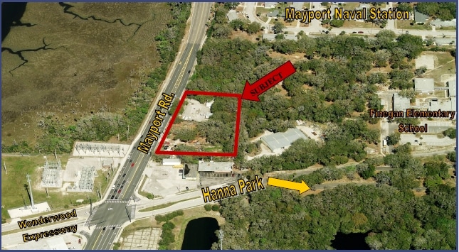
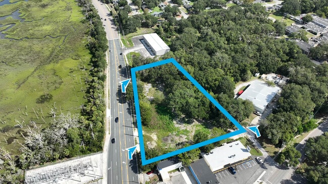
2989 Mayport Rd, Jacksonville, FL 32233

Property Detail
2989 Mayport Rd
168937-0000
1-27 38-1S-29E 2.15 BURNSIDE BEACH LOT D, N 1/2 OF CLD R/W LYING SLY THEREOF RECD O/R 1615-81, W1/2 OLD MAYPORT RD LYING ELY THEREOF CLOSED PER O/R 12431-1798
Commercialacreage
DUVAL
CCG-2
Florida
AE The base floodplain where base flood elevations are provided. AE Zones are now used on new format FIRMs instead of A1-A30 Zones.
d,n
2025
2.13 AC
2026
Beaches
013901
Jacksonville (Florida)
1,200 SF
Jacksonville, FL
NEARBY LISTINGS FOR SALE OR LEASE
DEMOGRAPHICS near 2989 Mayport Rd
1 mile
3 mile
5 mile
2025 Total Population
7,864
29,130
68,348
2030 Population
8,475
31,025
72,142
Pop Growth 2025-2030
+ 7.77%
+ 6.51%
+ 5.55%
Average Age
34
40
41
2025 Total Households
2,095
10,994
27,379
HH Growth 2025-2030
+ 8.97%
+ 6.87%
+ 5.87%
Median Household Inc
$74,478
$86,037
$99,353
Avg Household Size
2.60
2.40
2.40
2025 Avg HH Vehicles
2.00
2.00
2.00
Median Home Value
$407,692
$486,388
$462,860
Median Year Built
1993
1986
1989
Nearby Places
Map Layers
Map Styles
 Street
 Aerial
Layers
 Traffic
 Biking
Places
Listings with unknown addresses are not visible on the map
- Restaurants
- Banks
- Shops
- Fitness
- Groceries
PUBLIC TRANSPORTATION
AIRPORT
Jacksonville International
Drive
Walk
Distance
Jacksonville International
37 min
24.0 mi
Freight Ports
Jacksonville Port
Drive
Walk
Distance
Jacksonville Port
31 min
18.4 mi
SALE & LEASE HISTORY
LISTING DATE
SALE/LEASE

Sep 19, 2023
For Sale
Oct 31, 2016
For Sale
Nov 10, 2023
For Lease
Nearby Properties
Address
Land Use
TOTAL SIZE
Lot Size
Zoning
Address
Land Use
TOTAL SIZE
Lot Size
Zoning
1 SF
1,309.30 AC
PBF-1
Address
Land Use
TOTAL SIZE
Lot Size
Zoning
240,363 SF
24.71 AC
PUD
Address
Land Use
TOTAL SIZE
Lot Size
Zoning
675,298 SF
70.05 AC
APUD
Address
Land Use
TOTAL SIZE
Lot Size
Zoning
34,612 SF
446.76 AC
PBF-1
Address
Land Use
TOTAL SIZE
Lot Size
Zoning
265,386 SF
29.35 AC
RMD-C
Address
Land Use
TOTAL SIZE
Lot Size
Zoning
206,990 SF
15.79 AC
RMD-D
Address
Land Use
TOTAL SIZE
Lot Size
Zoning
185,402 SF
14.03 AC
RMD-C
Address
Land Use
TOTAL SIZE
Lot Size
Zoning
171,440 SF
11.14 AC
PUD
Address
Land Use
TOTAL SIZE
Lot Size
Zoning
157,942 SF
15.55 AC
PUD
Address
Land Use
TOTAL SIZE
Lot Size
Zoning
167,476 SF
12.89 AC
RMD-C
Address
Land Use
TOTAL SIZE
Lot Size
Zoning
248,601 SF
43.01 AC
PBF-1
Address
Land Use
TOTAL SIZE
Lot Size
Zoning
151,117 SF
10.04 AC
RMD-C
Address
Land Use
TOTAL SIZE
Lot Size
Zoning
95,879 SF
14.46 AC
PUD
Address
Land Use
TOTAL SIZE
Lot Size
Zoning
110,902 SF
8.15 AC
RMD-C
Address
Land Use
TOTAL SIZE
Lot Size
Zoning
55,659 SF
6.91 AC
PUD
Address
Land Use
TOTAL SIZE
Lot Size
Zoning
123,803 SF
11.87 AC
PUD
Address
Land Use
TOTAL SIZE
Lot Size
Zoning
98,393 SF
6.50 AC
RMD-C
Address
Land Use
TOTAL SIZE
Lot Size
Zoning
289.86 AC
CSV
Address
Land Use
TOTAL SIZE
Lot Size
Zoning
123,999 SF
76.43 AC
PBF-2
Address
Land Use
TOTAL SIZE
Lot Size
Zoning
254.38 AC
PBF-1
Address
Land Use
TOTAL SIZE
Lot Size
Zoning
120,907 SF
7.94 AC
ARG-M
Address
Land Use
TOTAL SIZE
Lot Size
Zoning
36,926 SF
2.03 AC
CCG-1
Address
Land Use
TOTAL SIZE
Lot Size
Zoning
34,822 SF
7.22 AC
ACL
Address
Land Use
TOTAL SIZE
Lot Size
Zoning
35,857 SF
12.66 AC
ARS-2
Address
Land Use
TOTAL SIZE
Lot Size
Zoning
64,960 SF
5.96 AC
CCG-1
Address
Land Use
TOTAL SIZE
Lot Size
Zoning
26,448 SF
1.47 AC
PUD
Address
Land Use
TOTAL SIZE
Lot Size
Zoning
59,183 SF
6.86 AC
RMD-C
Address
Land Use
TOTAL SIZE
Lot Size
Zoning
69,810 SF
5.41 AC
ACG
Address
Land Use
TOTAL SIZE
Lot Size
Zoning
76,930 SF
5.40 AC
PUD
Address
Land Use
TOTAL SIZE
Lot Size
Zoning
34,888 SF
2.46 AC
ACG
The World's #1 Commercial Real Estate Marketplace
Connect with us
© 2026 CoStar Group
The information above has been obtained from sources believed reliable. While we do not doubt its accuracy we have not verified it and make no guarantee, warranty or representation about it. It is your responsibility to independently confirm its accuracy and completeness. Any projections, opinions, assumptions, or estimates used are for example only and do not represent the current or future performance of the property. The value of this transaction to you depends on tax and other factors which should be evaluated by your tax, financial, and legal advisors. You and your advisors should conduct a careful, independent investigation of the property to determine to your satisfaction the suitability of the property for your needs.