Property Record
29995 Harper Rd, Solon, OH 44139
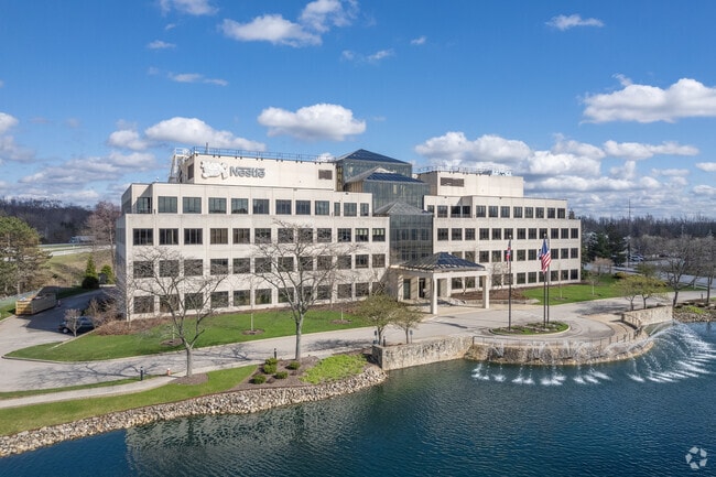

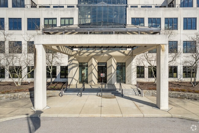
Property Detail
29995 Harper Rd
951-27-004
VOL 377 PG 22 PCL A FF 386.74 D 1174.94 10.2331 AC 19 OL ADDITIONAL PARCELS 95133002, 95133036 & 95133012 THRU 020 2015 SR
Officebuilding
CUYAHOGA
O-1
Ohio
AE The base floodplain where base flood elevations are provided. AE Zones are now used on new format FIRMs instead of A1-A30 Zones.
10.23 AC
2025
Southeast
2025
Cleveland
184106
Cleveland-Elyria, OH
137,352 SF
NEARBY LISTINGS FOR SALE OR LEASE
DEMOGRAPHICS near 29995 Harper Rd
1 mile
3 mile
5 mile
2025 Total Population
2,178
34,722
107,984
2030 Population
2,155
34,469
107,594
Pop Growth 2025-2030
(1.06%)
(0.73%)
(0.36%)
Average Age
44
43
43
2025 Total Households
778
14,371
45,010
HH Growth 2025-2030
(1.03%)
(0.79%)
(0.46%)
Median Household Inc
$148,584
$76,265
$76,463
Avg Household Size
2.80
2.40
2.30
2025 Avg HH Vehicles
2.00
2.00
2.00
Median Home Value
$385,795
$302,651
$290,049
Median Year Built
1976
1970
1966
Nearby Places
Map Layers
Map Styles
 Street
 Aerial
Layers
 Traffic
 Biking
Places
Listings with unknown addresses are not visible on the map
- Restaurants
- Banks
- Shops
- Fitness
- Groceries
PUBLIC TRANSPORTATION
COMMUTER RAIL
Drive
Walk
Distance
21 min
10.0 mi
AIRPORT
Cleveland-Hopkins International
Drive
Walk
Distance
Cleveland-Hopkins International
34 min
22.8 mi
Akron-Canton Regional
Drive
Walk
Distance
Akron-Canton Regional
54 min
40.2 mi
Nearby Properties
Address
Land Use
TOTAL SIZE
Lot Size
Zoning
Address
Land Use
TOTAL SIZE
Lot Size
Zoning
130,621 SF
67.21 AC
I-2
Address
Land Use
TOTAL SIZE
Lot Size
Zoning
202,010 SF
90.68 AC
I-2
Address
Land Use
TOTAL SIZE
Lot Size
Zoning
197,000 SF
42.41 AC
I-2
Address
Land Use
TOTAL SIZE
Lot Size
Zoning
246,138 SF
67.82 AC
R-1-C
Address
Land Use
TOTAL SIZE
Lot Size
Zoning
344,806 SF
35.19 AC
R-1-A
Address
Land Use
TOTAL SIZE
Lot Size
Zoning
184,512 SF
5.22 AC
C-1
Address
Land Use
TOTAL SIZE
Lot Size
Zoning
99,919 SF
17.91 AC
U-1A1
Address
Land Use
TOTAL SIZE
Lot Size
Zoning
458,000 SF
35.06 AC
IG
Address
Land Use
TOTAL SIZE
Lot Size
Zoning
243,040 SF
9.36 AC
R-3-B
Address
Land Use
TOTAL SIZE
Lot Size
Zoning
96,632 SF
13.87 AC
R-3
Address
Land Use
TOTAL SIZE
Lot Size
Zoning
30,386 SF
4.63 AC
R-3
Address
Land Use
TOTAL SIZE
Lot Size
Zoning
838,521 SF
5.70 AC
I
Address
Land Use
TOTAL SIZE
Lot Size
Zoning
49,264 SF
13.36 AC
C-3
Address
Land Use
TOTAL SIZE
Lot Size
Zoning
36,686 SF
5.78 AC
R-3
Address
Land Use
TOTAL SIZE
Lot Size
Zoning
29,560 SF
4.46 AC
R-3
Address
Land Use
TOTAL SIZE
Lot Size
Zoning
302,022 SF
19.04 AC
I-2
Address
Land Use
TOTAL SIZE
Lot Size
Zoning
147,635 SF
15.14 AC
I-2
Address
Land Use
TOTAL SIZE
Lot Size
Zoning
324,644 SF
15.13 AC
I
Address
Land Use
TOTAL SIZE
Lot Size
Zoning
594,909 SF
39.82 AC
I-2
Address
Land Use
TOTAL SIZE
Lot Size
Zoning
262,950 SF
26.24 AC
IG
Address
Land Use
TOTAL SIZE
Lot Size
Zoning
20.49 AC
R-1-C
Address
Land Use
TOTAL SIZE
Lot Size
Zoning
37.51 AC
I-2
Address
Land Use
TOTAL SIZE
Lot Size
Zoning
351,911 SF
39.85 AC
I-2
Address
Land Use
TOTAL SIZE
Lot Size
Zoning
146,006 SF
8.38 AC
R-1
Address
Land Use
TOTAL SIZE
Lot Size
Zoning
90,287 SF
66.28 AC
G-2
Address
Land Use
TOTAL SIZE
Lot Size
Zoning
14.67 AC
I-2
Address
Land Use
TOTAL SIZE
Lot Size
Zoning
441.72 AC
1F-2
Address
Land Use
TOTAL SIZE
Lot Size
Zoning
268,672 SF
25.07 AC
R-3
Address
Land Use
TOTAL SIZE
Lot Size
Zoning
66,157 SF
13.08 AC
Address
Land Use
TOTAL SIZE
Lot Size
Zoning
155,974 SF
5.33 AC
R-3
The World's #1 Commercial Real Estate Marketplace
Connect with us
© 2026 CoStar Group
The information above has been obtained from sources believed reliable. While we do not doubt its accuracy we have not verified it and make no guarantee, warranty or representation about it. It is your responsibility to independently confirm its accuracy and completeness. Any projections, opinions, assumptions, or estimates used are for example only and do not represent the current or future performance of the property. The value of this transaction to you depends on tax and other factors which should be evaluated by your tax, financial, and legal advisors. You and your advisors should conduct a careful, independent investigation of the property to determine to your satisfaction the suitability of the property for your needs.