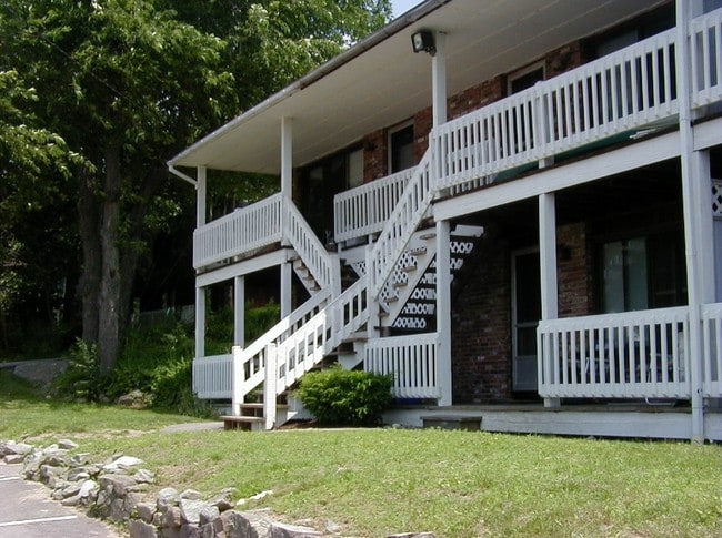
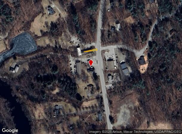
Property Record
2A N Main St, Newmarket, NH 03857
NEARBY LISTINGS FOR SALE OR LEASE
-
-
View all Newmarket listings for sale on LoopNet.com
Property Detail
2A N Main St
Commercialbuilding
Rockingham
X
New Hampshire
33015C0235F
0.23 AC
2024
Suburban Rockingham County
2024
Boston
067502
Boston-Cambridge-Newton, MA-NH
7,272 SF
NMAR-000002-000280-000000-U000000
DEMOGRAPHICS near 2A N Main St
1 Mile
3 Mile
5 Mile
2024 Total Population
3,778
12,479
34,465
2029 Population
3,917
12,988
35,905
Pop Growth 2024-2029
+ 3.68%
+ 4.08%
+ 4.18%
Average Age
41
41
37
2024 Total Households
1,777
5,271
11,371
HH Growth 2024-2029
+ 3.60%
+ 4.06%
+ 4.75%
Median Household Inc
$85,243
$102,023
$110,956
Avg Household Size
2.10
2.30
2.40
2024 Avg HH Vehicles
2.00
2.00
2.00
Median Home Value
$372,822
$395,493
$448,806
Median Year Built
1975
1981
1983
Nearby Places
Map Layers
Map Styles
 Street
 Aerial
- Restaurants
- Banks
- Shops
- Fitness
- Groceries
PUBLIC TRANSPORTATION
COMMUTER RAIL
Durham (Downeaster - Amtrak)
DRIVE
WALK
Distance
Durham (Downeaster - Amtrak)
11 min
4.3 mi
Exeter (Downeaster - Amtrak)
DRIVE
WALK
Distance
Exeter (Downeaster - Amtrak)
20 min
8.8 mi
AIRPORT
Portsmouth International at Pease
DRIVE
WALK
Distance
Portsmouth International at Pease
24 min
12.0 mi
Manchester Boston Regional
DRIVE
WALK
Distance
Manchester Boston Regional
60 min
37.9 mi
Freight Ports
Port of Boston
DRIVE
WALK
Distance
Port of Boston
87 min
60.9 mi
Nearby Properties
Address
Land Use
TOTAL SIZE
Lot Size
Zoning
Address
Land Use
TOTAL SIZE
Lot Size
Zoning
25.04 AC
RA
Address
Land Use
TOTAL SIZE
Lot Size
Zoning
389 AC
MUDOR
Address
Land Use
TOTAL SIZE
Lot Size
Zoning
358 AC
MUDOR
Address
Land Use
TOTAL SIZE
Lot Size
Zoning
0.45 AC
RB
Address
Land Use
TOTAL SIZE
Lot Size
Zoning
81,332 SF
16.41 AC
RB
Address
Land Use
TOTAL SIZE
Lot Size
Zoning
Address
Land Use
TOTAL SIZE
Lot Size
Zoning
103,968 SF
2.18 AC
M1
Address
Land Use
TOTAL SIZE
Lot Size
Zoning
77,254 SF
25.83 AC
M3
Address
Land Use
TOTAL SIZE
Lot Size
Zoning
34,095 SF
3 AC
B1
Address
Land Use
TOTAL SIZE
Lot Size
Zoning
31 AC
MUDOR
Address
Land Use
TOTAL SIZE
Lot Size
Zoning
25 AC
ORLI
Address
Land Use
TOTAL SIZE
Lot Size
Zoning
34,008 SF
5.22 AC
R3
Address
Land Use
TOTAL SIZE
Lot Size
Zoning
15,504 SF
8.10 AC
R3
Address
Land Use
TOTAL SIZE
Lot Size
Zoning
Address
Land Use
TOTAL SIZE
Lot Size
Zoning
36,192 SF
4.89 AC
R3
Address
Land Use
TOTAL SIZE
Lot Size
Zoning
22,546 SF
2.94 AC
R2
Address
Land Use
TOTAL SIZE
Lot Size
Zoning
50,960 SF
11.50 AC
R2
Address
Land Use
TOTAL SIZE
Lot Size
Zoning
16 AC
DBP
Address
Land Use
TOTAL SIZE
Lot Size
Zoning
44,568 SF
1 AC
R3
Address
Land Use
TOTAL SIZE
Lot Size
Zoning
3,078 SF
14.10 AC
M3
Address
Land Use
TOTAL SIZE
Lot Size
Zoning
31,608 SF
2.20 AC
R3
Address
Land Use
TOTAL SIZE
Lot Size
Zoning
9,240 SF
2.25 AC
R3
Address
Land Use
TOTAL SIZE
Lot Size
Zoning
34,008 SF
5.93 AC
R3
Address
Land Use
TOTAL SIZE
Lot Size
Zoning
25,194 SF
8.97 AC
R1
Address
Land Use
TOTAL SIZE
Lot Size
Zoning
29,606 SF
1.53 AC
R3
Address
Land Use
TOTAL SIZE
Lot Size
Zoning
22,488 SF
2.11 AC
R3
Address
Land Use
TOTAL SIZE
Lot Size
Zoning
19,200 SF
2.30 AC
R3
Address
Land Use
TOTAL SIZE
Lot Size
Zoning
144 SF
17 AC
R2
Address
Land Use
TOTAL SIZE
Lot Size
Zoning
23,212 SF
2.11 AC
R3
Address
Land Use
TOTAL SIZE
Lot Size
Zoning
10,260 SF
4.50 AC
B1
The World's #1 Commercial Real Estate Marketplace
Connect with us
© 2025 CoStar Group
The information above has been obtained from sources believed reliable. While we do not doubt its accuracy we have not verified it and make no guarantee, warranty or representation about it. It is your responsibility to independently confirm its accuracy and completeness. Any projections, opinions, assumptions, or estimates used are for example only and do not represent the current or future performance of the property. The value of this transaction to you depends on tax and other factors which should be evaluated by your tax, financial, and legal advisors. You and your advisors should conduct a careful, independent investigation of the property to determine to your satisfaction the suitability of the property for your needs.