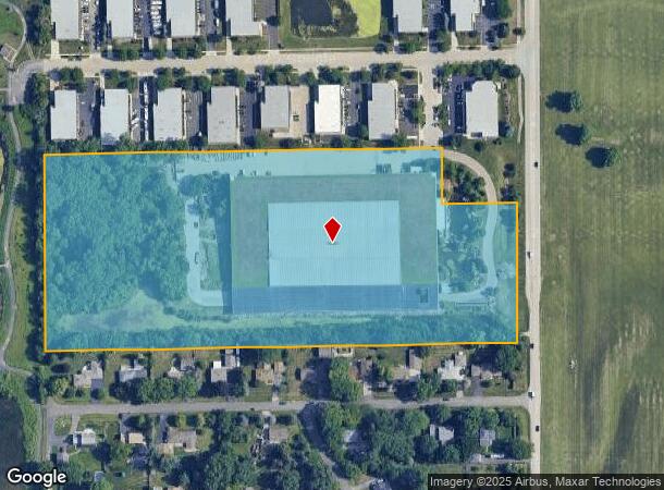
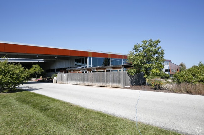
Property Record
2N322 Kautz Rd, Saint Charles, IL 60174

NEARBY LISTINGS FOR SALE OR LEASE
Property Detail
2N322 Kautz Rd
Chicago-Naperville-Elgin, IL-IN-WI
Aqualand
09-36-426-025
AQUALAND PART OF LT 1
Industrialgeneral
Kane
X
Illinois
17043C0019J
1
2024
14.88 AC
2024
Central Kane / DuPage
852005
Chicago
160,080 SF
DEMOGRAPHICS near 2N322 Kautz Rd
1 Mile
3 Mile
5 Mile
2024 Total Population
1,503
37,071
110,834
2029 Population
1,500
36,721
109,148
Pop Growth 2024-2029
(0.20%)
(0.94%)
(1.52%)
Average Age
39
43
41
2024 Total Households
524
14,333
40,311
HH Growth 2024-2029
(0.19%)
(0.95%)
(1.50%)
Median Household Inc
$103,835
$111,018
$111,374
Avg Household Size
2.80
2.50
2.70
2024 Avg HH Vehicles
2.00
2.00
2.00
Median Home Value
$295,953
$342,861
$344,357
Median Year Built
1987
1982
1982
Nearby Places
Map Layers
Map Styles
 Street
 Aerial
- Restaurants
- Banks
- Shops
- Fitness
- Groceries
PUBLIC TRANSPORTATION
COMMUTER RAIL
Geneva Station (Union Pacific West Line - Northeast Illinois Regional Commuter Railroad (Metra))
DRIVE
WALK
Distance
Geneva Station (Union Pacific West Line - Northeast Illinois Regional Commuter Railroad (Metra))
11 min
4.6 mi
West Chicago Station (Union Pacific West Line - Northeast Illinois Regional Commuter Railroad (Metra))
DRIVE
WALK
Distance
West Chicago Station (Union Pacific West Line - Northeast Illinois Regional Commuter Railroad (Metra))
13 min
5.7 mi
AIRPORT
Chicago O'Hare International
DRIVE
WALK
Distance
Chicago O'Hare International
47 min
29.0 mi
Chicago Midway International
DRIVE
WALK
Distance
Chicago Midway International
55 min
33.9 mi
Freight Ports
Port Milwaukee
DRIVE
WALK
Distance
Port Milwaukee
128 min
101.0 mi
Nearby Properties
Address
Land Use
TOTAL SIZE
Lot Size
Zoning
Address
Land Use
TOTAL SIZE
Lot Size
Zoning
5,482 SF
21.55 AC
Address
Land Use
TOTAL SIZE
Lot Size
Zoning
38.68 AC
Address
Land Use
TOTAL SIZE
Lot Size
Zoning
42.27 AC
Address
Land Use
TOTAL SIZE
Lot Size
Zoning
124,474 SF
25.38 AC
Address
Land Use
TOTAL SIZE
Lot Size
Zoning
715,000 SF
41.83 AC
Address
Land Use
TOTAL SIZE
Lot Size
Zoning
Address
Land Use
TOTAL SIZE
Lot Size
Zoning
26.41 AC
Address
Land Use
TOTAL SIZE
Lot Size
Zoning
Address
Land Use
TOTAL SIZE
Lot Size
Zoning
Address
Land Use
TOTAL SIZE
Lot Size
Zoning
75.23 AC
Address
Land Use
TOTAL SIZE
Lot Size
Zoning
11.08 AC
Address
Land Use
TOTAL SIZE
Lot Size
Zoning
667,636 SF
38 AC
Address
Land Use
TOTAL SIZE
Lot Size
Zoning
Address
Land Use
TOTAL SIZE
Lot Size
Zoning
291,360 SF
14.55 AC
Address
Land Use
TOTAL SIZE
Lot Size
Zoning
277,018 SF
12.36 AC
I
Address
Land Use
TOTAL SIZE
Lot Size
Zoning
Address
Land Use
TOTAL SIZE
Lot Size
Zoning
306,375 SF
23.82 AC
Address
Land Use
TOTAL SIZE
Lot Size
Zoning
18.30 AC
Address
Land Use
TOTAL SIZE
Lot Size
Zoning
21.14 AC
Address
Land Use
TOTAL SIZE
Lot Size
Zoning
258,240 SF
10.51 AC
Address
Land Use
TOTAL SIZE
Lot Size
Zoning
17.54 AC
Address
Land Use
TOTAL SIZE
Lot Size
Zoning
18.39 AC
Address
Land Use
TOTAL SIZE
Lot Size
Zoning
39.42 AC
Address
Land Use
TOTAL SIZE
Lot Size
Zoning
11.25 AC
Address
Land Use
TOTAL SIZE
Lot Size
Zoning
4,500 SF
11 AC
Address
Land Use
TOTAL SIZE
Lot Size
Zoning
240,824 SF
21.26 AC
Address
Land Use
TOTAL SIZE
Lot Size
Zoning
22.10 AC
Address
Land Use
TOTAL SIZE
Lot Size
Zoning
16.68 AC
I
Address
Land Use
TOTAL SIZE
Lot Size
Zoning
178,890 SF
34.20 AC
Address
Land Use
TOTAL SIZE
Lot Size
Zoning
168,302 SF
13.78 AC
I
The World's #1 Commercial Real Estate Marketplace
Connect with us
© 2026 CoStar Group
The information above has been obtained from sources believed reliable. While we do not doubt its accuracy we have not verified it and make no guarantee, warranty or representation about it. It is your responsibility to independently confirm its accuracy and completeness. Any projections, opinions, assumptions, or estimates used are for example only and do not represent the current or future performance of the property. The value of this transaction to you depends on tax and other factors which should be evaluated by your tax, financial, and legal advisors. You and your advisors should conduct a careful, independent investigation of the property to determine to your satisfaction the suitability of the property for your needs.