Property Record
2Nd Rd, Labelle, FL 33935

Property Detail
2Nd Rd
Clewiston, FL
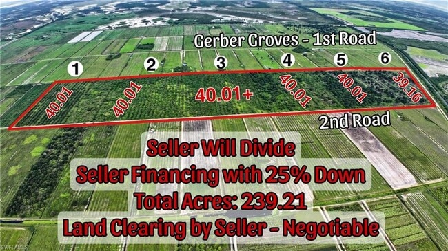
07-44-30 + 18-44-30 GERBER GROVES S/D SEC ONE BLK 4 TRACT 9 39.162 AC
1-30-44-04-010-0004-0040
HENDRY
Residentialacreage
Florida
A-2
6
2025
26.67 AC
2025
Florida Central South Area
000404
Other Market Areas
NEARBY LISTINGS FOR SALE OR LEASE
-
-
View all Labelle listings for sale on LoopNet.com
DEMOGRAPHICS near 2Nd Rd
1 mile
3 mile
5 mile
2025 Total Population
30
93
1,588
2030 Population
35
108
1,842
Pop Growth 2025-2030
+ 16.67%
+ 16.13%
+ 15.99%
Average Age
37
38
37
2025 Total Households
9
27
482
HH Growth 2025-2030
+ 11.11%
+ 18.52%
+ 17.84%
Median Household Inc
$42,500
$44,999
$50,256
Avg Household Size
2.80
2.90
2.90
2025 Avg HH Vehicles
3.00
2.00
2.00
Median Home Value
$199,999
$199,999
$193,656
Median Year Built
1997
1994
1994
Nearby Places
Map Layers
Map Styles
 Street
 Aerial
Transit
 Traffic
 Biking
Places
Listings with unknown addresses are not visible on the map
- Restaurants
- Banks
- Shops
- Fitness
- Groceries
PUBLIC TRANSPORTATION
AIRPORT
Southwest Florida International
Drive
Walk
Distance
Southwest Florida International
64 min
39.7 mi
Freight Ports
Port of Palm Beach
Drive
Walk
Distance
Port of Palm Beach
166 min
111.6 mi
Nearby Properties
Address
Land Use
TOTAL SIZE
Lot Size
Zoning
Address
Land Use
TOTAL SIZE
Lot Size
Zoning
634 AC
A-2
Address
Land Use
TOTAL SIZE
Lot Size
Zoning
429.10 AC
A-2
Address
Land Use
TOTAL SIZE
Lot Size
Zoning
25,200 SF
18.84 AC
A-2
Address
Land Use
TOTAL SIZE
Lot Size
Zoning
211.72 AC
PUD
Address
Land Use
TOTAL SIZE
Lot Size
Zoning
209.29 AC
A-2
Address
Land Use
TOTAL SIZE
Lot Size
Zoning
14,800 SF
10.29 AC
A-2
Address
Land Use
TOTAL SIZE
Lot Size
Zoning
1,848 SF
654.22 AC
A-2
Address
Land Use
TOTAL SIZE
Lot Size
Zoning
780 SF
634 AC
A-2
Address
Land Use
TOTAL SIZE
Lot Size
Zoning
8,424 SF
159.05 AC
A-2
Address
Land Use
TOTAL SIZE
Lot Size
Zoning
1,196 SF
640 AC
A-2
Address
Land Use
TOTAL SIZE
Lot Size
Zoning
1,168 SF
496.77 AC
A-2
Address
Land Use
TOTAL SIZE
Lot Size
Zoning
123.30 AC
A-2
Address
Land Use
TOTAL SIZE
Lot Size
Zoning
500 SF
89.25 AC
A-2
Address
Land Use
TOTAL SIZE
Lot Size
Zoning
50.08 AC
A-2
Address
Land Use
TOTAL SIZE
Lot Size
Zoning
49.46 AC
A-2
Address
Land Use
TOTAL SIZE
Lot Size
Zoning
591 AC
A-2
Address
Land Use
TOTAL SIZE
Lot Size
Zoning
46.53 AC
A-2
Address
Land Use
TOTAL SIZE
Lot Size
Zoning
10,000 SF
10.08 AC
A-2
Address
Land Use
TOTAL SIZE
Lot Size
Zoning
40.01 AC
A-2
Address
Land Use
TOTAL SIZE
Lot Size
Zoning
40.01 AC
A-2
Address
Land Use
TOTAL SIZE
Lot Size
Zoning
40.01 AC
A-2
Address
Land Use
TOTAL SIZE
Lot Size
Zoning
40.01 AC
A-2
Address
Land Use
TOTAL SIZE
Lot Size
Zoning
40.01 AC
A-2
Address
Land Use
TOTAL SIZE
Lot Size
Zoning
40.01 AC
A-2
Address
Land Use
TOTAL SIZE
Lot Size
Zoning
40.01 AC
A-2
Address
Land Use
TOTAL SIZE
Lot Size
Zoning
48.78 AC
A-2
Address
Land Use
TOTAL SIZE
Lot Size
Zoning
40.01 AC
A-2
Address
Land Use
TOTAL SIZE
Lot Size
Zoning
39.16 AC
A-2
Address
Land Use
TOTAL SIZE
Lot Size
Zoning
39.02 AC
A-2
Address
Land Use
TOTAL SIZE
Lot Size
Zoning
6,218 SF
3.60 AC
A-2
The World's #1 Commercial Real Estate Marketplace
Connect with us
© 2026 CoStar Group
The information above has been obtained from sources believed reliable. While we do not doubt its accuracy we have not verified it and make no guarantee, warranty or representation about it. It is your responsibility to independently confirm its accuracy and completeness. Any projections, opinions, assumptions, or estimates used are for example only and do not represent the current or future performance of the property. The value of this transaction to you depends on tax and other factors which should be evaluated by your tax, financial, and legal advisors. You and your advisors should conduct a careful, independent investigation of the property to determine to your satisfaction the suitability of the property for your needs.