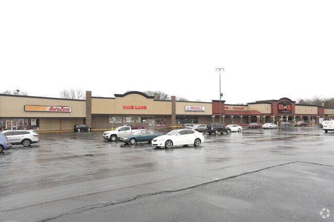
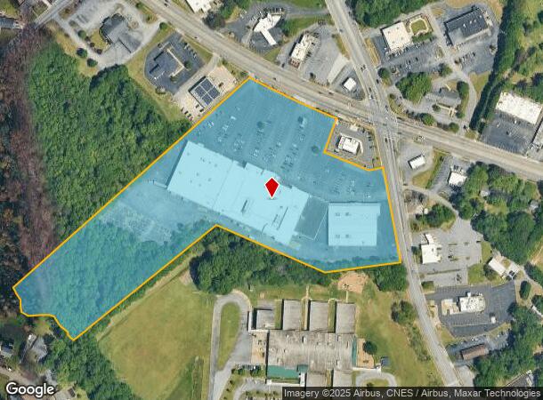
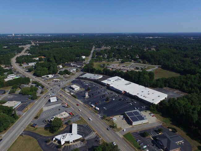
Property Record
15 W Parker Rd, Greenville, SC 29611

NEARBY LISTINGS FOR SALE OR LEASE
Property Detail
15 W Parker Rd
Greenville-Anderson-Mauldin, SC
Farrs Bridge
B016.00-03-006.01
MAP B016.00
Stripcommercialcenter
Greenville
AE
South Carolina
45045C0314E
006.01
2025
12.28 AC
2024
West Greenville
003601
Greenville/Spartanburg
DEMOGRAPHICS near 15 W Parker Rd
1 Mile
3 Mile
5 Mile
2024 Total Population
7,167
51,961
118,865
2029 Population
7,905
57,604
131,811
Pop Growth 2024-2029
+ 10.30%
+ 10.86%
+ 10.89%
Average Age
38
38
39
2024 Total Households
2,606
20,549
48,612
HH Growth 2024-2029
+ 10.51%
+ 10.89%
+ 11.23%
Median Household Inc
$41,209
$42,233
$50,081
Avg Household Size
2.50
2.40
2.30
2024 Avg HH Vehicles
2.00
2.00
2.00
Median Home Value
$147,457
$157,362
$211,014
Median Year Built
1980
1979
1982
Nearby Places
Map Layers
Map Styles
 Street
 Aerial
- Restaurants
- Banks
- Shops
- Fitness
- Groceries
PUBLIC TRANSPORTATION
COMMUTER RAIL
Greenville Amtrak Station (Crescent - Amtrak)
DRIVE
WALK
Distance
Greenville Amtrak Station (Crescent - Amtrak)
7 min
3.5 mi
AIRPORT
Greenville Spartanburg International
DRIVE
WALK
Distance
Greenville Spartanburg International
30 min
18.0 mi
Freight Ports
North Charleston Terminal
DRIVE
WALK
Distance
North Charleston Terminal
237 min
208.6 mi
SALE & LEASE HISTORY
LISTING DATE
SALE/LEASE

Sep 25, 2016
For Lease
Jun 02, 2017
For Lease
Jul 27, 2017
For Lease
Jul 07, 2022
For Lease
Jan 31, 2020
For Lease
Jan 09, 2018
For Lease
Apr 05, 2019
For Lease
Nearby Properties
Address
Land Use
TOTAL SIZE
Lot Size
Zoning
Address
Land Use
TOTAL SIZE
Lot Size
Zoning
22.97 AC
R12
Address
Land Use
TOTAL SIZE
Lot Size
Zoning
14.41 AC
R15
Address
Land Use
TOTAL SIZE
Lot Size
Zoning
20.04 AC
RM
Address
Land Use
TOTAL SIZE
Lot Size
Zoning
10.10 AC
RM
Address
Land Use
TOTAL SIZE
Lot Size
Zoning
10.17 AC
RM
Address
Land Use
TOTAL SIZE
Lot Size
Zoning
2.14 AC
RM
Address
Land Use
TOTAL SIZE
Lot Size
Zoning
2.21 AC
RMA
Address
Land Use
TOTAL SIZE
Lot Size
Zoning
50.95 AC
R75
Address
Land Use
TOTAL SIZE
Lot Size
Zoning
8.29 AC
I1
Address
Land Use
TOTAL SIZE
Lot Size
Zoning
4.97 AC
RM20
Address
Land Use
TOTAL SIZE
Lot Size
Zoning
15.60 AC
I1
Address
Land Use
TOTAL SIZE
Lot Size
Zoning
22.92 AC
R10
Address
Land Use
TOTAL SIZE
Lot Size
Zoning
8.40 AC
I1
Address
Land Use
TOTAL SIZE
Lot Size
Zoning
1.08 AC
C3
Address
Land Use
TOTAL SIZE
Lot Size
Zoning
1.83 AC
RM
Address
Land Use
TOTAL SIZE
Lot Size
Zoning
165.20 AC
RS
Address
Land Use
TOTAL SIZE
Lot Size
Zoning
18.22 AC
RM
Address
Land Use
TOTAL SIZE
Lot Size
Zoning
16.81 AC
I1
Address
Land Use
TOTAL SIZE
Lot Size
Zoning
14.46 AC
RM
Address
Land Use
TOTAL SIZE
Lot Size
Zoning
22.88 AC
C2
Address
Land Use
TOTAL SIZE
Lot Size
Zoning
5.05 AC
C2
Address
Land Use
TOTAL SIZE
Lot Size
Zoning
1.43 AC
C1N
Address
Land Use
TOTAL SIZE
Lot Size
Zoning
153.11 AC
R10
Address
Land Use
TOTAL SIZE
Lot Size
Zoning
0.47 AC
PD
Address
Land Use
TOTAL SIZE
Lot Size
Zoning
1,410 SF
10.17 AC
R10
Address
Land Use
TOTAL SIZE
Lot Size
Zoning
1.76 AC
S1
Address
Land Use
TOTAL SIZE
Lot Size
Zoning
15.82 AC
Address
Land Use
TOTAL SIZE
Lot Size
Zoning
100 AC
RS
Address
Land Use
TOTAL SIZE
Lot Size
Zoning
5.10 AC
C2
Address
Land Use
TOTAL SIZE
Lot Size
Zoning
3,008 SF
25.76 AC
C1
The World's #1 Commercial Real Estate Marketplace
Connect with us
© 2025 CoStar Group
The information above has been obtained from sources believed reliable. While we do not doubt its accuracy we have not verified it and make no guarantee, warranty or representation about it. It is your responsibility to independently confirm its accuracy and completeness. Any projections, opinions, assumptions, or estimates used are for example only and do not represent the current or future performance of the property. The value of this transaction to you depends on tax and other factors which should be evaluated by your tax, financial, and legal advisors. You and your advisors should conduct a careful, independent investigation of the property to determine to your satisfaction the suitability of the property for your needs.