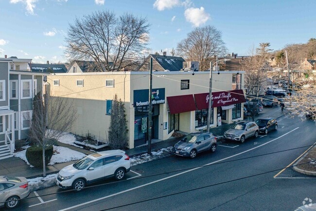
Property Record
39 Lexington St, Belmont, MA 02478


Current Lease Availabilities
NEARBY LISTINGS FOR SALE OR LEASE
Property Detail
39 Lexington St
BELM-000033-000013
Middlesex
Storebuilding
Massachusetts
X
0.21 AC
25017C0414F
Lexington/Arlington
2025
Boston
2025
Boston-Cambridge-Newton, MA-NH
357800
DEMOGRAPHICS near 39 Lexington St
1 Mile
3 Mile
5 Mile
2024 Total Population
23,445
198,629
555,923
2029 Population
23,054
195,576
544,920
Pop Growth 2024-2029
(1.67%)
(1.54%)
(1.98%)
Average Age
40
40
39
2024 Total Households
8,654
81,930
227,645
HH Growth 2024-2029
(1.93%)
(1.64%)
(2.17%)
Median Household Inc
$117,205
$121,163
$118,927
Avg Household Size
2.40
2.30
2.30
2024 Avg HH Vehicles
2.00
1.00
1.00
Median Home Value
$786,489
$818,572
$891,135
Median Year Built
1947
1950
1949
Nearby Places
Map Layers
Map Styles
 Street
 Aerial
- Restaurants
- Banks
- Shops
- Fitness
- Groceries
PUBLIC TRANSPORTATION
TRANSIT/SUBWAY
Waverley (Fitchburg/South Acton Line - Massachusetts Bay Transportation Authority Commuter Rail (Purple Line))
DRIVE
WALK
Distance
Waverley (Fitchburg/South Acton Line - Massachusetts Bay Transportation Authority Commuter Rail (Purple Line))
1 min
3 min
0.1 mi
COMMUTER RAIL
Waverley (Fitchburg/South Acton Line - Massachusetts Bay Transportation Authority Commuter Rail (Purple Line))
DRIVE
WALK
Distance
Waverley (Fitchburg/South Acton Line - Massachusetts Bay Transportation Authority Commuter Rail (Purple Line))
1 min
2 min
0.1 mi
Belmont Center (Fitchburg/South Acton Line - Massachusetts Bay Transportation Authority Commuter Rail (Purple Line))
DRIVE
WALK
Distance
Belmont Center (Fitchburg/South Acton Line - Massachusetts Bay Transportation Authority Commuter Rail (Purple Line))
3 min
1.3 mi
AIRPORT
General Edward Lawrence Logan International
DRIVE
WALK
Distance
General Edward Lawrence Logan International
22 min
12.4 mi
Worcester Regional
DRIVE
WALK
Distance
Worcester Regional
64 min
44.4 mi
Freight Ports
Port of Boston
DRIVE
WALK
Distance
Port of Boston
21 min
10.7 mi
Nearby Properties
Address
Land Use
TOTAL SIZE
Lot Size
Zoning
Address
Land Use
TOTAL SIZE
Lot Size
Zoning
776,099 SF
35.70 AC
Address
Land Use
TOTAL SIZE
Lot Size
Zoning
283,554 SF
2.76 AC
O-2A
Address
Land Use
TOTAL SIZE
Lot Size
Zoning
54,500 SF
4.01 AC
O-2A
Address
Land Use
TOTAL SIZE
Lot Size
Zoning
336,518 SF
6.15 AC
I-3
Address
Land Use
TOTAL SIZE
Lot Size
Zoning
2.87 AC
O-2A
Address
Land Use
TOTAL SIZE
Lot Size
Zoning
220,671 SF
2.52 AC
I-2
Address
Land Use
TOTAL SIZE
Lot Size
Zoning
213,834 SF
1.48 AC
SD-4
Address
Land Use
TOTAL SIZE
Lot Size
Zoning
165,986 SF
4.32 AC
Address
Land Use
TOTAL SIZE
Lot Size
Zoning
224,115 SF
2.35 AC
O-2A
Address
Land Use
TOTAL SIZE
Lot Size
Zoning
472,329 SF
22.11 AC
CD
Address
Land Use
TOTAL SIZE
Lot Size
Zoning
244,008 SF
4 AC
SD-4A
Address
Land Use
TOTAL SIZE
Lot Size
Zoning
176,625 SF
5.76 AC
I-3
Address
Land Use
TOTAL SIZE
Lot Size
Zoning
105,982 SF
4.50 AC
Address
Land Use
TOTAL SIZE
Lot Size
Zoning
117,783 SF
0.63 AC
Address
Land Use
TOTAL SIZE
Lot Size
Zoning
387,965 SF
3.90 AC
Address
Land Use
TOTAL SIZE
Lot Size
Zoning
21.52 AC
Address
Land Use
TOTAL SIZE
Lot Size
Zoning
12.90 AC
R
Address
Land Use
TOTAL SIZE
Lot Size
Zoning
16.79 AC
BA
Address
Land Use
TOTAL SIZE
Lot Size
Zoning
155,866 SF
2.60 AC
O-1
Address
Land Use
TOTAL SIZE
Lot Size
Zoning
145,839 SF
1.81 AC
O-2A
Address
Land Use
TOTAL SIZE
Lot Size
Zoning
234,814 SF
4.06 AC
Address
Land Use
TOTAL SIZE
Lot Size
Zoning
25,000 SF
25.73 AC
RD
Address
Land Use
TOTAL SIZE
Lot Size
Zoning
253,440 SF
3.20 AC
C-3
Address
Land Use
TOTAL SIZE
Lot Size
Zoning
79.60 AC
SD
Address
Land Use
TOTAL SIZE
Lot Size
Zoning
73.10 AC
SA
Address
Land Use
TOTAL SIZE
Lot Size
Zoning
179,834 SF
8.57 AC
PUB
Address
Land Use
TOTAL SIZE
Lot Size
Zoning
218,825 SF
2.93 AC
O-2A
Address
Land Use
TOTAL SIZE
Lot Size
Zoning
139,520 SF
1.21 AC
SD-4
Address
Land Use
TOTAL SIZE
Lot Size
Zoning
191,142 SF
1.08 AC
A
Address
Land Use
TOTAL SIZE
Lot Size
Zoning
44.94 AC
R2
The World's #1 Commercial Real Estate Marketplace
Connect with us
© 2025 CoStar Group
The information above has been obtained from sources believed reliable. While we do not doubt its accuracy we have not verified it and make no guarantee, warranty or representation about it. It is your responsibility to independently confirm its accuracy and completeness. Any projections, opinions, assumptions, or estimates used are for example only and do not represent the current or future performance of the property. The value of this transaction to you depends on tax and other factors which should be evaluated by your tax, financial, and legal advisors. You and your advisors should conduct a careful, independent investigation of the property to determine to your satisfaction the suitability of the property for your needs.