Property Record
3 Andover Rd, Glenmoore, PA 19343

NEARBY LISTINGS FOR SALE OR LEASE
Property Detail
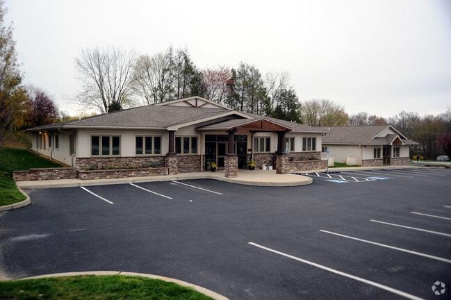
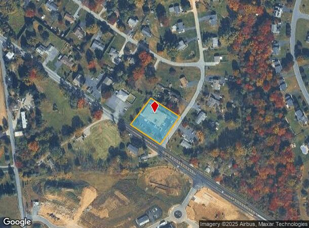
3 Andover Rd
Philadelphia-Camden-Wilmington, PA-NJ-DE-MD
Combustion Maintenance Svcs In
29-04G-0021.0100
1.1 AC & COMM BLDG LOT 1
Officebuilding
Chester
X
Pennsylvania
42029C0140G
1
2024
1.10 AC
2025
Exton/Whitelands
311404
Philadelphia
8,374 SF
DEMOGRAPHICS near 3 Andover Rd
1 Mile
3 Mile
5 Mile
2024 Total Population
2,397
18,153
55,230
2029 Population
2,508
18,951
57,550
Pop Growth 2024-2029
+ 4.63%
+ 4.40%
+ 4.20%
Average Age
43
43
42
2024 Total Households
866
6,543
20,181
HH Growth 2024-2029
+ 4.73%
+ 4.57%
+ 4.38%
Median Household Inc
$118,277
$119,166
$104,147
Avg Household Size
2.70
2.70
2.70
2024 Avg HH Vehicles
2.00
2.00
2.00
Median Home Value
$359,142
$406,879
$355,637
Median Year Built
1987
1990
1987
Nearby Places
Map Layers
Map Styles
 Street
 Aerial
- Restaurants
- Banks
- Shops
- Fitness
- Groceries
PUBLIC TRANSPORTATION
COMMUTER RAIL
Thorndale (R5 - Southeastern Pennsylvania Transportation Authority Regional Rail (SEPTA Regional Rail))
DRIVE
WALK
Distance
Thorndale (R5 - Southeastern Pennsylvania Transportation Authority Regional Rail (SEPTA Regional Rail))
12 min
5.6 mi
Coatesville Amtrak (Keystone Service - Amtrak)
DRIVE
WALK
Distance
Coatesville Amtrak (Keystone Service - Amtrak)
15 min
7.4 mi
Freight Ports
Port of Wilmington, RI
DRIVE
WALK
Distance
Port of Wilmington, RI
60 min
35.3 mi
Nearby Properties
Address
Land Use
TOTAL SIZE
Lot Size
Zoning
Address
Land Use
TOTAL SIZE
Lot Size
Zoning
812,454 SF
29.70 AC
MS1
Address
Land Use
TOTAL SIZE
Lot Size
Zoning
107,208 SF
30.63 AC
R2
Address
Land Use
TOTAL SIZE
Lot Size
Zoning
87,400 SF
27.13 AC
R
Address
Land Use
TOTAL SIZE
Lot Size
Zoning
54,004 SF
51.66 AC
R2
Address
Land Use
TOTAL SIZE
Lot Size
Zoning
65,027 SF
30.60 AC
MS1
Address
Land Use
TOTAL SIZE
Lot Size
Zoning
83,541 SF
11.43 AC
R2
Address
Land Use
TOTAL SIZE
Lot Size
Zoning
74,093 SF
57.80 AC
FR
Address
Land Use
TOTAL SIZE
Lot Size
Zoning
54,290 SF
18.60 AC
R2
Address
Land Use
TOTAL SIZE
Lot Size
Zoning
53.40 AC
LI
Address
Land Use
TOTAL SIZE
Lot Size
Zoning
48,231 SF
81.50 AC
FR
Address
Land Use
TOTAL SIZE
Lot Size
Zoning
15,676 SF
16.10 AC
R2
Address
Land Use
TOTAL SIZE
Lot Size
Zoning
19,157 SF
260.50 AC
FR
Address
Land Use
TOTAL SIZE
Lot Size
Zoning
23,831 SF
10.49 AC
R3
Address
Land Use
TOTAL SIZE
Lot Size
Zoning
16,642 SF
2 AC
VC
Address
Land Use
TOTAL SIZE
Lot Size
Zoning
28,302 SF
5.20 AC
LI
Address
Land Use
TOTAL SIZE
Lot Size
Zoning
25,886 SF
56.52 AC
R3
Address
Land Use
TOTAL SIZE
Lot Size
Zoning
21,214 SF
3.63 AC
R3
Address
Land Use
TOTAL SIZE
Lot Size
Zoning
4,006 SF
154.31 AC
R2
Address
Land Use
TOTAL SIZE
Lot Size
Zoning
26,260 SF
2 AC
R2
Address
Land Use
TOTAL SIZE
Lot Size
Zoning
6,538 SF
130 AC
NC
Address
Land Use
TOTAL SIZE
Lot Size
Zoning
9,985 SF
43.37 AC
LI
Address
Land Use
TOTAL SIZE
Lot Size
Zoning
12,557 SF
13.52 AC
R2
Address
Land Use
TOTAL SIZE
Lot Size
Zoning
21,979 SF
11.90 AC
LI
Address
Land Use
TOTAL SIZE
Lot Size
Zoning
10,000 SF
1.75 AC
R2
Address
Land Use
TOTAL SIZE
Lot Size
Zoning
23,942 SF
6.90 AC
NC
Address
Land Use
TOTAL SIZE
Lot Size
Zoning
28,778 SF
6.80 AC
LI
Address
Land Use
TOTAL SIZE
Lot Size
Zoning
19,200 SF
18.50 AC
R2
Address
Land Use
TOTAL SIZE
Lot Size
Zoning
126.73 AC
R3
Address
Land Use
TOTAL SIZE
Lot Size
Zoning
10,856 SF
2.60 AC
R2
Address
Land Use
TOTAL SIZE
Lot Size
Zoning
7,310 SF
15.40 AC
R2
The World's #1 Commercial Real Estate Marketplace
Connect with us
© 2025 CoStar Group
The information above has been obtained from sources believed reliable. While we do not doubt its accuracy we have not verified it and make no guarantee, warranty or representation about it. It is your responsibility to independently confirm its accuracy and completeness. Any projections, opinions, assumptions, or estimates used are for example only and do not represent the current or future performance of the property. The value of this transaction to you depends on tax and other factors which should be evaluated by your tax, financial, and legal advisors. You and your advisors should conduct a careful, independent investigation of the property to determine to your satisfaction the suitability of the property for your needs.