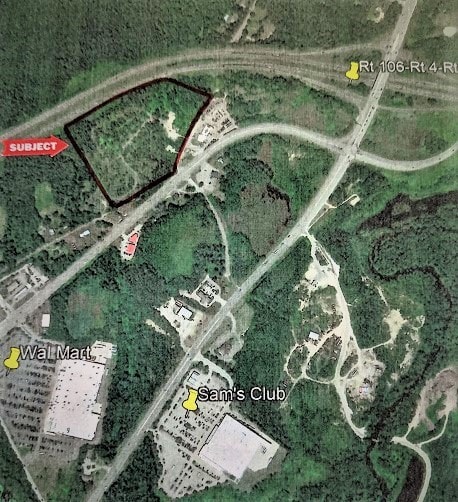
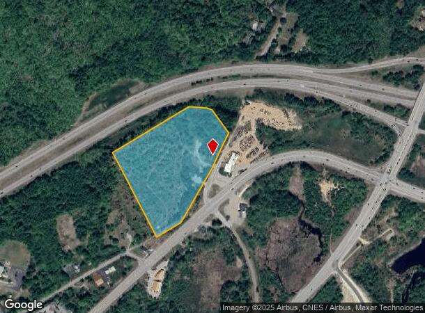
Property Record
37 Break O Day Dr, Concord, NH 03301
NEARBY LISTINGS FOR SALE OR LEASE
Property Detail
37 Break O Day Dr
CNCD M:46Z B:36
Merrimack
Commercialnec
New Hampshire
X
12.87 AC
33013C0551E
Concord/New Hampshire North Area
2025
Other Market Areas
2025
Concord, NH
032400
DEMOGRAPHICS near 37 Break O Day Dr
1 mile
3 mile
5 mile
2024 Total Population
468
12,019
38,488
2029 Population
495
12,585
40,456
Pop Growth 2024-2029
+ 5.77%
+ 4.71%
+ 5.11%
Average Age
43
44
43
2024 Total Households
215
5,243
16,178
HH Growth 2024-2029
+ 6.05%
+ 4.56%
+ 5.17%
Median Household Inc
$83,776
$68,956
$73,700
Avg Household Size
2.20
2.20
2.20
2024 Avg HH Vehicles
2.00
2.00
2.00
Median Home Value
$320,000
$284,163
$303,526
Median Year Built
1984
1981
1971
Nearby Places
Map Layers
Map Styles
 Street
 Aerial
Transit
 Traffic
 Biking
Places
Listings with unknown addresses are not visible on the map
- Restaurants
- Banks
- Shops
- Fitness
- Groceries
PUBLIC TRANSPORTATION
AIRPORT
Manchester Boston Regional
Drive
Walk
Distance
Manchester Boston Regional
44 min
27.3 mi
Freight Ports
Port of Boston
Drive
Walk
Distance
Port of Boston
109 min
75.8 mi
SALE & LEASE HISTORY
LISTING DATE
SALE/LEASE

Sep 23, 2021
For Sale
Dec 03, 2019
For Sale
Nearby Properties
Address
Land Use
TOTAL SIZE
Lot Size
Zoning
Address
Land Use
TOTAL SIZE
Lot Size
Zoning
196 AC
IS
Address
Land Use
TOTAL SIZE
Lot Size
Zoning
1,500 SF
RO
Address
Land Use
TOTAL SIZE
Lot Size
Zoning
293,984 SF
IS
Address
Land Use
TOTAL SIZE
Lot Size
Zoning
156 AC
IS
Address
Land Use
TOTAL SIZE
Lot Size
Zoning
65.25 AC
IN
Address
Land Use
TOTAL SIZE
Lot Size
Zoning
20 AC
RH
Address
Land Use
TOTAL SIZE
Lot Size
Zoning
11,576 SF
191 AC
C-1A
Address
Land Use
TOTAL SIZE
Lot Size
Zoning
41.49 AC
CG
Address
Land Use
TOTAL SIZE
Lot Size
Zoning
194,386 SF
33.30 AC
GWP
Address
Land Use
TOTAL SIZE
Lot Size
Zoning
10.85 AC
GWP
Address
Land Use
TOTAL SIZE
Lot Size
Zoning
13.23 AC
RH
Address
Land Use
TOTAL SIZE
Lot Size
Zoning
142,137 SF
10.23 AC
OFP
Address
Land Use
TOTAL SIZE
Lot Size
Zoning
21.45 AC
RH
Address
Land Use
TOTAL SIZE
Lot Size
Zoning
121,292 SF
10.69 AC
GWP
Address
Land Use
TOTAL SIZE
Lot Size
Zoning
41.95 AC
IN
Address
Land Use
TOTAL SIZE
Lot Size
Zoning
26.72 AC
IN
Address
Land Use
TOTAL SIZE
Lot Size
Zoning
7.48 AC
RM
Address
Land Use
TOTAL SIZE
Lot Size
Zoning
50.19 AC
GWP
Address
Land Use
TOTAL SIZE
Lot Size
Zoning
34.94 AC
RM
Address
Land Use
TOTAL SIZE
Lot Size
Zoning
136,536 SF
17.69 AC
GWP
Address
Land Use
TOTAL SIZE
Lot Size
Zoning
135,161 SF
36.20 AC
GWP
Address
Land Use
TOTAL SIZE
Lot Size
Zoning
114,620 SF
12.89 AC
GWP
Address
Land Use
TOTAL SIZE
Lot Size
Zoning
100,826 SF
0.64 AC
IS
Address
Land Use
TOTAL SIZE
Lot Size
Zoning
65,868 SF
10.40 AC
GWP
Address
Land Use
TOTAL SIZE
Lot Size
Zoning
98,070 SF
0.94 AC
IS
Address
Land Use
TOTAL SIZE
Lot Size
Zoning
7,475 SF
49.90 AC
C-1D
Address
Land Use
TOTAL SIZE
Lot Size
Zoning
8.58 AC
GWP
Address
Land Use
TOTAL SIZE
Lot Size
Zoning
15.55 AC
IN
Address
Land Use
TOTAL SIZE
Lot Size
Zoning
6.04 AC
GWP
Address
Land Use
TOTAL SIZE
Lot Size
Zoning
The World's #1 Commercial Real Estate Marketplace
Connect with us
© 2026 CoStar Group
The information above has been obtained from sources believed reliable. While we do not doubt its accuracy we have not verified it and make no guarantee, warranty or representation about it. It is your responsibility to independently confirm its accuracy and completeness. Any projections, opinions, assumptions, or estimates used are for example only and do not represent the current or future performance of the property. The value of this transaction to you depends on tax and other factors which should be evaluated by your tax, financial, and legal advisors. You and your advisors should conduct a careful, independent investigation of the property to determine to your satisfaction the suitability of the property for your needs.