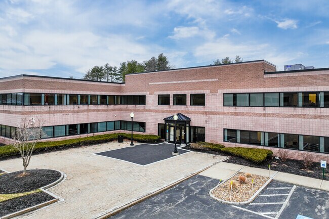
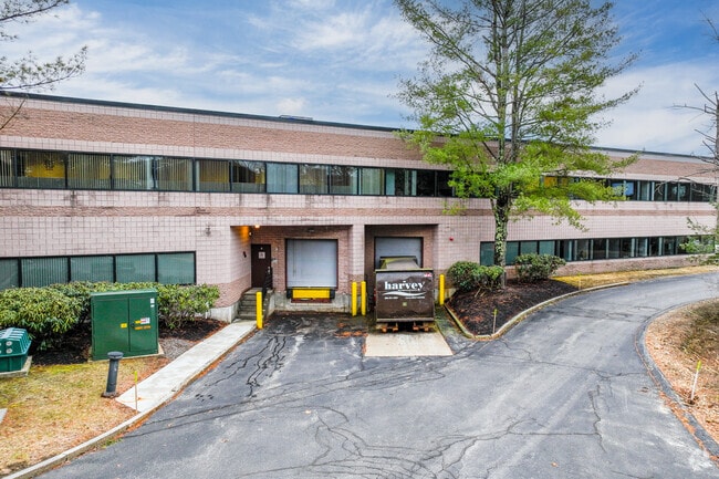
Property Record
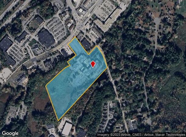
3 Carlisle Rd, Westford, MA 01886
NEARBY LISTINGS FOR SALE OR LEASE
Property Detail
3 Carlisle Rd
Commercialnec
Middlesex
A
Massachusetts
25017C0233G
18.41 AC
2025
Lowell/Chelmsford
2025
Boston
318400
Boston-Cambridge-Newton, MA-NH
161,850 SF
WFOR-000017-000080
DEMOGRAPHICS near 3 Carlisle Rd
1 Mile
3 Mile
5 Mile
2024 Total Population
1,500
23,827
70,401
2029 Population
1,489
23,628
70,051
Pop Growth 2024-2029
(0.73%)
(0.84%)
(0.50%)
Average Age
42
42
42
2024 Total Households
539
8,663
26,027
HH Growth 2024-2029
(0.93%)
(0.91%)
(0.60%)
Median Household Inc
$152,303
$156,851
$148,063
Avg Household Size
2.70
2.70
2.70
2024 Avg HH Vehicles
2.00
2.00
2.00
Median Home Value
$712,673
$661,336
$653,163
Median Year Built
1993
1985
1977
Nearby Places
Map Layers
Map Styles
 Street
 Aerial
- Restaurants
- Banks
- Shops
- Fitness
- Groceries
PUBLIC TRANSPORTATION
COMMUTER RAIL
Littleton/Route 495 (Fitchburg/South Acton Line - Massachusetts Bay Transportation Authority Commuter Rail (Purple Line))
DRIVE
WALK
Distance
Littleton/Route 495 (Fitchburg/South Acton Line - Massachusetts Bay Transportation Authority Commuter Rail (Purple Line))
11 min
5.7 mi
Lowell (Lowell Line - Massachusetts Bay Transportation Authority Commuter Rail (Purple Line))
DRIVE
WALK
Distance
Lowell (Lowell Line - Massachusetts Bay Transportation Authority Commuter Rail (Purple Line))
13 min
8.4 mi
AIRPORT
Manchester Boston Regional
DRIVE
WALK
Distance
Manchester Boston Regional
48 min
30.9 mi
Worcester Regional
DRIVE
WALK
Distance
Worcester Regional
51 min
37.4 mi
General Edward Lawrence Logan International
DRIVE
WALK
Distance
General Edward Lawrence Logan International
51 min
39.5 mi
SALE & LEASE HISTORY
LISTING DATE
SALE/LEASE

Sep 06, 2018
For Lease
Mar 08, 2018
For Lease
Nearby Properties
Address
Land Use
TOTAL SIZE
Lot Size
Zoning
Address
Land Use
TOTAL SIZE
Lot Size
Zoning
310,328 SF
22.24 AC
IH
Address
Land Use
TOTAL SIZE
Lot Size
Zoning
236,297 SF
17.62 AC
CH
Address
Land Use
TOTAL SIZE
Lot Size
Zoning
205,340 SF
44.73 AC
RA
Address
Land Use
TOTAL SIZE
Lot Size
Zoning
279,042 SF
37.90 AC
RA
Address
Land Use
TOTAL SIZE
Lot Size
Zoning
255,627 SF
82.71 AC
RA
Address
Land Use
TOTAL SIZE
Lot Size
Zoning
8.39 AC
OP1
Address
Land Use
TOTAL SIZE
Lot Size
Zoning
220,257 SF
24.17 AC
CH
Address
Land Use
TOTAL SIZE
Lot Size
Zoning
39.84 AC
B
Address
Land Use
TOTAL SIZE
Lot Size
Zoning
7.32 AC
R
Address
Land Use
TOTAL SIZE
Lot Size
Zoning
7.41 AC
CB
Address
Land Use
TOTAL SIZE
Lot Size
Zoning
137,558 SF
68.80 AC
RA
Address
Land Use
TOTAL SIZE
Lot Size
Zoning
14.47 AC
R108
Address
Land Use
TOTAL SIZE
Lot Size
Zoning
85,450 SF
32.07 AC
RA
Address
Land Use
TOTAL SIZE
Lot Size
Zoning
9.48 AC
RB
Address
Land Use
TOTAL SIZE
Lot Size
Zoning
291,926 SF
31.78 AC
IH
Address
Land Use
TOTAL SIZE
Lot Size
Zoning
230,037 SF
18.85 AC
IH
Address
Land Use
TOTAL SIZE
Lot Size
Zoning
64,542 SF
4.67 AC
CH
Address
Land Use
TOTAL SIZE
Lot Size
Zoning
9.96 AC
OP1
Address
Land Use
TOTAL SIZE
Lot Size
Zoning
79,254 SF
18.14 AC
RA
Address
Land Use
TOTAL SIZE
Lot Size
Zoning
73,576 SF
26.14 AC
P
Address
Land Use
TOTAL SIZE
Lot Size
Zoning
155,922 SF
14.61 AC
CH
Address
Land Use
TOTAL SIZE
Lot Size
Zoning
396,023 SF
23.53 AC
OP1
Address
Land Use
TOTAL SIZE
Lot Size
Zoning
181,578 SF
11.40 AC
IH
Address
Land Use
TOTAL SIZE
Lot Size
Zoning
171,494 SF
15.68 AC
CH
Address
Land Use
TOTAL SIZE
Lot Size
Zoning
87,430 SF
9.30 AC
CH
Address
Land Use
TOTAL SIZE
Lot Size
Zoning
130,524 SF
19.74 AC
IH
Address
Land Use
TOTAL SIZE
Lot Size
Zoning
8.54 AC
CB
Address
Land Use
TOTAL SIZE
Lot Size
Zoning
66,447 SF
11.59 AC
B
Address
Land Use
TOTAL SIZE
Lot Size
Zoning
175,718 SF
20.12 AC
IH
The World's #1 Commercial Real Estate Marketplace
Connect with us
© 2026 CoStar Group
The information above has been obtained from sources believed reliable. While we do not doubt its accuracy we have not verified it and make no guarantee, warranty or representation about it. It is your responsibility to independently confirm its accuracy and completeness. Any projections, opinions, assumptions, or estimates used are for example only and do not represent the current or future performance of the property. The value of this transaction to you depends on tax and other factors which should be evaluated by your tax, financial, and legal advisors. You and your advisors should conduct a careful, independent investigation of the property to determine to your satisfaction the suitability of the property for your needs.