Property Record
3 Chalet Rd, Middleboro, MA 02346

Property Detail
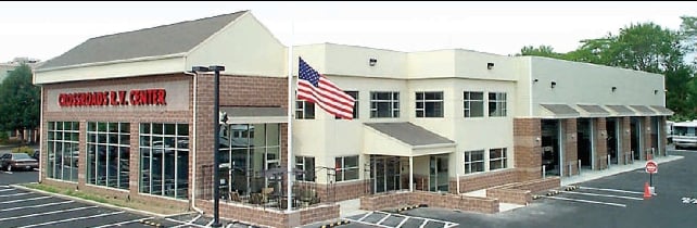
3 Chalet Rd
MIDD-000038-006384
Plymouth
Vehiclerentalsvehiclesales
Massachusetts
B and X Area of moderate flood hazard, usually the area between the limits of the 100-year and 500-year floods.
6384
2025
2 AC
2025
Route 3 South
542200
Boston
17,778 SF
Boston-Cambridge-Newton, MA-NH
NEARBY LISTINGS FOR SALE OR LEASE
DEMOGRAPHICS near 3 Chalet Rd
1 mile
3 mile
5 mile
2025 Total Population
321
15,799
50,301
2030 Population
328
16,130
51,361
Pop Growth 2025-2030
+ 2.18%
+ 2.10%
+ 2.11%
Average Age
43
41
43
2025 Total Households
115
5,994
18,369
HH Growth 2025-2030
+ 2.61%
+ 2.00%
+ 2.11%
Median Household Inc
$89,814
$99,014
$107,003
Avg Household Size
2.70
2.60
2.60
2025 Avg HH Vehicles
2.00
2.00
2.00
Median Home Value
$669,491
$550,242
$492,627
Median Year Built
1981
1978
1982
Nearby Places
Map Layers
Map Styles
 Street
 Aerial
Layers
 Traffic
 Biking
Places
Listings with unknown addresses are not visible on the map
- Restaurants
- Banks
- Shops
- Fitness
- Groceries
PUBLIC TRANSPORTATION
COMMUTER RAIL
Middleborough/Lakeville (Middleborough/Lakeville Line - Massachusetts Bay Transportation Authority Commuter Rail (Purple Line))
Drive
Walk
Distance
Middleborough/Lakeville (Middleborough/Lakeville Line - Massachusetts Bay Transportation Authority Commuter Rail (Purple Line))
6 min
3.5 mi
Bridgewater (Middleborough/Lakeville Line - Massachusetts Bay Transportation Authority Commuter Rail (Purple Line))
Drive
Walk
Distance
Bridgewater (Middleborough/Lakeville Line - Massachusetts Bay Transportation Authority Commuter Rail (Purple Line))
16 min
8.0 mi
AIRPORT
Rhode Island Tf Green International
Drive
Walk
Distance
Rhode Island Tf Green International
54 min
31.9 mi
Freight Ports
Port of New Bedford Harbor
Drive
Walk
Distance
Port of New Bedford Harbor
34 min
21.7 mi
Nearby Properties
Address
Land Use
TOTAL SIZE
Lot Size
Zoning
Address
Land Use
TOTAL SIZE
Lot Size
Zoning
34.41 AC
Address
Land Use
TOTAL SIZE
Lot Size
Zoning
815,324 SF
88.80 AC
Address
Land Use
TOTAL SIZE
Lot Size
Zoning
158,638 SF
54.12 AC
Address
Land Use
TOTAL SIZE
Lot Size
Zoning
575,572 SF
119.44 AC
Address
Land Use
TOTAL SIZE
Lot Size
Zoning
178.18 AC
OPSPAC
Address
Land Use
TOTAL SIZE
Lot Size
Zoning
137,710 SF
26.66 AC
Address
Land Use
TOTAL SIZE
Lot Size
Zoning
10,680 SF
79.73 AC
Address
Land Use
TOTAL SIZE
Lot Size
Zoning
257,810 SF
20.62 AC
Address
Land Use
TOTAL SIZE
Lot Size
Zoning
7.41 AC
Address
Land Use
TOTAL SIZE
Lot Size
Zoning
108,990 SF
6.18 AC
Address
Land Use
TOTAL SIZE
Lot Size
Zoning
64,023 SF
3.48 AC
Address
Land Use
TOTAL SIZE
Lot Size
Zoning
58,937 SF
5.49 AC
Address
Land Use
TOTAL SIZE
Lot Size
Zoning
123,378 SF
15.59 AC
Address
Land Use
TOTAL SIZE
Lot Size
Zoning
149,089 SF
22.71 AC
Address
Land Use
TOTAL SIZE
Lot Size
Zoning
20.37 AC
Address
Land Use
TOTAL SIZE
Lot Size
Zoning
42,133 SF
17.68 AC
Address
Land Use
TOTAL SIZE
Lot Size
Zoning
159,630 SF
10.91 AC
Address
Land Use
TOTAL SIZE
Lot Size
Zoning
34,800 SF
3.53 AC
Address
Land Use
TOTAL SIZE
Lot Size
Zoning
79,947 SF
27.31 AC
Address
Land Use
TOTAL SIZE
Lot Size
Zoning
89,979 SF
18.52 AC
Address
Land Use
TOTAL SIZE
Lot Size
Zoning
82,400 SF
19.12 AC
Address
Land Use
TOTAL SIZE
Lot Size
Zoning
10,779 SF
1.53 AC
Address
Land Use
TOTAL SIZE
Lot Size
Zoning
89,506 SF
23.63 AC
Address
Land Use
TOTAL SIZE
Lot Size
Zoning
3.05 AC
Address
Land Use
TOTAL SIZE
Lot Size
Zoning
2.68 AC
Address
Land Use
TOTAL SIZE
Lot Size
Zoning
35,805 SF
4.18 AC
Address
Land Use
TOTAL SIZE
Lot Size
Zoning
67,224 SF
4.04 AC
Address
Land Use
TOTAL SIZE
Lot Size
Zoning
39,230 SF
12.57 AC
Address
Land Use
TOTAL SIZE
Lot Size
Zoning
173,200 SF
14.21 AC
HIWABZ
Address
Land Use
TOTAL SIZE
Lot Size
Zoning
19,794 SF
144.57 AC
The World's #1 Commercial Real Estate Marketplace
Connect with us
© 2026 CoStar Group
The information above has been obtained from sources believed reliable. While we do not doubt its accuracy we have not verified it and make no guarantee, warranty or representation about it. It is your responsibility to independently confirm its accuracy and completeness. Any projections, opinions, assumptions, or estimates used are for example only and do not represent the current or future performance of the property. The value of this transaction to you depends on tax and other factors which should be evaluated by your tax, financial, and legal advisors. You and your advisors should conduct a careful, independent investigation of the property to determine to your satisfaction the suitability of the property for your needs.