Property Record
3 Chopt Rd, Henrico, VA 23233

NEARBY LISTINGS FOR SALE OR LEASE
Property Detail
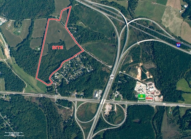
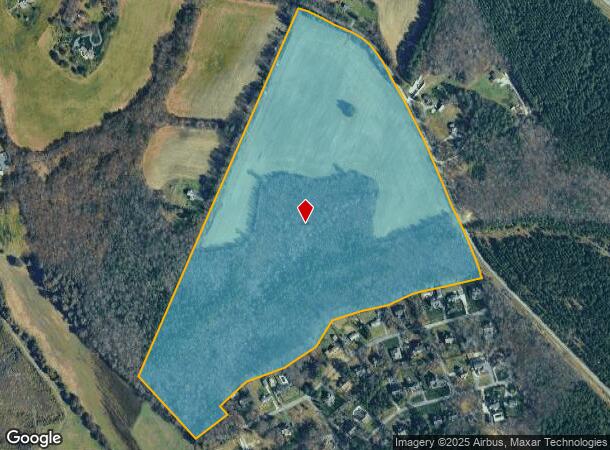
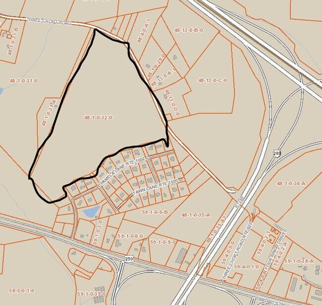
3 Chopt Rd
48-1-32
E CENTERVL ON 622 60AC #23-3254 PCF 94-66
Agriculturalland
Goochland
AE
Virginia
51075C0241C
60 AC
2025
West Creek
2025
Richmond VA
400102
Richmond, VA
DEMOGRAPHICS near 3 Chopt Rd
1 Mile
3 Mile
5 Mile
2024 Total Population
436
27,475
80,105
2029 Population
505
28,431
81,403
Pop Growth 2024-2029
+ 15.83%
+ 3.48%
+ 1.62%
Average Age
50
40
40
2024 Total Households
198
10,138
30,240
HH Growth 2024-2029
+ 15.66%
+ 3.94%
+ 1.87%
Median Household Inc
$128,289
$143,241
$127,345
Avg Household Size
2.20
2.70
2.60
2024 Avg HH Vehicles
2.00
2.00
2.00
Median Home Value
$625,000
$633,837
$489,646
Median Year Built
2007
2000
1996
Nearby Places
Map Layers
Map Styles
 Street
 Aerial
- Restaurants
- Banks
- Shops
- Fitness
- Groceries
PUBLIC TRANSPORTATION
AIRPORT
Richmond International
DRIVE
WALK
Distance
Richmond International
40 min
27.0 mi
Freight Ports
Virginia Port Authority - Richmond
DRIVE
WALK
Distance
Virginia Port Authority - Richmond
38 min
25.3 mi
SALE & LEASE HISTORY
LISTING DATE
SALE/LEASE

Sep 24, 2016
For Sale
Oct 26, 2020
For Sale
Jul 27, 2023
For Sale
Aug 25, 2019
For Sale
Nearby Properties
Address
Land Use
TOTAL SIZE
Lot Size
Zoning
Address
Land Use
TOTAL SIZE
Lot Size
Zoning
10,290 SF
56.53 AC
B-3C
Address
Land Use
TOTAL SIZE
Lot Size
Zoning
3,300 SF
286.94 AC
M1-INDUS/L
Address
Land Use
TOTAL SIZE
Lot Size
Zoning
93.75 AC
M1-INDUS/L
Address
Land Use
TOTAL SIZE
Lot Size
Zoning
37.36 AC
R-5C
Address
Land Use
TOTAL SIZE
Lot Size
Zoning
227,483 SF
12.10 AC
M1-INDUS/L
Address
Land Use
TOTAL SIZE
Lot Size
Zoning
112,224 SF
20.53 AC
MIXE
Address
Land Use
TOTAL SIZE
Lot Size
Zoning
3,077 SF
19.89 AC
M1-INDUS/L
Address
Land Use
TOTAL SIZE
Lot Size
Zoning
340 SF
23.32 AC
MIXE
Address
Land Use
TOTAL SIZE
Lot Size
Zoning
282,400 SF
18.71 AC
MIXE
Address
Land Use
TOTAL SIZE
Lot Size
Zoning
289,752 SF
24.72 AC
R-5C
Address
Land Use
TOTAL SIZE
Lot Size
Zoning
243,000 SF
130.85 AC
M1-INDUS/L
Address
Land Use
TOTAL SIZE
Lot Size
Zoning
55,769 SF
14.13 AC
MIXE
Address
Land Use
TOTAL SIZE
Lot Size
Zoning
111,487 SF
2.92 AC
B-2C
Address
Land Use
TOTAL SIZE
Lot Size
Zoning
164,680 SF
33.86 AC
MIXE
Address
Land Use
TOTAL SIZE
Lot Size
Zoning
20,864 SF
15.28 AC
MIXE
Address
Land Use
TOTAL SIZE
Lot Size
Zoning
176,520 SF
17.61 AC
R-5
Address
Land Use
TOTAL SIZE
Lot Size
Zoning
10,282 SF
2.13 AC
B-3C
Address
Land Use
TOTAL SIZE
Lot Size
Zoning
58,446 SF
12.71 AC
B-3C
Address
Land Use
TOTAL SIZE
Lot Size
Zoning
187,283 SF
5.22 AC
B-2C
Address
Land Use
TOTAL SIZE
Lot Size
Zoning
74,305 SF
6.05 AC
M1-INDUS/L
Address
Land Use
TOTAL SIZE
Lot Size
Zoning
124,140 SF
6.10 AC
R-6C
Address
Land Use
TOTAL SIZE
Lot Size
Zoning
78,400 SF
29.68 AC
A-1
Address
Land Use
TOTAL SIZE
Lot Size
Zoning
118,959 SF
7.69 AC
B-3C
Address
Land Use
TOTAL SIZE
Lot Size
Zoning
122,852 SF
13.71 AC
B-3C
Address
Land Use
TOTAL SIZE
Lot Size
Zoning
84,050 SF
9.81 AC
B-2
Address
Land Use
TOTAL SIZE
Lot Size
Zoning
103,104 SF
6.59 AC
MIXE
Address
Land Use
TOTAL SIZE
Lot Size
Zoning
78,558 SF
23.15 AC
A-1
Address
Land Use
TOTAL SIZE
Lot Size
Zoning
49,576 SF
20.96 AC
MIXE
Address
Land Use
TOTAL SIZE
Lot Size
Zoning
125,409 SF
8.55 AC
MIXE
Address
Land Use
TOTAL SIZE
Lot Size
Zoning
59,066 SF
9.19 AC
C
The World's #1 Commercial Real Estate Marketplace
Connect with us
© 2025 CoStar Group
The information above has been obtained from sources believed reliable. While we do not doubt its accuracy we have not verified it and make no guarantee, warranty or representation about it. It is your responsibility to independently confirm its accuracy and completeness. Any projections, opinions, assumptions, or estimates used are for example only and do not represent the current or future performance of the property. The value of this transaction to you depends on tax and other factors which should be evaluated by your tax, financial, and legal advisors. You and your advisors should conduct a careful, independent investigation of the property to determine to your satisfaction the suitability of the property for your needs.