Property Record
3 Commonwealth Ave, Attleboro, MA 02703
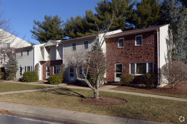
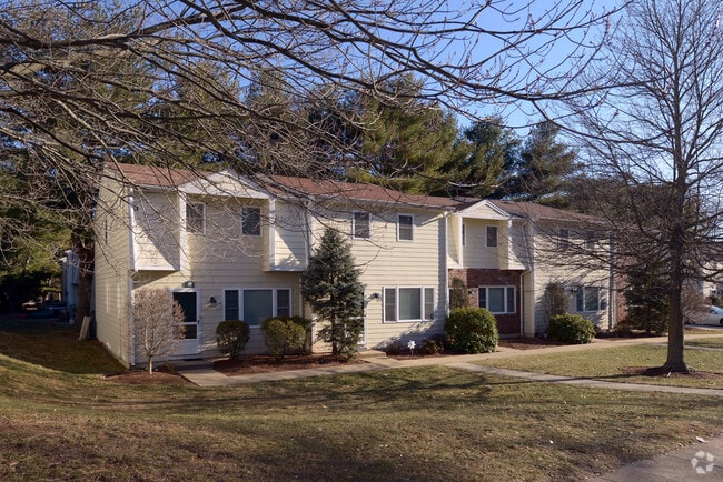
Property Detail
3 Commonwealth Ave
ATTL-000092-000000-000007
Bristol
Apartment
Massachusetts
B and X Area of moderate flood hazard, usually the area between the limits of the 100-year and 500-year floods.
7
2025
0.13 AC
2025
Outlying Bristol County
631300
Boston
11,016 SF
Providence-Warwick, RI-MA
NEARBY LISTINGS FOR SALE OR LEASE
-
-
View all Attleboro listings for sale on LoopNet.com
DEMOGRAPHICS near 3 Commonwealth Ave
1 mile
3 mile
5 mile
2025 Total Population
4,973
58,424
99,911
2030 Population
5,071
59,638
102,024
Pop Growth 2025-2030
+ 1.97%
+ 2.08%
+ 2.11%
Average Age
42
41
42
2025 Total Households
1,840
23,472
38,861
HH Growth 2025-2030
+ 1.90%
+ 2.12%
+ 2.16%
Median Household Inc
$125,240
$95,431
$105,352
Avg Household Size
2.70
2.40
2.50
2025 Avg HH Vehicles
2.00
2.00
2.00
Median Home Value
$596,087
$483,175
$511,133
Median Year Built
1974
1971
1976
Nearby Places
Map Layers
Map Styles
 Street
 Aerial
Transit
 Traffic
 Biking
Places
Listings with unknown addresses are not visible on the map
- Restaurants
- Banks
- Shops
- Fitness
- Groceries
PUBLIC TRANSPORTATION
COMMUTER RAIL
Attleboro (Foxboro Event Service - MBTA, Providence/Stoughton Line - MBTA)
Drive
Walk
Distance
Attleboro (Foxboro Event Service - MBTA, Providence/Stoughton Line - MBTA)
5 min
2.2 mi
Mansfield (Foxboro Line (Special Events Only) - Massachusetts Bay Transportation Authority Commuter Rail (Purple Line), Providence/Stoughton Line - Massachusetts Bay Transportation Authority Commuter Rail (Purple Line))
Drive
Walk
Distance
Mansfield (Foxboro Line (Special Events Only) - Massachusetts Bay Transportation Authority Commuter Rail (Purple Line), Providence/Stoughton Line - Massachusetts Bay Transportation Authority Commuter Rail (Purple Line))
13 min
7.9 mi
AIRPORT
Rhode Island Tf Green International
Drive
Walk
Distance
Rhode Island Tf Green International
36 min
22.4 mi
Freight Ports
Port of Davisville, RI
Drive
Walk
Distance
Port of Davisville, RI
52 min
34.7 mi
Nearby Properties
Address
Land Use
TOTAL SIZE
Lot Size
Zoning
Address
Land Use
TOTAL SIZE
Lot Size
Zoning
65.21 AC
Address
Land Use
TOTAL SIZE
Lot Size
Zoning
98,369 SF
5.53 AC
IC30
Address
Land Use
TOTAL SIZE
Lot Size
Zoning
10.40 AC
Address
Land Use
TOTAL SIZE
Lot Size
Zoning
17,782 SF
25.60 AC
Address
Land Use
TOTAL SIZE
Lot Size
Zoning
Address
Land Use
TOTAL SIZE
Lot Size
Zoning
228,377 SF
24.19 AC
IND
Address
Land Use
TOTAL SIZE
Lot Size
Zoning
228,377 SF
24.19 AC
IND
Address
Land Use
TOTAL SIZE
Lot Size
Zoning
8,432 SF
46 AC
Address
Land Use
TOTAL SIZE
Lot Size
Zoning
146,400 SF
1.50 AC
CB
Address
Land Use
TOTAL SIZE
Lot Size
Zoning
11,110 SF
25.74 AC
Address
Land Use
TOTAL SIZE
Lot Size
Zoning
112,766 SF
31.06 AC
Address
Land Use
TOTAL SIZE
Lot Size
Zoning
70,663 SF
8.80 AC
Address
Land Use
TOTAL SIZE
Lot Size
Zoning
8.29 AC
R10
Address
Land Use
TOTAL SIZE
Lot Size
Zoning
79,322 SF
12.54 AC
R15
Address
Land Use
TOTAL SIZE
Lot Size
Zoning
16.82 AC
C60
Address
Land Use
TOTAL SIZE
Lot Size
Zoning
9.52 AC
C7.5
Address
Land Use
TOTAL SIZE
Lot Size
Zoning
76,785 SF
1.17 AC
GB
Address
Land Use
TOTAL SIZE
Lot Size
Zoning
164,001 SF
22.80 AC
Address
Land Use
TOTAL SIZE
Lot Size
Zoning
6.88 AC
CA
Address
Land Use
TOTAL SIZE
Lot Size
Zoning
12,958 SF
5.50 AC
Address
Land Use
TOTAL SIZE
Lot Size
Zoning
91,126 SF
9.71 AC
I60
Address
Land Use
TOTAL SIZE
Lot Size
Zoning
36,424 SF
1.18 AC
IC3
Address
Land Use
TOTAL SIZE
Lot Size
Zoning
53,375 SF
10.14 AC
IC30
Address
Land Use
TOTAL SIZE
Lot Size
Zoning
104,003 SF
9.92 AC
I60
Address
Land Use
TOTAL SIZE
Lot Size
Zoning
1,656 SF
4.66 AC
R15
Address
Land Use
TOTAL SIZE
Lot Size
Zoning
5,760 SF
23.95 AC
Address
Land Use
TOTAL SIZE
Lot Size
Zoning
7,364 SF
8.60 AC
Address
Land Use
TOTAL SIZE
Lot Size
Zoning
3.59 AC
IC3
Address
Land Use
TOTAL SIZE
Lot Size
Zoning
76,295 SF
3.66 AC
I
Address
Land Use
TOTAL SIZE
Lot Size
Zoning
13,555 SF
14.70 AC
I
The World's #1 Commercial Real Estate Marketplace
Connect with us
© 2026 CoStar Group
The information above has been obtained from sources believed reliable. While we do not doubt its accuracy we have not verified it and make no guarantee, warranty or representation about it. It is your responsibility to independently confirm its accuracy and completeness. Any projections, opinions, assumptions, or estimates used are for example only and do not represent the current or future performance of the property. The value of this transaction to you depends on tax and other factors which should be evaluated by your tax, financial, and legal advisors. You and your advisors should conduct a careful, independent investigation of the property to determine to your satisfaction the suitability of the property for your needs.