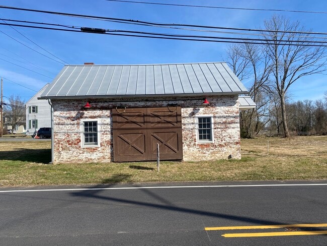
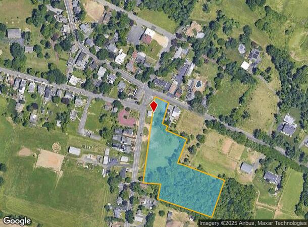
Property Record
3 Cross-Chesterfield Rd, Chesterfield, NJ 08515
NEARBY LISTINGS FOR SALE OR LEASE
Property Detail
3 Cross-Chesterfield Rd
Philadelphia-Camden-Wilmington, PA-NJ-DE-MD
ADDITIONAL LOTS: BLACKSMITH SHOP HIST
07-00302-0000-00001
Burlington
Vacantlandnec
New Jersey
X
1
34005C0044F
3.28 AC
2024
South Burlington County
2025
Philadelphia
704302
DEMOGRAPHICS near 3 Cross-Chesterfield Rd
1 Mile
3 Mile
5 Mile
2024 Total Population
1,889
23,996
69,900
2029 Population
1,892
24,039
69,754
Pop Growth 2024-2029
+ 0.16%
+ 0.18%
(0.21%)
Average Age
37
39
42
2024 Total Households
591
7,668
26,200
HH Growth 2024-2029
(0.17%)
+ 0.04%
(0.36%)
Median Household Inc
$177,604
$115,400
$104,336
Avg Household Size
3.20
2.70
2.50
2024 Avg HH Vehicles
2.00
2.00
2.00
Median Home Value
$469,506
$366,470
$322,081
Median Year Built
2001
1979
1971
Nearby Places
Map Layers
Map Styles
 Street
 Aerial
- Restaurants
- Banks
- Shops
- Fitness
- Groceries
PUBLIC TRANSPORTATION
COMMUTER RAIL
Trenton Transit Center (NJT) (Northeast Corridor Line - NJ Transit Commuter Rail (NJ Transit), River LINE - River LINE (River LINE))
DRIVE
WALK
Distance
Trenton Transit Center (NJT) (Northeast Corridor Line - NJ Transit Commuter Rail (NJ Transit), River LINE - River LINE (River LINE))
18 min
8.5 mi
DRIVE
WALK
Distance
15 min
9.1 mi
AIRPORT
Trenton Mercer
DRIVE
WALK
Distance
Trenton Mercer
26 min
15.1 mi
Philadelphia International
DRIVE
WALK
Distance
Philadelphia International
65 min
43.6 mi
Freight Ports
South Jersey Port
DRIVE
WALK
Distance
South Jersey Port
47 min
33.4 mi
SALE & LEASE HISTORY
LISTING DATE
SALE/LEASE

Apr 03, 2024
For Sale
Nearby Properties
Address
Land Use
TOTAL SIZE
Lot Size
Zoning
Address
Land Use
TOTAL SIZE
Lot Size
Zoning
561.91 AC
AG
Address
Land Use
TOTAL SIZE
Lot Size
Zoning
31.05 AC
Address
Land Use
TOTAL SIZE
Lot Size
Zoning
30.94 AC
Address
Land Use
TOTAL SIZE
Lot Size
Zoning
51.10 AC
Address
Land Use
TOTAL SIZE
Lot Size
Zoning
2,030 SF
45.57 AC
Address
Land Use
TOTAL SIZE
Lot Size
Zoning
Address
Land Use
TOTAL SIZE
Lot Size
Zoning
134,000 SF
117.90 AC
AR
Address
Land Use
TOTAL SIZE
Lot Size
Zoning
32.71 AC
HC
Address
Land Use
TOTAL SIZE
Lot Size
Zoning
2,350 SF
8.80 AC
PVD2
Address
Land Use
TOTAL SIZE
Lot Size
Zoning
Address
Land Use
TOTAL SIZE
Lot Size
Zoning
Address
Land Use
TOTAL SIZE
Lot Size
Zoning
55.49 AC
RD
Address
Land Use
TOTAL SIZE
Lot Size
Zoning
15,096 SF
21.76 AC
AT
Address
Land Use
TOTAL SIZE
Lot Size
Zoning
Address
Land Use
TOTAL SIZE
Lot Size
Zoning
50,438 SF
9.32 AC
HC
Address
Land Use
TOTAL SIZE
Lot Size
Zoning
Address
Land Use
TOTAL SIZE
Lot Size
Zoning
18,427 SF
6.71 AC
HC
Address
Land Use
TOTAL SIZE
Lot Size
Zoning
51,000 SF
6.78 AC
Address
Land Use
TOTAL SIZE
Lot Size
Zoning
4.12 AC
Address
Land Use
TOTAL SIZE
Lot Size
Zoning
Address
Land Use
TOTAL SIZE
Lot Size
Zoning
6.93 AC
HC
Address
Land Use
TOTAL SIZE
Lot Size
Zoning
63.51 AC
RRC
Address
Land Use
TOTAL SIZE
Lot Size
Zoning
11.43 AC
Address
Land Use
TOTAL SIZE
Lot Size
Zoning
459 SF
38.99 AC
R15
Address
Land Use
TOTAL SIZE
Lot Size
Zoning
5.93 AC
CC
Address
Land Use
TOTAL SIZE
Lot Size
Zoning
22,542 SF
4.18 AC
HC
Address
Land Use
TOTAL SIZE
Lot Size
Zoning
13.46 AC
RD
Address
Land Use
TOTAL SIZE
Lot Size
Zoning
1,768 SF
14.09 AC
Address
Land Use
TOTAL SIZE
Lot Size
Zoning
Address
Land Use
TOTAL SIZE
Lot Size
Zoning
14,860 SF
19.80 AC
RRC
The World's #1 Commercial Real Estate Marketplace
Connect with us
© 2025 CoStar Group
The information above has been obtained from sources believed reliable. While we do not doubt its accuracy we have not verified it and make no guarantee, warranty or representation about it. It is your responsibility to independently confirm its accuracy and completeness. Any projections, opinions, assumptions, or estimates used are for example only and do not represent the current or future performance of the property. The value of this transaction to you depends on tax and other factors which should be evaluated by your tax, financial, and legal advisors. You and your advisors should conduct a careful, independent investigation of the property to determine to your satisfaction the suitability of the property for your needs.