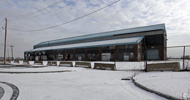
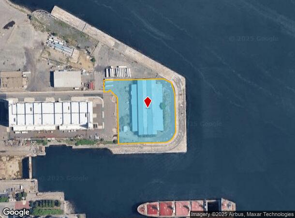
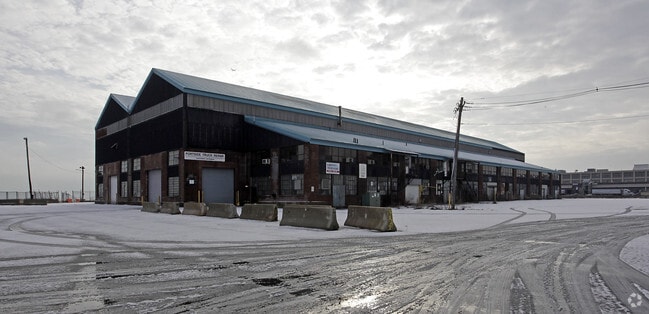
Property Record
3 Dolphin Way, Boston, MA 02210
NEARBY LISTINGS FOR SALE OR LEASE
Property Detail
3 Dolphin Way
Taxexempt
Suffolk
AE
Massachusetts
25025C0082J
3.09 AC
0
Ft Pt Chan/S Boston
2025
Boston
981202
Boston-Cambridge-Newton, MA-NH
101,304 SF
SBOS-000000-000006-002674-000090
DEMOGRAPHICS near 3 Dolphin Way
1 Mile
3 Mile
5 Mile
2024 Total Population
7,288
227,194
697,484
2029 Population
6,993
218,224
669,099
Pop Growth 2024-2029
(4.05%)
(3.95%)
(4.07%)
Average Age
36
39
37
2024 Total Households
3,521
106,820
287,930
HH Growth 2024-2029
(4.12%)
(4.16%)
(4.23%)
Median Household Inc
$145,617
$105,555
$83,812
Avg Household Size
2.00
2.00
2.20
2024 Avg HH Vehicles
1.00
1.00
1.00
Median Home Value
$794,419
$839,899
$758,347
Median Year Built
1949
1954
1949
Nearby Places
Map Layers
Map Styles
 Street
 Aerial
- Restaurants
- Banks
- Shops
- Fitness
- Groceries
PUBLIC TRANSPORTATION
COMMUTER RAIL
South Station (Fairmount Line - Massachusetts Bay Transportation Authority Commuter Rail (Purple Line), Framingham/Worcester Line - Massachusetts Bay Transportation Authority Commuter Rail (Purple Line), Franklin Line - Massachusetts Bay Transportation Authority Commuter Rail (Purple Line), Greenbush Line - Massachusetts Bay Transportation Authority Commuter Rail (Purple Line), Kingston/Plymouth Line - Massachusetts Bay Transportation Authority Commuter Rail (Purple Line), Middleborough/Lakeville Line - Massachusetts Bay Transportation Authority Commuter Rail (Purple Line), Needham Line - Massachusetts Bay Transportation Authority Commuter Rail (Purple Line), Providence/Stoughton Line - Massachusetts Bay Transportation Authority Commuter Rail (Purple Line))
DRIVE
WALK
Distance
South Station (Fairmount Line - Massachusetts Bay Transportation Authority Commuter Rail (Purple Line), Framingham/Worcester Line - Massachusetts Bay Transportation Authority Commuter Rail (Purple Line), Franklin Line - Massachusetts Bay Transportation Authority Commuter Rail (Purple Line), Greenbush Line - Massachusetts Bay Transportation Authority Commuter Rail (Purple Line), Kingston/Plymouth Line - Massachusetts Bay Transportation Authority Commuter Rail (Purple Line), Middleborough/Lakeville Line - Massachusetts Bay Transportation Authority Commuter Rail (Purple Line), Needham Line - Massachusetts Bay Transportation Authority Commuter Rail (Purple Line), Providence/Stoughton Line - Massachusetts Bay Transportation Authority Commuter Rail (Purple Line))
6 min
2.0 mi
North Station (Fitchburg/South Acton Line - Massachusetts Bay Transportation Authority Commuter Rail (Purple Line), Haverhill Line - Massachusetts Bay Transportation Authority Commuter Rail (Purple Line), Lowell Line - Massachusetts Bay Transportation Authority Commuter Rail (Purple Line), Newburyport/Rockport Line - Massachusetts Bay Transportation Authority Commuter Rail (Purple Line))
DRIVE
WALK
Distance
North Station (Fitchburg/South Acton Line - Massachusetts Bay Transportation Authority Commuter Rail (Purple Line), Haverhill Line - Massachusetts Bay Transportation Authority Commuter Rail (Purple Line), Lowell Line - Massachusetts Bay Transportation Authority Commuter Rail (Purple Line), Newburyport/Rockport Line - Massachusetts Bay Transportation Authority Commuter Rail (Purple Line))
9 min
2.9 mi
AIRPORT
General Edward Lawrence Logan International
DRIVE
WALK
Distance
General Edward Lawrence Logan International
9 min
4.3 mi
Freight Ports
Port of Boston
DRIVE
WALK
Distance
Port of Boston
4 min
0.9 mi
Nearby Properties
Address
Land Use
TOTAL SIZE
Lot Size
Zoning
Address
Land Use
TOTAL SIZE
Lot Size
Zoning
408,667 SF
3.27 AC
C
Address
Land Use
TOTAL SIZE
Lot Size
Zoning
825,000 SF
5.17 AC
E
Address
Land Use
TOTAL SIZE
Lot Size
Zoning
6.39 AC
C
Address
Land Use
TOTAL SIZE
Lot Size
Zoning
171,791 SF
166.88 AC
E
Address
Land Use
TOTAL SIZE
Lot Size
Zoning
334,522 SF
1.26 AC
C
Address
Land Use
TOTAL SIZE
Lot Size
Zoning
312,269 SF
0.43 AC
C
Address
Land Use
TOTAL SIZE
Lot Size
Zoning
46,259 SF
1.05 AC
E
Address
Land Use
TOTAL SIZE
Lot Size
Zoning
118,759 SF
0.92 AC
C
Address
Land Use
TOTAL SIZE
Lot Size
Zoning
1.13 AC
C
Address
Land Use
TOTAL SIZE
Lot Size
Zoning
3.75 AC
C
Address
Land Use
TOTAL SIZE
Lot Size
Zoning
448,796 SF
1.84 AC
C
Address
Land Use
TOTAL SIZE
Lot Size
Zoning
341,500 SF
1.18 AC
RC
Address
Land Use
TOTAL SIZE
Lot Size
Zoning
252,392 SF
0.52 AC
C
Address
Land Use
TOTAL SIZE
Lot Size
Zoning
325,020 SF
0.62 AC
RC
Address
Land Use
TOTAL SIZE
Lot Size
Zoning
619,050 SF
0.45 AC
C
Address
Land Use
TOTAL SIZE
Lot Size
Zoning
259,990 SF
2.84 AC
E
Address
Land Use
TOTAL SIZE
Lot Size
Zoning
6.14 AC
C
Address
Land Use
TOTAL SIZE
Lot Size
Zoning
547,851 SF
8.14 AC
E
Address
Land Use
TOTAL SIZE
Lot Size
Zoning
138,316 SF
0.19 AC
RC
Address
Land Use
TOTAL SIZE
Lot Size
Zoning
401,310 SF
1.32 AC
C
Address
Land Use
TOTAL SIZE
Lot Size
Zoning
526,171 SF
8.39 AC
A
Address
Land Use
TOTAL SIZE
Lot Size
Zoning
157,083 SF
0.41 AC
C
Address
Land Use
TOTAL SIZE
Lot Size
Zoning
303,055 SF
2.15 AC
RC
Address
Land Use
TOTAL SIZE
Lot Size
Zoning
269,232 SF
0.46 AC
C
Address
Land Use
TOTAL SIZE
Lot Size
Zoning
230,544 SF
2.25 AC
E
Address
Land Use
TOTAL SIZE
Lot Size
Zoning
259,607 SF
2.53 AC
A
Address
Land Use
TOTAL SIZE
Lot Size
Zoning
284,685 SF
0.61 AC
C
Address
Land Use
TOTAL SIZE
Lot Size
Zoning
873,760 SF
38.08 AC
C
Address
Land Use
TOTAL SIZE
Lot Size
Zoning
514,080 SF
0.20 AC
E
Address
Land Use
TOTAL SIZE
Lot Size
Zoning
522,465 SF
5.34 AC
E
The World's #1 Commercial Real Estate Marketplace
Connect with us
© 2026 CoStar Group
The information above has been obtained from sources believed reliable. While we do not doubt its accuracy we have not verified it and make no guarantee, warranty or representation about it. It is your responsibility to independently confirm its accuracy and completeness. Any projections, opinions, assumptions, or estimates used are for example only and do not represent the current or future performance of the property. The value of this transaction to you depends on tax and other factors which should be evaluated by your tax, financial, and legal advisors. You and your advisors should conduct a careful, independent investigation of the property to determine to your satisfaction the suitability of the property for your needs.