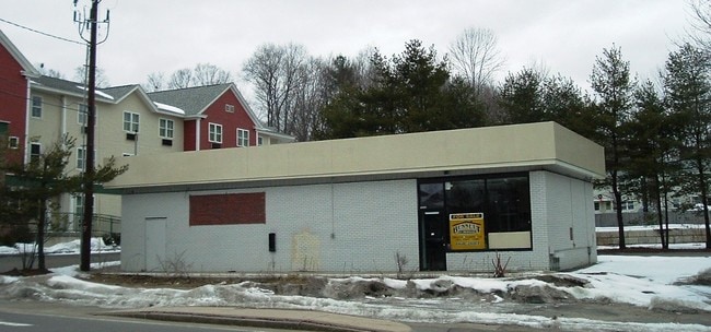
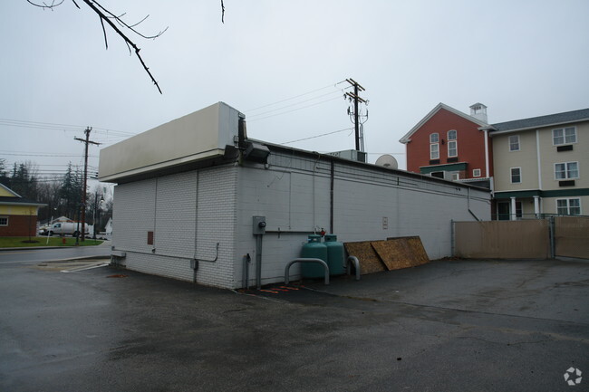
Property Record
3 Dover Rd, Durham, NH 03824

Property Detail
3 Dover Rd
DRHM-000004-000049
Strafford
Departmentstore
New Hampshire
C
38
B and X Area of moderate flood hazard, usually the area between the limits of the 100-year and 500-year floods.
0.25 AC
2024
Strafford County
2024
Boston
080202
Boston-Cambridge-Newton, MA-NH
1,711 SF
NEARBY LISTINGS FOR SALE OR LEASE
-
-
View all Durham listings for sale on LoopNet.com
DEMOGRAPHICS near 3 Dover Rd
1 mile
3 mile
5 mile
2025 Total Population
8,533
18,757
50,798
2030 Population
8,743
19,131
51,721
Pop Growth 2025-2030
+ 2.46%
+ 1.99%
+ 1.82%
Average Age
32
33
38
2025 Total Households
2,040
4,572
19,030
HH Growth 2025-2030
+ 3.77%
+ 3.02%
+ 2.13%
Median Household Inc
$102,991
$110,410
$99,063
Avg Household Size
2.50
2.50
2.30
2025 Avg HH Vehicles
2.00
2.00
2.00
Median Home Value
$483,092
$484,572
$476,302
Median Year Built
1975
1980
1978
Nearby Places
Map Layers
Map Styles
 Street
 Aerial
Transit
 Traffic
 Biking
Places
Listings with unknown addresses are not visible on the map
- Restaurants
- Banks
- Shops
- Fitness
- Groceries
PUBLIC TRANSPORTATION
COMMUTER RAIL
Drive
Walk
Distance
4 min
19 min
1.0 mi
Drive
Walk
Distance
13 min
5.4 mi
AIRPORT
Portsmouth International at Pease
Drive
Walk
Distance
Portsmouth International at Pease
17 min
8.7 mi
Manchester Boston Regional
Drive
Walk
Distance
Manchester Boston Regional
62 min
40.7 mi
Freight Ports
Portland, ME
Drive
Walk
Distance
Portland, ME
75 min
61.0 mi
Nearby Properties
Address
Land Use
TOTAL SIZE
Lot Size
Zoning
Address
Land Use
TOTAL SIZE
Lot Size
Zoning
25.04 AC
RA
Address
Land Use
TOTAL SIZE
Lot Size
Zoning
389 AC
MUDOR
Address
Land Use
TOTAL SIZE
Lot Size
Zoning
358 AC
MUDOR
Address
Land Use
TOTAL SIZE
Lot Size
Zoning
355,634 SF
11.29 AC
OR
Address
Land Use
TOTAL SIZE
Lot Size
Zoning
0.45 AC
RB
Address
Land Use
TOTAL SIZE
Lot Size
Zoning
6.30 AC
CB
Address
Land Use
TOTAL SIZE
Lot Size
Zoning
45.41 AC
ORLI
Address
Land Use
TOTAL SIZE
Lot Size
Zoning
2.61 AC
CB
Address
Land Use
TOTAL SIZE
Lot Size
Zoning
17.01 AC
ORLI
Address
Land Use
TOTAL SIZE
Lot Size
Zoning
39 AC
RA
Address
Land Use
TOTAL SIZE
Lot Size
Zoning
14 AC
RA RE
Address
Land Use
TOTAL SIZE
Lot Size
Zoning
19.67 AC
RA
Address
Land Use
TOTAL SIZE
Lot Size
Zoning
440,697 SF
142.77 AC
ORLI
Address
Land Use
TOTAL SIZE
Lot Size
Zoning
1.10 AC
CB
Address
Land Use
TOTAL SIZE
Lot Size
Zoning
81,332 SF
16.41 AC
RB
Address
Land Use
TOTAL SIZE
Lot Size
Zoning
Address
Land Use
TOTAL SIZE
Lot Size
Zoning
11.47 AC
IT
Address
Land Use
TOTAL SIZE
Lot Size
Zoning
31 AC
MUDOR
Address
Land Use
TOTAL SIZE
Lot Size
Zoning
25 AC
ORLI
Address
Land Use
TOTAL SIZE
Lot Size
Zoning
57.28 AC
IT
Address
Land Use
TOTAL SIZE
Lot Size
Zoning
63,886 SF
2.74 AC
PO
Address
Land Use
TOTAL SIZE
Lot Size
Zoning
Address
Land Use
TOTAL SIZE
Lot Size
Zoning
3.32 AC
MUDOR
Address
Land Use
TOTAL SIZE
Lot Size
Zoning
57.28 AC
IT
Address
Land Use
TOTAL SIZE
Lot Size
Zoning
39,372 SF
12.50 AC
ORLI
Address
Land Use
TOTAL SIZE
Lot Size
Zoning
28.40 AC
DBP
Address
Land Use
TOTAL SIZE
Lot Size
Zoning
30,183 SF
10.66 AC
CB
Address
Land Use
TOTAL SIZE
Lot Size
Zoning
24,308 SF
1.30 AC
PO
Address
Land Use
TOTAL SIZE
Lot Size
Zoning
31,625 SF
0.36 AC
CB
Address
Land Use
TOTAL SIZE
Lot Size
Zoning
16 AC
DBP
The World's #1 Commercial Real Estate Marketplace
Connect with us
© 2026 CoStar Group
The information above has been obtained from sources believed reliable. While we do not doubt its accuracy we have not verified it and make no guarantee, warranty or representation about it. It is your responsibility to independently confirm its accuracy and completeness. Any projections, opinions, assumptions, or estimates used are for example only and do not represent the current or future performance of the property. The value of this transaction to you depends on tax and other factors which should be evaluated by your tax, financial, and legal advisors. You and your advisors should conduct a careful, independent investigation of the property to determine to your satisfaction the suitability of the property for your needs.