Property Record
3 Golfview Ter, Rotonda West, FL 33947

This Property Is For Sale
NEARBY LISTINGS FOR SALE OR LEASE
Property Detail
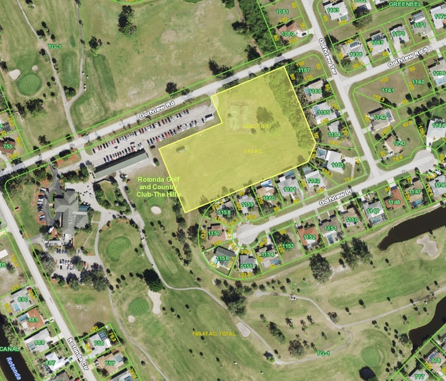
3 Golfview Ter
Punta Gorda, FL
Rotonda West Oakland Hills
412027230001
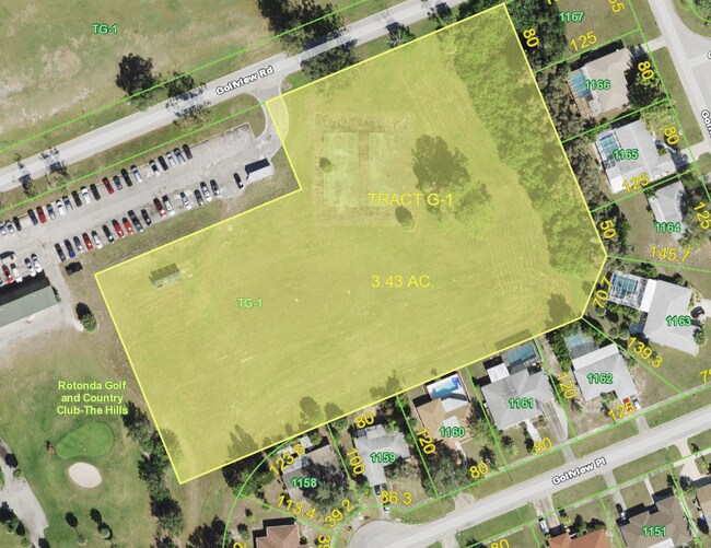
ROTONDA WEST OAKLAND HILLS TRACT G-1 3.43 AC. M/L A PORTION OF TRACT G DESC AS: BEG AT NW COR LOT 1167 TH SW 275 FT SE 200FT SW 238.64 FT SE 240 FT NE ALG LOT LNS FOR 1159 THRU 1162 314.14 FT TO SW COR LOT 1163 TH NE 70.71 FT NW 290 FT TO P.O.B. 28
Residentialacreage
Charlotte
AE
Florida
12015C0193G
1167
2024
3.43 AC
2025
Charlotte County
030505
Southwest Florida
DEMOGRAPHICS near 3 Golfview Ter
1 Mile
3 Mile
5 Mile
2024 Total Population
4,047
22,640
44,578
2029 Population
4,923
27,571
54,340
Pop Growth 2024-2029
+ 21.65%
+ 21.78%
+ 21.90%
Average Age
59
59
58
2024 Total Households
2,122
11,230
21,874
HH Growth 2024-2029
+ 21.91%
+ 21.99%
+ 22.15%
Median Household Inc
$47,796
$59,080
$59,261
Avg Household Size
1.90
2.00
2.00
2024 Avg HH Vehicles
1.00
2.00
2.00
Median Home Value
$227,645
$282,260
$272,595
Median Year Built
1985
1994
1992
Nearby Places
- Restaurants
- Banks
- Shops
- Fitness
- Groceries
PUBLIC TRANSPORTATION
AIRPORT
Punta Gorda
DRIVE
WALK
Distance
Punta Gorda
50 min
28.1 mi
Freight Ports
Port Manatee
DRIVE
WALK
Distance
Port Manatee
86 min
61.5 mi
Nearby Properties
Address
Land Use
TOTAL SIZE
Lot Size
Zoning
Address
Land Use
TOTAL SIZE
Lot Size
Zoning
2,387.99 AC
ES
Address
Land Use
TOTAL SIZE
Lot Size
Zoning
105,990 SF
17.30 AC
RMF15
Address
Land Use
TOTAL SIZE
Lot Size
Zoning
28,490 SF
172 AC
PKR
Address
Land Use
TOTAL SIZE
Lot Size
Zoning
33,654 SF
10.19 AC
RMF5
Address
Land Use
TOTAL SIZE
Lot Size
Zoning
107,736 SF
35.90 AC
RMF5
Address
Land Use
TOTAL SIZE
Lot Size
Zoning
38,036 SF
9.09 AC
RMF15
Address
Land Use
TOTAL SIZE
Lot Size
Zoning
101,160 SF
2.39 AC
CG
Address
Land Use
TOTAL SIZE
Lot Size
Zoning
25,777 SF
12.18 AC
PD
Address
Land Use
TOTAL SIZE
Lot Size
Zoning
25,685 SF
126.18 AC
RMF-T
Address
Land Use
TOTAL SIZE
Lot Size
Zoning
55,760 SF
3.18 AC
CG
Address
Land Use
TOTAL SIZE
Lot Size
Zoning
25,478 SF
11.06 AC
IG
Address
Land Use
TOTAL SIZE
Lot Size
Zoning
106,737 SF
20.80 AC
RMF5
Address
Land Use
TOTAL SIZE
Lot Size
Zoning
40,376 SF
11.18 AC
CG
Address
Land Use
TOTAL SIZE
Lot Size
Zoning
24,708 SF
14.89 AC
CT
Address
Land Use
TOTAL SIZE
Lot Size
Zoning
3,935 SF
36.92 AC
RMF10
Address
Land Use
TOTAL SIZE
Lot Size
Zoning
50,080 SF
5.09 AC
CG
Address
Land Use
TOTAL SIZE
Lot Size
Zoning
15.79 AC
CT
Address
Land Use
TOTAL SIZE
Lot Size
Zoning
38.60 AC
PD
Address
Land Use
TOTAL SIZE
Lot Size
Zoning
26,248 SF
6.32 AC
PD
Address
Land Use
TOTAL SIZE
Lot Size
Zoning
25,130 SF
21.98 AC
RE1
Address
Land Use
TOTAL SIZE
Lot Size
Zoning
27,501 SF
3.82 AC
CG
Address
Land Use
TOTAL SIZE
Lot Size
Zoning
20,160 SF
3.04 AC
CG
Address
Land Use
TOTAL SIZE
Lot Size
Zoning
5,980 SF
0.40 AC
BBI
Address
Land Use
TOTAL SIZE
Lot Size
Zoning
15,190 SF
154.40 AC
RSF5
Address
Land Use
TOTAL SIZE
Lot Size
Zoning
8.47 AC
RMF10
Address
Land Use
TOTAL SIZE
Lot Size
Zoning
4,776 SF
20 AC
II
Address
Land Use
TOTAL SIZE
Lot Size
Zoning
33.01 AC
CG
Address
Land Use
TOTAL SIZE
Lot Size
Zoning
10 AC
RMF10
Address
Land Use
TOTAL SIZE
Lot Size
Zoning
18.62 AC
RMF15
Address
Land Use
TOTAL SIZE
Lot Size
Zoning
12,623 SF
6.37 AC
RMF5
The World's #1 Commercial Real Estate Marketplace
Connect with us
© 2025 CoStar Group
The information above has been obtained from sources believed reliable. While we do not doubt its accuracy we have not verified it and make no guarantee, warranty or representation about it. It is your responsibility to independently confirm its accuracy and completeness. Any projections, opinions, assumptions, or estimates used are for example only and do not represent the current or future performance of the property. The value of this transaction to you depends on tax and other factors which should be evaluated by your tax, financial, and legal advisors. You and your advisors should conduct a careful, independent investigation of the property to determine to your satisfaction the suitability of the property for your needs.