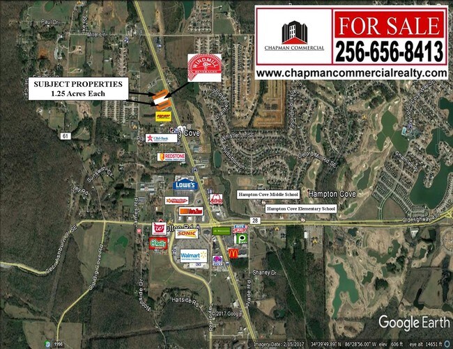
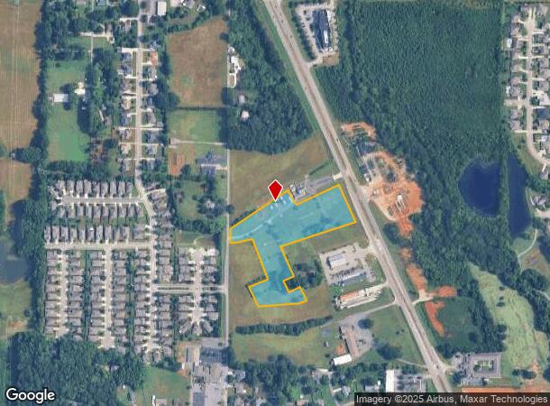
Property Record
6262 Highway 431 S, Owens Cross Roads, AL 35763
NEARBY LISTINGS FOR SALE OR LEASE
Property Detail
6262 Highway 431 S
18-06-23-0-000-078.000
SEC 23 T4S R1E COMM AT THE SW COR OF THE SE 1/4 OF SEC 23 TH N 904 FT TO THE POB TH N 102 FT NE 192 FT SE 119 FT NE TO THE W
Cemetery
Madison
X
Alabama
01089C0361G
7.40 AC
2025
South Huntsville
2025
Huntsville
010905
Huntsville, AL
4,058 SF
DEMOGRAPHICS near 6262 Highway 431 S
1 Mile
3 Mile
5 Mile
2024 Total Population
2,853
21,041
57,998
2029 Population
3,131
23,110
63,826
Pop Growth 2024-2029
+ 9.74%
+ 9.83%
+ 10.05%
Average Age
42
42
43
2024 Total Households
1,166
8,041
23,386
HH Growth 2024-2029
+ 10.29%
+ 10.25%
+ 10.44%
Median Household Inc
$115,068
$122,132
$110,231
Avg Household Size
2.40
2.60
2.40
2024 Avg HH Vehicles
3.00
2.00
2.00
Median Home Value
$400,917
$351,019
$325,455
Median Year Built
2000
1999
1986
Nearby Places
Map Layers
Map Styles
 Street
 Aerial
- Restaurants
- Banks
- Shops
- Fitness
- Groceries
PUBLIC TRANSPORTATION
AIRPORT
Huntsville International-Carl T Jones Field
DRIVE
WALK
Distance
Huntsville International-Carl T Jones Field
33 min
21.3 mi
Freight Ports
Port of Mobile
DRIVE
WALK
Distance
Port of Mobile
401 min
362.5 mi
SALE & LEASE HISTORY
LISTING DATE
SALE/LEASE

Nov 09, 2017
For Sale
Aug 01, 2017
For Sale
Nearby Properties
Address
Land Use
TOTAL SIZE
Lot Size
Zoning
Address
Land Use
TOTAL SIZE
Lot Size
Zoning
7,547 SF
22 AC
Address
Land Use
TOTAL SIZE
Lot Size
Zoning
5,136 SF
22 AC
Address
Land Use
TOTAL SIZE
Lot Size
Zoning
3,168 SF
25.32 AC
Address
Land Use
TOTAL SIZE
Lot Size
Zoning
32,879 SF
14 AC
Address
Land Use
TOTAL SIZE
Lot Size
Zoning
2,932 SF
36.63 AC
Address
Land Use
TOTAL SIZE
Lot Size
Zoning
3,655 SF
10.75 AC
Address
Land Use
TOTAL SIZE
Lot Size
Zoning
175,364 SF
13.18 AC
Address
Land Use
TOTAL SIZE
Lot Size
Zoning
41,354 SF
2.62 AC
Address
Land Use
TOTAL SIZE
Lot Size
Zoning
183,823 SF
22.23 AC
Address
Land Use
TOTAL SIZE
Lot Size
Zoning
4,719 SF
6.94 AC
Address
Land Use
TOTAL SIZE
Lot Size
Zoning
140,769 SF
14.48 AC
Address
Land Use
TOTAL SIZE
Lot Size
Zoning
70,096 SF
7.38 AC
Address
Land Use
TOTAL SIZE
Lot Size
Zoning
66,236 SF
11 AC
Address
Land Use
TOTAL SIZE
Lot Size
Zoning
Address
Land Use
TOTAL SIZE
Lot Size
Zoning
7,690 SF
75.26 AC
Address
Land Use
TOTAL SIZE
Lot Size
Zoning
64,700 SF
6.09 AC
Address
Land Use
TOTAL SIZE
Lot Size
Zoning
12,859 SF
8.38 AC
Address
Land Use
TOTAL SIZE
Lot Size
Zoning
1,710 SF
5.65 AC
Address
Land Use
TOTAL SIZE
Lot Size
Zoning
8,788 SF
9.77 AC
Address
Land Use
TOTAL SIZE
Lot Size
Zoning
54,257 SF
5.80 AC
Address
Land Use
TOTAL SIZE
Lot Size
Zoning
2,717 SF
6.12 AC
Address
Land Use
TOTAL SIZE
Lot Size
Zoning
17,345 SF
4.28 AC
Address
Land Use
TOTAL SIZE
Lot Size
Zoning
66,748 SF
3.28 AC
Address
Land Use
TOTAL SIZE
Lot Size
Zoning
4,200 SF
4 AC
Address
Land Use
TOTAL SIZE
Lot Size
Zoning
42,432 SF
7.71 AC
Address
Land Use
TOTAL SIZE
Lot Size
Zoning
13,000 SF
2.99 AC
Address
Land Use
TOTAL SIZE
Lot Size
Zoning
27,359 SF
2.72 AC
Address
Land Use
TOTAL SIZE
Lot Size
Zoning
14,497 SF
1.75 AC
Address
Land Use
TOTAL SIZE
Lot Size
Zoning
8,260 SF
1.08 AC
Address
Land Use
TOTAL SIZE
Lot Size
Zoning
15,219 SF
12 AC
The World's #1 Commercial Real Estate Marketplace
Connect with us
© 2025 CoStar Group
The information above has been obtained from sources believed reliable. While we do not doubt its accuracy we have not verified it and make no guarantee, warranty or representation about it. It is your responsibility to independently confirm its accuracy and completeness. Any projections, opinions, assumptions, or estimates used are for example only and do not represent the current or future performance of the property. The value of this transaction to you depends on tax and other factors which should be evaluated by your tax, financial, and legal advisors. You and your advisors should conduct a careful, independent investigation of the property to determine to your satisfaction the suitability of the property for your needs.