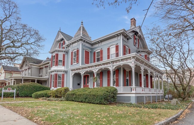
Property Record
3 Main St, High Bridge, NJ 08829


Property Detail
3 Main St
09-00014-0000-00014
Hunterdon
Vacantlandnec
New Jersey
PO
14
B and X Area of moderate flood hazard, usually the area between the limits of the 100-year and 500-year floods.
0.41 AC
2024
Hunterdon
2025
Northern New Jersey
011400
Newark, NJ
4,019 SF
NEARBY LISTINGS FOR SALE OR LEASE
DEMOGRAPHICS near 3 Main St
1 mile
3 mile
5 mile
2025 Total Population
8,103
25,648
37,881
2030 Population
8,415
26,426
38,822
Pop Growth 2025-2030
+ 3.85%
+ 3.03%
+ 2.48%
Average Age
39
42
43
2025 Total Households
3,096
9,744
14,176
HH Growth 2025-2030
+ 3.81%
+ 3.06%
+ 2.52%
Median Household Inc
$92,560
$124,706
$141,482
Avg Household Size
2.50
2.60
2.60
2025 Avg HH Vehicles
2.00
2.00
2.00
Median Home Value
$432,647
$492,364
$559,509
Median Year Built
1973
1983
1983
Nearby Places
Map Layers
Map Styles
 Street
 Aerial
Transit
 Traffic
 Biking
Places
Listings with unknown addresses are not visible on the map
- Restaurants
- Banks
- Shops
- Fitness
- Groceries
PUBLIC TRANSPORTATION
COMMUTER RAIL
High Bridge (Raritan Valley Line - NJ Transit Commuter Rail (NJ Transit))
Drive
Walk
Distance
High Bridge (Raritan Valley Line - NJ Transit Commuter Rail (NJ Transit))
2 min
12 min
0.6 mi
Annandale (Raritan Valley Line - NJ Transit Commuter Rail (NJ Transit))
Drive
Walk
Distance
Annandale (Raritan Valley Line - NJ Transit Commuter Rail (NJ Transit))
8 min
4.6 mi
AIRPORT
Trenton Mercer
Drive
Walk
Distance
Trenton Mercer
51 min
33.3 mi
Lehigh Valley International
Drive
Walk
Distance
Lehigh Valley International
54 min
35.3 mi
Freight Ports
New York Container Terminal
Drive
Walk
Distance
New York Container Terminal
65 min
48.8 mi
SALE & LEASE HISTORY
LISTING DATE
SALE/LEASE

Feb 21, 2024
For Lease
Dec 21, 2023
For Sale
Nearby Properties
Address
Land Use
TOTAL SIZE
Lot Size
Zoning
Address
Land Use
TOTAL SIZE
Lot Size
Zoning
1,740.74 AC
INS
Address
Land Use
TOTAL SIZE
Lot Size
Zoning
500.58 AC
WM
Address
Land Use
TOTAL SIZE
Lot Size
Zoning
3,432 SF
24.17 AC
OB3
Address
Land Use
TOTAL SIZE
Lot Size
Zoning
56.97 AC
R3
Address
Land Use
TOTAL SIZE
Lot Size
Zoning
255.40 AC
WM
Address
Land Use
TOTAL SIZE
Lot Size
Zoning
215.75 AC
RC
Address
Land Use
TOTAL SIZE
Lot Size
Zoning
2,526 SF
339.93 AC
RC
Address
Land Use
TOTAL SIZE
Lot Size
Zoning
40.13 AC
AH2
Address
Land Use
TOTAL SIZE
Lot Size
Zoning
Address
Land Use
TOTAL SIZE
Lot Size
Zoning
261.91 AC
RC
Address
Land Use
TOTAL SIZE
Lot Size
Zoning
Address
Land Use
TOTAL SIZE
Lot Size
Zoning
9,408 SF
37 AC
ROM1
Address
Land Use
TOTAL SIZE
Lot Size
Zoning
5.36 AC
PUD
Address
Land Use
TOTAL SIZE
Lot Size
Zoning
Address
Land Use
TOTAL SIZE
Lot Size
Zoning
1.88 AC
OB-2
Address
Land Use
TOTAL SIZE
Lot Size
Zoning
52,594 SF
4.58 AC
GA
Address
Land Use
TOTAL SIZE
Lot Size
Zoning
10.18 AC
OB-4
Address
Land Use
TOTAL SIZE
Lot Size
Zoning
5.24 AC
C-N
Address
Land Use
TOTAL SIZE
Lot Size
Zoning
34.80 AC
ROM
Address
Land Use
TOTAL SIZE
Lot Size
Zoning
2,544 SF
562.37 AC
RC
Address
Land Use
TOTAL SIZE
Lot Size
Zoning
Address
Land Use
TOTAL SIZE
Lot Size
Zoning
8.97 AC
Address
Land Use
TOTAL SIZE
Lot Size
Zoning
47,400 SF
15.68 AC
I
Address
Land Use
TOTAL SIZE
Lot Size
Zoning
11,467 SF
8.98 AC
OB-2
Address
Land Use
TOTAL SIZE
Lot Size
Zoning
Address
Land Use
TOTAL SIZE
Lot Size
Zoning
14,526 SF
5.03 AC
R-2A
Address
Land Use
TOTAL SIZE
Lot Size
Zoning
11,584 SF
4.17 AC
C1
Address
Land Use
TOTAL SIZE
Lot Size
Zoning
7.14 AC
R-2A
Address
Land Use
TOTAL SIZE
Lot Size
Zoning
5.64 AC
C-4
Address
Land Use
TOTAL SIZE
Lot Size
Zoning
2.44 AC
C-4
The World's #1 Commercial Real Estate Marketplace
Connect with us
© 2026 CoStar Group
The information above has been obtained from sources believed reliable. While we do not doubt its accuracy we have not verified it and make no guarantee, warranty or representation about it. It is your responsibility to independently confirm its accuracy and completeness. Any projections, opinions, assumptions, or estimates used are for example only and do not represent the current or future performance of the property. The value of this transaction to you depends on tax and other factors which should be evaluated by your tax, financial, and legal advisors. You and your advisors should conduct a careful, independent investigation of the property to determine to your satisfaction the suitability of the property for your needs.