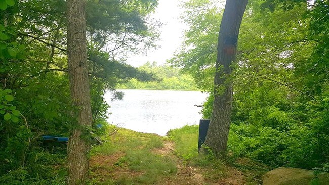
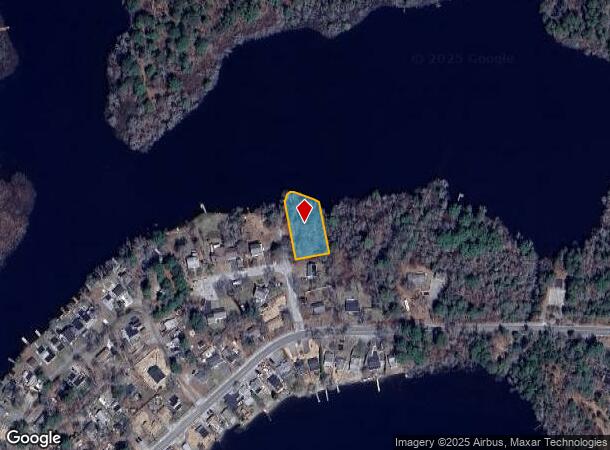
Property Record
3 Michael Dr, East Wareham, MA 02538

NEARBY LISTINGS FOR SALE OR LEASE
Property Detail
3 Michael Dr
WARE-000129-000000-000000-K000003
Plymouth
Residentialacreage
Massachusetts
AE
k3
25023C0493K
0.37 AC
2025
Route 3 South
2025
Boston
545200
Boston-Cambridge-Newton, MA-NH
DEMOGRAPHICS near 3 Michael Dr
1 Mile
3 Mile
5 Mile
2024 Total Population
1,437
16,786
39,117
2029 Population
1,443
16,984
39,909
Pop Growth 2024-2029
+ 0.42%
+ 1.18%
+ 2.02%
Average Age
44
45
45
2024 Total Households
634
7,252
16,227
HH Growth 2024-2029
+ 0.16%
+ 0.97%
+ 1.91%
Median Household Inc
$70,356
$72,091
$75,730
Avg Household Size
2.20
2.20
2.30
2024 Avg HH Vehicles
2.00
2.00
2.00
Median Home Value
$275,390
$386,090
$401,286
Median Year Built
1969
1956
1968
Nearby Places
Map Layers
Map Styles
 Street
 Aerial
- Restaurants
- Banks
- Shops
- Fitness
- Groceries
PUBLIC TRANSPORTATION
COMMUTER RAIL
DRIVE
WALK
Distance
7 min
3.2 mi
DRIVE
WALK
Distance
10 min
4.2 mi
AIRPORT
Martha's Vineyard
DRIVE
WALK
Distance
Martha's Vineyard
99 min
38.9 mi
Freight Ports
Port of New Bedford Harbor
DRIVE
WALK
Distance
Port of New Bedford Harbor
31 min
20.8 mi
SALE & LEASE HISTORY
LISTING DATE
SALE/LEASE

Feb 08, 2018
For Sale
Nearby Properties
Address
Land Use
TOTAL SIZE
Lot Size
Zoning
Address
Land Use
TOTAL SIZE
Lot Size
Zoning
163,433 SF
7.47 AC
Address
Land Use
TOTAL SIZE
Lot Size
Zoning
167,599 SF
0.34 AC
Address
Land Use
TOTAL SIZE
Lot Size
Zoning
142,390 SF
5.80 AC
Address
Land Use
TOTAL SIZE
Lot Size
Zoning
19.77 AC
Address
Land Use
TOTAL SIZE
Lot Size
Zoning
11,930 SF
4.81 AC
Address
Land Use
TOTAL SIZE
Lot Size
Zoning
12,812 SF
19.12 AC
Address
Land Use
TOTAL SIZE
Lot Size
Zoning
8.89 AC
Address
Land Use
TOTAL SIZE
Lot Size
Zoning
116,476 SF
13.22 AC
Address
Land Use
TOTAL SIZE
Lot Size
Zoning
60.89 AC
Address
Land Use
TOTAL SIZE
Lot Size
Zoning
117,814 SF
16.49 AC
Address
Land Use
TOTAL SIZE
Lot Size
Zoning
750 AC
RR
Address
Land Use
TOTAL SIZE
Lot Size
Zoning
4,959 SF
2.30 AC
Address
Land Use
TOTAL SIZE
Lot Size
Zoning
30,195 SF
0.82 AC
Address
Land Use
TOTAL SIZE
Lot Size
Zoning
41,185 SF
14.91 AC
Address
Land Use
TOTAL SIZE
Lot Size
Zoning
65,856 SF
6.70 AC
Address
Land Use
TOTAL SIZE
Lot Size
Zoning
6.30 AC
Address
Land Use
TOTAL SIZE
Lot Size
Zoning
4.20 AC
Address
Land Use
TOTAL SIZE
Lot Size
Zoning
32.24 AC
Address
Land Use
TOTAL SIZE
Lot Size
Zoning
Address
Land Use
TOTAL SIZE
Lot Size
Zoning
22.30 AC
Address
Land Use
TOTAL SIZE
Lot Size
Zoning
21,240 SF
2.79 AC
Address
Land Use
TOTAL SIZE
Lot Size
Zoning
12.32 AC
Address
Land Use
TOTAL SIZE
Lot Size
Zoning
Address
Land Use
TOTAL SIZE
Lot Size
Zoning
24,815 SF
2.16 AC
Address
Land Use
TOTAL SIZE
Lot Size
Zoning
11.36 AC
Address
Land Use
TOTAL SIZE
Lot Size
Zoning
4,024 SF
1.15 AC
Address
Land Use
TOTAL SIZE
Lot Size
Zoning
10,500 SF
13.40 AC
Address
Land Use
TOTAL SIZE
Lot Size
Zoning
6.20 AC
Address
Land Use
TOTAL SIZE
Lot Size
Zoning
11,002 SF
1.40 AC
Address
Land Use
TOTAL SIZE
Lot Size
Zoning
345.16 AC
The World's #1 Commercial Real Estate Marketplace
Connect with us
© 2026 CoStar Group
The information above has been obtained from sources believed reliable. While we do not doubt its accuracy we have not verified it and make no guarantee, warranty or representation about it. It is your responsibility to independently confirm its accuracy and completeness. Any projections, opinions, assumptions, or estimates used are for example only and do not represent the current or future performance of the property. The value of this transaction to you depends on tax and other factors which should be evaluated by your tax, financial, and legal advisors. You and your advisors should conduct a careful, independent investigation of the property to determine to your satisfaction the suitability of the property for your needs.