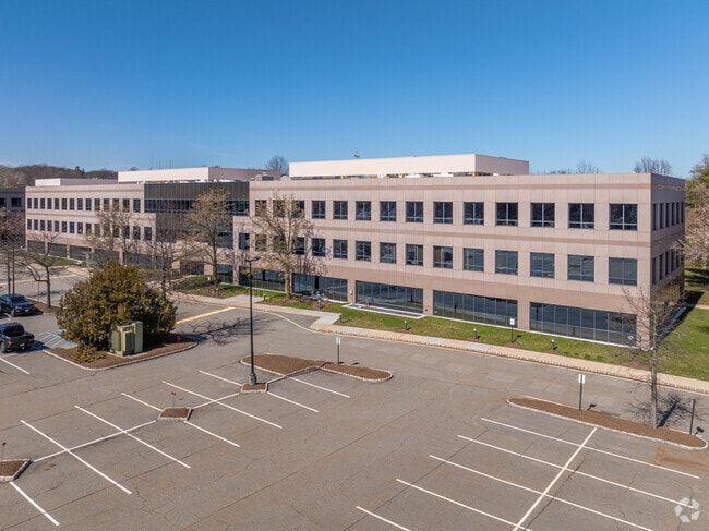
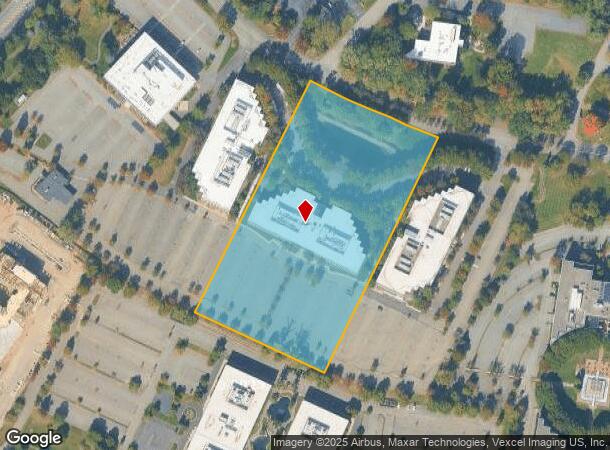
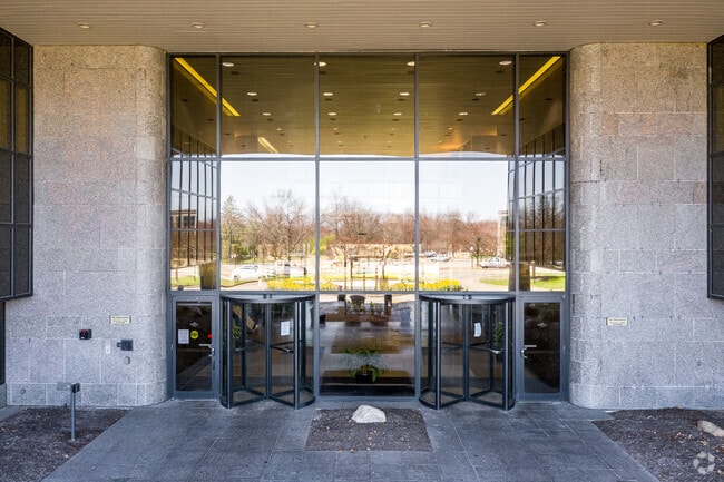
Property Record
3 Sylvan Way, Parsippany, NJ 07054

Current Lease Availabilities
NEARBY LISTINGS FOR SALE OR LEASE
Property Detail
3 Sylvan Way
Newark, NJ-PA
Morris
29-00202-0000-00004-2
New Jersey
Commercialnec
4.2
2024
7.53 AC
2025
Parsippany
041802
Northern New Jersey
DEMOGRAPHICS near 3 Sylvan Way
1 Mile
3 Mile
5 Mile
2024 Total Population
5,914
62,511
158,587
2029 Population
5,928
62,698
158,925
Pop Growth 2024-2029
+ 0.24%
+ 0.30%
+ 0.21%
Average Age
43
42
42
2024 Total Households
2,066
23,605
60,445
HH Growth 2024-2029
+ 0.34%
+ 0.28%
+ 0.30%
Median Household Inc
$137,395
$127,887
$126,263
Avg Household Size
2.80
2.60
2.50
2024 Avg HH Vehicles
2.00
2.00
2.00
Median Home Value
$498,729
$546,977
$564,177
Median Year Built
1966
1969
1968
Nearby Places
- Restaurants
- Banks
- Shops
- Fitness
- Groceries
PUBLIC TRANSPORTATION
COMMUTER RAIL
Morris Plains (Morris & Essex Morristown Line - NJ Transit Commuter Rail (NJ Transit))
DRIVE
WALK
Distance
Morris Plains (Morris & Essex Morristown Line - NJ Transit Commuter Rail (NJ Transit))
5 min
2.1 mi
Mount Tabor (Morris & Essex Morristown Line - NJ Transit Commuter Rail (NJ Transit))
DRIVE
WALK
Distance
Mount Tabor (Morris & Essex Morristown Line - NJ Transit Commuter Rail (NJ Transit))
7 min
3.6 mi
AIRPORT
Newark Liberty International
DRIVE
WALK
Distance
Newark Liberty International
33 min
24.7 mi
LaGuardia
DRIVE
WALK
Distance
LaGuardia
57 min
42.2 mi
Freight Ports
Maher Terminal
DRIVE
WALK
Distance
Maher Terminal
37 min
25.2 mi
Nearby Properties
Address
Land Use
TOTAL SIZE
Lot Size
Zoning
Address
Land Use
TOTAL SIZE
Lot Size
Zoning
2,023 SF
136.41 AC
R-R
Address
Land Use
TOTAL SIZE
Lot Size
Zoning
48.76 AC
OBRL
Address
Land Use
TOTAL SIZE
Lot Size
Zoning
596 SF
64.81 AC
OBRL
Address
Land Use
TOTAL SIZE
Lot Size
Zoning
18.42 AC
RM
Address
Land Use
TOTAL SIZE
Lot Size
Zoning
577,851 SF
35.90 AC
SD5A
Address
Land Use
TOTAL SIZE
Lot Size
Zoning
13.10 AC
R-25
Address
Land Use
TOTAL SIZE
Lot Size
Zoning
11,353 SF
9.29 AC
COD
Address
Land Use
TOTAL SIZE
Lot Size
Zoning
114,267 SF
27.26 AC
SED5
Address
Land Use
TOTAL SIZE
Lot Size
Zoning
14.50 AC
RG
Address
Land Use
TOTAL SIZE
Lot Size
Zoning
257,220 SF
30.83 AC
SED5
Address
Land Use
TOTAL SIZE
Lot Size
Zoning
38.86 AC
L
Address
Land Use
TOTAL SIZE
Lot Size
Zoning
32 AC
R-1M
Address
Land Use
TOTAL SIZE
Lot Size
Zoning
4.94 AC
OLV
Address
Land Use
TOTAL SIZE
Lot Size
Zoning
88,345 SF
15.67 AC
R-7
Address
Land Use
TOTAL SIZE
Lot Size
Zoning
3.86 AC
O-3
Address
Land Use
TOTAL SIZE
Lot Size
Zoning
377,114 SF
40.64 AC
SD10
Address
Land Use
TOTAL SIZE
Lot Size
Zoning
Address
Land Use
TOTAL SIZE
Lot Size
Zoning
11.80 AC
I/B
Address
Land Use
TOTAL SIZE
Lot Size
Zoning
13.45 AC
IP
Address
Land Use
TOTAL SIZE
Lot Size
Zoning
25.14 AC
I-B3
Address
Land Use
TOTAL SIZE
Lot Size
Zoning
26,967 SF
14.06 AC
OB-4
Address
Land Use
TOTAL SIZE
Lot Size
Zoning
22.85 AC
B-3
Address
Land Use
TOTAL SIZE
Lot Size
Zoning
16.01 AC
R-C
Address
Land Use
TOTAL SIZE
Lot Size
Zoning
23.15 AC
SD10
Address
Land Use
TOTAL SIZE
Lot Size
Zoning
27,120 SF
29.27 AC
I
Address
Land Use
TOTAL SIZE
Lot Size
Zoning
1,440 SF
38.80 AC
I-2
Address
Land Use
TOTAL SIZE
Lot Size
Zoning
28.84 AC
OBDS
Address
Land Use
TOTAL SIZE
Lot Size
Zoning
18.97 AC
RG-5
Address
Land Use
TOTAL SIZE
Lot Size
Zoning
333,991 SF
15.76 AC
SD10
Address
Land Use
TOTAL SIZE
Lot Size
Zoning
756 SF
16.46 AC
I
The World's #1 Commercial Real Estate Marketplace
Connect with us
© 2025 CoStar Group
The information above has been obtained from sources believed reliable. While we do not doubt its accuracy we have not verified it and make no guarantee, warranty or representation about it. It is your responsibility to independently confirm its accuracy and completeness. Any projections, opinions, assumptions, or estimates used are for example only and do not represent the current or future performance of the property. The value of this transaction to you depends on tax and other factors which should be evaluated by your tax, financial, and legal advisors. You and your advisors should conduct a careful, independent investigation of the property to determine to your satisfaction the suitability of the property for your needs.